Kvadraturen (Kristiansand)

Last updated
Kvadraturen
Borough of Kristiansand
Kvadraturen-01.jpg
Markens gate, Kristiansand.jpg
Descending, from top: Kvadraturen also known as downtown, bottom: Markens gate
Kristiansand komm.svg
Coat of arms
Kristiansand-borughs-kvadraturen.png
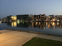
Location of Kvadraturen, shown in yellow, in Kristiansand
Coordinates: 58°08′48″N7°59′43″E / 58.1468°N 07.9953°E / 58.1468; 07.9953 Coordinates: 58°08′48″N7°59′43″E / 58.1468°N 07.9953°E / 58.1468; 07.9953
Country Flag of Norway.svg  Norway
Region Southern Norway
County Vest-Agder
District Kristiansand
Municipality Kristiansand
Elevation
[1]
7 m (23 ft)
Population
 (2015)
  Total6,750
Time zone UTC+01:00 (CET)
  Summer (DST) UTC+02:00 (CEST)
Post Code prefix
460*, 461*
Website kvadraturen.no
kristiansand.kommune.no

Kvadraturen is the city center of Kristiansand in Vest-Agder county, Norway, with a population of 6,750 (2015). The borough is made up of the centre together with the harbour to the south and the more rural district of "Eg" to the north. Kvadraturen is the administrative centre of the municipality of Kristiansand as well as the administrative centre of Vest-Agder county, but is far smaller in area than the other boroughs in the municipality, such as the borough of Grim to the north and west, and the borough of Lund to the east.

Contents

Kvadraturen is the location of the Kristiansand Cathedral and the nearby commercial, pedestrian street is Markens gate. The city harbour is located along the Kristiansandsfjorden and the island of Odderøya. The borough has three malls and three high schools. The closest public junior high is "Grim Skole" and the closest elementary is Tordenskjoldsgate Skole and is the only remanding elementary in Kvadraturen. The Sørlandet Hospital Kristiansand is also located in the borough, in the district of Eg.

The main city centre was established as a city on 5 July 1641 by King Christian IV. The city became a self-governing municipality under the formannskapsdistrikt law on 1 January 1838. On 1 July 1921, a neighboring part of the municipality of Oddernes (population: 2,164) was transferred from Oddernes to the city of Kristiansand. During the 1960s, there were many municipal mergers across Norway due to the work of the Schei Committee. On 1 January 1965, the city of Kristiansand (population: 27,100) was merged with the neighboring municipalities of Randesund (population: 1,672), Oddernes (population: 18,668), and Tveit (population: 2,802) to form a new, larger municipality of Kristiansand. [2]

Shopping

Markens gate is the main pedestrian street in Kristiansand. It is one of Norway's most walked street and is over 2,778 feet (847 meters) long. The street has many different stores. The walking zone stretches over seven blocks. During the 1600-1700s, the street was called Dronningens gate, and today its also nicknamed Stripen (The Strip).

The most central part of the city is lower Markens where it meets Tollbodgata. Some stores here are open 24/7 and it is here most crimes of downtown Kristiansand take place. Chain restaurants like 7-Eleven, McDonald's, and Deli de Luca are also located there.

There are three malls at Kvadraturen: Sandens is the largest and newest one, Slottet Shopping is located at the north end of Markens gate in the north. Lille Markens is the smallest mall. [3] [4]

Transportation

Kristiansand Bus Terminal, Kristiansand Station, and Kristiansand Harbor are all located at Vestre Strandgate next to each other. [5] Local buses goes from Henrik Wergelandsgate and Tollbodgata.

Kristiansand Station has daily trains to Oslo and Stavanger. [6] Kristiansand Harbor has many daily ferry routes to Hirtshals, Denmark.

Kristiansand Airport, Kjevik is located 16 kilometres (9.9 mi) from the city center, and it has routes to the biggest cities in Norway, with less frequent routes to other Northern European cities.

Education

There are two public and one private high schools and one elementary school in the borough of Kvadraturen. The elementary school has students from over 27 different nationalities. The closest junior high schools are in the nearby boroughs of Grim and Lund. [7]

List of schools in Kvadraturen
NameLocationType [8]
Kvadraturen skolesenter Tollbodgata High School
Noroff videregående skoleElvegataHigh School
Tangen High School TangenHigh School
Tordenskjoldsgate skoleNybyenElementary

Politics

The largest political parties in Kvadraturen (2019):

Kristiansand city council votes from Kvadraturen 2019 [9]
Labour Party 21,7% (684 votes)
Conservative Party 19,4% (611 votes)
Socialist Left Party 10,3% (326 votes)
Green Party 10,0% (315 votes)
The Democrats 8,2% (257 votes)
Christian Democratic Party 6,6% (207 votes)
Liberal Party 5,7% (181 votes)
Progress Party 4,6% (144 votes)
Red 4,3% (135 votes)
Centre 2,8% (89 votes)
The Christians Party 1,2% (37 votes)
Pensioners' Party 0,9%% (28 votes)
The Capitalist Party 0,4% (14 votes)
Health Party 0,4% (12 votes)
Others3,6% (112 votes)
Total 7 386 votes

Tourism

The borough of Kvadraturen is the site of many tourist attractions. Christiansholm Fortress was built in 1672. The Kilden Theatre, the largest culture house and theatre in Southern Norway, is located on the island of Odderøya. It was finished in 2012 and has a capacity of over 2,000.

Fiskebrygga (The Fish Wharf), a former fish landing in Kvadraturen with Odderøya, has been redeveloped as a restaurant, shopping, and tourist destination. [10]

Neighbourhoods

Kvadraturen sorost Kongens gate, Kristiansand.jpg
Kvadraturen sørøst

Related Research Articles

Kristiansand City in Norway

Kristiansand, historically spelled Christianssand and Christiansand, is a city and municipality Agder county, Norway. It is the fifth largest city in Norway and the municipality is the sixth largest in Norway, with a population of around 112,000 as of January 2020, following the incorporation of the municipalities of Søgne and Songdalen into the new and revised municipality of greater Kristiansand. In addition to the city itself, Statistics Norway counts four other densely populated areas in the municipality: Skålevik in Flekkerøy with a population of 3,526 in the Vågsbygd borough, Strai with a population of 1,636 in the Grim borough, Justvik with a population of 1,803 in the Lund borough, and Tveit with a population of 1,396 in the Oddernes borough. Kristiansand is divided into five boroughs: Grim, which is located northwest in Kristiansand with a population of 15,000; Kvadraturen, which is the centre and downtown Kristiansand with a population of 5,200; Lund, the second largest borough; Søgne, with a population of around 12,000 and incorporated into the municipality of Kristiansand as of January 2020; Oddernes, a borough located in the west; and Vågsbygd, the largest borough with a population of 36,000, located in the southwest.

Presteheia Neighborhood in Kristiansand in Vest-Agder, Norway

Presteheia is a neighborhood in the city of Kristiansand in Vest-Agder county, Norway. It is located in the borough of Lund in the district of Gimlekollen. It is located to the west of Bjørndalssletta, north of Oddemarka, and east of Gimlemoen. The neighborhood developed after the year 2000 has many "rekkehus" and terrace blocks. The residents of the area are both young families and elderly people. The view from Presteheia is magnificent overlooking the borough of Lund, the University of Agder, and the downtown Kvadraturen area. You can see both Oksoy and the island of Odderøya from the top of Presteheia.

Strai District in Kristiansand in Southern Norway, Norway

Strai is a village and a district in the municipality of Kristiansand in Vest-Agder, Norway. It is located in the borough of Grim. Its population (2014) is about 1,000. The district of Mosby lies to the north, the districts of Lund, Kvadraturen, and Grim are located to the south, and the municipality of Songdalen lies to the west.

Oddernes Borough of Kristiansand in Southern Norway, Norway

Oddernes is a borough in the municipality of Kristiansand in Vest-Agder county, Norway. The borough covers eastern Kristiansand on the east side of the Topdalsfjorden and the Varodd Bridge. The borough includes the former municipalities of Randesund and Tveit. There was a municipality of Oddernes from 1838 until 1965, but its boundaries were very different from those of the present-day borough.

Fiskebrygga, Kristiansand


Fiskebrygga is a former fish landing in the city of Kristiansand in Vest-Agder county, Norway. The buildings have been redeveloped as a restaurant, shopping area, and tourist destination.

Odderøya Island in central Kristiansand, Norway

Odderøya is an island and neighborhoods in Kristiansand municipality in Vest-Agder county, Norway. The 0.7-square-kilometre (170-acre) island lies immediately to the south of the city centre of Kristiansand and it is connected to the mainland by four bridges. The island creates a natural division between the eastern and western parts of the port of Kristiansand.

Vågsbygd Borough of Kristiansand in Southern Norway, Norway

Vågsbygd is a borough and district in the city of Kristiansand in Vest-Agder county, Norway. It is the largest borough and district in Kristiansand. Until 1965, Vågsbygd was a part of Oddernes municipality. The borough includes the districts of Flekkerøy, Voiebyen, Vågsbygd/Augland, and Slettheia. The Kristiansand Cannon Museum on Kroodden is an authentic fortress from World War II.

Hellemyr District in Kristiansand in Southern Norway, Norway

Hellemyr is a district in the city of Kristiansand in Vest-Agder county, Norway. It has a population of 2,990. The district is located in the borough of Grim. The district of Tinnheia lies to the east, the district of Slettheia lies to the south, the district of Grim lies to the north, and the municipality of Songdalen lies to the west. Hellemyr is the last district to drive through before exiting Kristiansand via the European route E39 highway.

Grim (Kristiansand) Borough of Kristiansand in Southern Norway, Norway

Grim is a borough in the city of Kristiansand in Vest-Agder county, Norway. The borough has a population of about 16,000 people and is the second least populated borough in Kristiansand. Grim is located in the northwestern part of the municipality, north of Vågsbygd borough, northwest of Kvadraturen borough, and west of Lund borough. Grim also borders Songdalen and Vennesla municipalities to the west and north, respectively.

Lund (Kristiansand) Borough of Kristiansand in Southern Norway, Norway

Lund is a borough and district in the city of Kristiansand in Vest-Agder county, Norway. It is the second largest borough in the city after Vågsbygd. In 2015, the population was about 30,000. Lund is divided into 4 districts: Lund (centrum), Gimlekollen, Justvik, and Ålefjær.

Vestre Strandgate street in Kristiansand, Norway

Vestre Strandgate is a street and a road in Kristiansand, Norway. The road is a part of National Road 471 and starts after Riksvei 9 ends in Kvadraturen.

Tollbodgata street in Kristiansand, Norway

Tollbodgata is a street in Kristiansand, Norway. The street is one way westbound with sidewalks on both sides of the road. It consists mostly of apartments, houses and stores.

Sørlandet Hospital Kristiansand hospital in Norway

Sørlandet Hospital Kristiansand is located in Kristiansand, Vest-Agder County in Norway, and is one of the three public hospitals within the Hospital of Southern Norway and is a regional hospital. It was previously called Kristiansand Sentralsykehus and was located in Tordenskjoldsgate in Kvadraturen.

Grovikheia Neighborhood in Kristiansand in Vest-Agder, Norway

Grovikheia is a neighbourhood in the city of Kristiansand in Vest-Agder county, Norway. It is a part of the borough of Oddernes and in the district of Hånes. It is located along the Norwegian National Road 41 and it is north of the Hånni neighborhood and northwest of Lauvåsen. The name Grovikheia comes from the cove Grovika.

Eg (Kristiansand) Neighbourhood in Kristiansand in Kristiansand, Vest-Agder

Eg is a neighbourhood in the city of Kristiansand in Vest-Agder county, Norway. It is the only neighborhood in the borough that is located outside of the downtown city centre of Kristiansand. The main hospital for all of Southern Norway, Sørlandet Hospital Kristiansand, is located on the north side of Eg. Eg is located between the river Otra and the Baneheia park.

Tømmerstø Neighborhood in Kristiansand in Vest-Agder, Norway

Tømmerstø is a neighbourhood in the city of Kristiansand in Vest-Agder county, Norway. It's located in the borough of Oddernes and in the district of Randesund. The neighborhood of Odderhei lies to the northwest, Holte and Frikstad lie to the northeast, and Kongshavn lies to the southeast.

Tangen (Kristiansand)

Tangen is a pier and neighborhood in Kristiansand, Norway. It is a part of the Kvadraturen (Kristiansand)|Kvadraturen borough and is mostly populated with new apartments, there is one high school with the pier and Tangen is next to the beach Bystranda. The main quarter for NRK Southern Norway is located at Tangen.

Slettheitoppen Neighborhood in Kristiansand in Vest-Agder, Norway

Slettheitoppen or Øvre Slettheia is a neighbourhood in the city of Kristiansand in Vest-Agder county, Norway. It is located in the borough of Vågsbygd and in the district of Slettheia. The neighborhood lies west of Trane and northwest of Nedre Slettheia. The Øvre Slettheia skole is an elementary school in the neighbourhood.

Posebyen

Posebyen is a neighbourhood in the city of Kristiansand in Vest-Agder county, Norway. Posebyen is located in the downtown borough of Kvadraturen, along the western shore of the river Otra. It consists mostly of large, white, wooden houses, many of which were left intact after the big city fire in 1892. Therefore, it forms the largest continuous collection of old wooden houses in any city in Northern Europe.

Markens gate street in Kristiansand, Norway

Markens gate is the main pedestrian street in Kristiansand, Norway. It is located in the west of the borough Kvadraturen and the length of the entire street is 1 kilometer, while the pedestrian part is 550 meters and another 160 meters with Otterdalsparken. The streets goes from Slottet Mall in the north and is a pedestrian street all the way down to Dronningens gate, it's only crossed by traffic from Tordenskjolds gate, Kristian IVs gate and Henrik Wergelands gate before Dronningens gate. The pedestrian parts stretches over 7 quarters. Compared to other Norwegian cities, Markens street is one of the most walked streets in the country.

References

  1. "Wergelandsparken, Kristiansand (Vest-Agder)". yr.no . Retrieved 2017-02-19.
  2. Jukvam, Dag (1999). "Historisk oversikt over endringer i kommune- og fylkesinndelingen" (PDF) (in Norwegian). Statistisk sentralbyrå.
  3. "Kvadraturen". kvadraturen.no. Retrieved 2017-02-21.
  4. "Shopping in Kristiansand Centre". visitnorway.com. Retrieved 2017-02-21.
  5. "AKT". akt.no. Retrieved 2017-02-21.
  6. "NSB". nsb.no. Retrieved 2017-02-21.
  7. "VI Hjelper deg på Nett". minskole.no. Retrieved 2017-02-21.
  8. "MinSkole".
  9. "NRK - valgresultat for Kvadraturen 2019". NRK VALGRESULTAT 2019 (in Norwegian). NRK.NO.
  10. "Visit Norway". VisitNorway.com. Retrieved 2017-02-21.