
Kristiansand is a city and municipality in Agder county, Norway. The city is the fifth-largest and the municipality is the sixth-largest in Norway, with a population of around 116,000 as of January 2020, following the incorporation of the municipalities of Søgne and Songdalen into the greater Kristiansand municipality. In addition to the city itself, Statistics Norway count four other densely populated areas in the municipality: Skålevik in Flekkerøy with a population of 3,526 in the Vågsbygd borough, Strai with a population of 1,636 in the Grim borough, Justvik with a population of 1,803 in the Lund borough, and Tveit with a population of 1,396 in the Oddernes borough. Kristiansand is divided into five boroughs; -Grim, which is located northwest in Kristiansand with a population of 15,000; Kvadraturen, which is the centre and downtown Kristiansand with a population of 5,200; Lund, the second largest borough; Søgne, with a population of around 12,000 and incorporated into the municipality of Kristiansand as of January 2020; Oddernes, a borough located in the west; and Vågsbygd, the largest borough with a population of 36,000, located in the southwest.

Southern Norway is the geographical region (landsdel) along the Skagerrak coast of southern Norway. The region is an informal description since it does not have any governmental function. It roughly corresponds to the old petty kingdom of Agder being coextensive with the county, as well as the two former counties of Vest-Agder and Aust-Agder. From New Year 2020, the two counties have been merged into one county, Agder. The total combined area of Vest-Agder and Aust-Agder counties is 16,493 square kilometres (6,368 sq mi). The name is relatively new, having first been used in Norway around 1900.

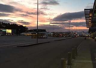
Kristiansand Airport, Kjevik is an international airport serving Kristiansand Municipality in Agder county, Norway. The airport is located in the district of Tveit in the Oddernes borough, about 16 kilometers (9.9 mi) by road and 8 kilometers (5.0 mi) by air from the center of town of Kristiansand. Operated by the state-owned Avinor, it is the sole airport in Southern Norway with scheduled flights. It has a 2,035-meter (6,677 ft) runway aligned 03/21 and served 1,061,130 passengers in 2018. Scheduled flights are provided by Scandinavian Airlines, Norwegian Air Shuttle, Widerøe, KLM Cityhopper and Wizz Air. The Royal Norwegian Air Force has a training center at the airport.
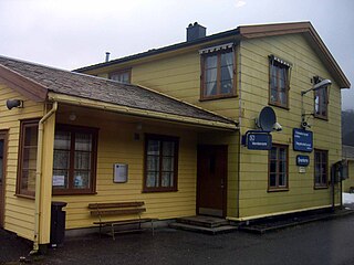
Snartemo Station is a railway station of the Sørlandet Line situated in the village of Snartemo in Hægebostad municipality in Agder county, Norway. Located 428.85 kilometers (266.48 mi) from Oslo Central Station, the station is situated on a 950-meter (3,120 ft) embankment between the Hægebostad Tunnel and the Kvineshei Tunnel.
Agder Kollektivtrafikk AS is a public transport administrator for the county of Agder, Norway.

Vågsbygd is a borough and district in the city of Kristiansand which lies in the municipality of Kristiansand in Agder county, Norway. It is the largest borough and district in Kristiansand. Until 1965, Vågsbygd was a part of Oddernes municipality. The borough includes the districts of Flekkerøy, Voiebyen, Vågsbygd/Augland, and Slettheia. The Kristiansand Cannon Museum on Kroodden is an authentic fortress from World War II.

Tinnheia is a district in the city of Kristiansand in Agder county, Norway. The population is around 3,660 (2014). It is part of the borough of Grim, and it is generally populated with mostly apartment homes, with a high percentage of immigrants. West of Tinnheia is the district of Hellemyr, to the east is the district of Grim (centrum), and to the south is the district of Slettheia.

Lund is a borough and district in the city of Kristiansand which lies in the municipality of Kristiansand in Agder county, Norway. It is the second largest borough in the city after Vågsbygd. In 2015, the population was about 30,000. Lund is divided into 4 districts: Lund (centrum), Gimlekollen, Justvik, and Ålefjær.
Sørlandsparken is a power center in the municipality of Kristiansand in Agder county, Norway. The park covers an area of about 670,000 square metres and it has over 5,000 work positions. The park area is located just off the European route E18 highway in the district of Tveit and it includes Norway's largest shopping mall, Sørlandssenteret as well as the Kristiansand Zoo and Amusement Park.

Vestre Strandgate is a street and a road in Kristiansand, Norway. The road is a part of National Road 471 and starts after Riksvei 9 ends in Kvadraturen.
Åsane is a neighbourhood in the city of Kristiansand in Agder county, Norway. The neighborhood is located in the borough of Vågsbygd and in the district of Vågsbygd. The Åsane Elementary School serves the neighborhood. Åsane is north of Bråvann, south of Nordtjønnåsen, and west of Bjørklia.
Karuss is a neighbourhood in the city of Kristiansand in Agder county, Norway. It is located in the borough of Vågsbygd and in the district of Slettheia. Karuss is northwest of Kjerrheia, southwest of Gislemyr, west of Trekanten, and east of Nordtjønnåsen.
Hasselbakken is a neighbourhood in the city of Kristiansand in Agder county, Norway. It is located in the borough of Vågsbygd and in the district of Vågsbygd. Hasselbakken is north of Bjørklia, south of Nordtjønnåsen, and west of Åsane.
Kjosneset is a neighbourhood in the city of Kristiansand in Agder county, Norway. It is located in the borough of Vågsbygd and in the district of Vågsbygd. Kjosneset is north of Smiebrygga, south of Auglandskollen, east of Kjos Haveby and west of Storenes.
Smiebrygga is a neighbourhood in the city of Kristiansand in Agder county, Norway. It is located in the borough of Vågsbygd and in the district of Vågsbygd. Smiebrygga is north of Kjosbukta, south of Auglandskollen, east of Kjosneset, and west of the ocean.
Storenes is a neighbourhood in the city of Kristiansand in Agder county, Norway. It is located in the borough of Vågsbygd and in the district of Vågsbygd. The neighborhood is located along the Kristiansandsfjorden, southeast of Augland.
Vestheiene is a neighbourhood in the city of Kristiansand in Agder county, Norway. It is located in the borough of Grim and in the district of Hellemyr. Vestheiene is located to the east of Breimyr and west of Hellemyrtoppen. Solkollen lies to the north of Vestheiene.
Hellemyrtoppen is a neighbourhood in the city of Kristiansand in Agder county, Norway. It is located in the borough of Grim and in the district of Hellemyr. Hellemyrtoppen is located just north of the European route E39 highway. It is north of Rige, east of Vestheiene, and west of Fjellro.
Solkollen is a neighbourhood in the city of Kristiansand in Agder county, Norway. It is located in the borough of Grim and in the district of Hellemyr. Solkollen is located to the north of Breimyr, to the west of the lake Eigevann, and to the north of Vestheiene.

Markens gate is the main pedestrian street in Kristiansand, Norway. It is located in the west of the borough Kvadraturen and the length of the entire street is 1 kilometer, while the pedestrian part is 550 meters and another 160 meters with Otterdalsparken. The streets goes from Slottet Mall in the north and is a pedestrian street all the way down to Dronningens gate, it's only crossed by traffic from Tordenskjolds gate, Kristian IVs gate and Henrik Wergelands gate before Dronningens gate. The pedestrian parts stretches over 7 quarters. Compared to other Norwegian cities, Markens street is one of the most walked streets in the country.


