Aust-Agder was one 18 counties (fylker) in Norway up to 1 January 2020, when it was merged with Vest-Agder to form Agder county. In 2002, there were 102,945 inhabitants, which was 2.2% of Norway's population. Its area was 9,212 square kilometres (3,557 sq mi). The county's administrative center was the town of Arendal.

Froland is a municipality in Agder county, Norway. It is part of the traditional region of Sørlandet. The administrative center is the village of Blakstad, which along with Osedalen form the main population center of the municipality. Other villages in Froland include Bøylefoss, Bøylestad, Froland, Frolands verk, Heldalsmo, Hinnebu, Hynnekleiv, Jomås, Lauvrak, Libru, Løvjomås, Mjåvatn, Mjølhus, Mykland, and Risdal.

Lillesand is municipality in Agder county, Norway. It is part of the traditional district of Sørlandet. The administrative center of the municipality is the town of Lillesand. Some of the larger villages in Lillesand municipality include Åkerøyhamn, Brekkestø, Gamle Hellesund, Helldal, Høvåg, Ribe, Skottevik, Trøe, Ulvøysund, and Vesterhus.

Birkenes is a municipality in Agder county, Norway. It is located in the traditional district of Sørlandet. The administrative centre of the municipality is the village of Birkeland, where about half the municipal population lives. Other villages in Birkenes include Ås, Engesland, Flakk, Håbbesland, Herefoss, Mollestad, Oggevatn, Rugsland, Senumstad, Søre Herefoss, Svaland, Tveide, and Væting.
Evje og Hornnes is a municipality in Agder county, Norway. It is located in the traditional district of Setesdal. The administrative centre of the municipality is the village of Evje. Other villages in the municipality include Åneland, Dåsnesmoen, Flatebygd, Gautestad, Hornnes, Kjetså, and Øvre Dåsvatn. Evje og Hornnes was created as a new municipality on 1 January 1960 after the merger of the two older municipalities of Evje and Hornnes. The Norwegian National Road 9 runs north–south through the municipality, along the river Otra.

Kristiansand Region is a statistical metropolitan region in the counties of Vest-Agder and Aust-Agder in southern Norway. It is centered on the city of Kristiansand. The region consist of 6 municipalities in the centre of Southern Norway. Vennesla, Songdalen, and Birkenes are inland municipalities while Kristiansand, Søgne, and Lillesand are coastal municipalities. Kristiansand is the largest municipality in population in the region and Birkeland is the largest in area.

Tovdalselva is 143 kilometres (89 mi) long and is one of the longest rivers in Southern Norway. The river flows through Agder county from the mountains on the northeast side of the Setesdal valley in Valle municipality southwards, until it reaches the sea at the Tofdalsfjorden between Hamresanden and Kjevik in Kristiansand. The upper reaches of the river include many lakes such as the Herefossfjorden and the Straumsfjorden. It drains about 1,800 square kilometres (690 sq mi) in territory and the highest point in the watershed is 1,101 metres (3,612 ft) above sea level. The drainage basin includes parts or all of the following municipalities: Fyresdal, Valle, Bygland, Evje og Hornnes, Åmli, Froland, Grimstad, Birkenes, Iveland, Lillesand, and Kristiansand.

Herefoss is a village in Birkenes municipality in Agder county, Norway. The village is located on the northeastern end of the Herefossfjorden which is a large lake on the river Tovdalselva. The Norwegian National Road 41 runs through the village connecting it to Søre Herefoss, about 8 kilometres (5.0 mi) to the south, and to Hynnekleiv in Froland, about 10 kilometres (6.2 mi) to the north. The lake Uldalsåna lies about 2 kilometres (1.2 mi) to the northwest.
Flaksvatn, formerly Flaksvand, is a village in Birkenes municipality in Agder county, Norway. Located just north of the village of Birkeland on the lake Flakksvann, the village was from 1896 to 1953 the terminus of the Lillesand–Flaksvand Line.

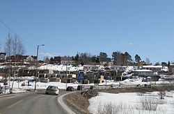
Håbbesland is a village in Birkenes municipality in Agder county, Norway. The village is located about 5 kilometres (3.1 mi) to the northeast of the municipal centre of Birkeland.
Mollestad is a village in Birkenes municipality in Agder county, Norway. The village is located on both sides of the river Tovdalselva, just south of the municipal centre of Birkeland. The Birkenes Church is located in eastern Mollestad (Østre Mollestad). The Norwegian National Road 41 runs through the village. The village of Rugsland lies to the south, Svaland lies to the west, and Tveide lies to the east.

Sennumstad or Senumstad is a village in Birkenes municipality in Agder county, Norway. The village is located on the western shore of the river Tovdalselva at the junction of the Norwegian National Road 41 and the Norwegian County Road 406. The Senumstad Bridge crosses the river in the village. The nearby village of Væting lies about 5 kilometres (3.1 mi) to the northwest, the village of Søre Herefoss lies about 5 kilometres (3.1 mi) to the north, and the municipal centre of Birkeland lies about 10 kilometres (6.2 mi) to the south.
Svaland is a village in Birkenes municipality in Agder county, Norway. The village is located in a very rural area about 10 kilometres (6.2 mi) southwest of the village of Birkeland and about the same distance northeast of the village of Vennesla.
Tveide is a village in Birkenes municipality in Agder county, Norway. The village is located about 3 kilometres (1.9 mi) south of the municipal centre of Birkeland. Historically, there was a railway station here along the now-closed Lillesand-Flaksvand Line.

Norwegian National Road 41 is a Norwegian national road that runs through Vestfold og Telemark and Agder counties in Norway. The road runs between the village of Brunkeberg in Kviteseid municipality in Vestfold og Telemark county in the north and Timenes in Hånes in the city of Kristiansand in Agder county in the south. The 172.9-kilometre (107.4 mi) long road connects to the European route E134 highway in the north and to the European route E18 highway in the south. The road runs for 101.5 kilometres (63.1 mi) in Agder county and 71.4 kilometres (44.4 mi) in Vestfold og Telemark county. The southern half of the road runs along the river Tovdalselva and the lake Herefossfjorden, and it is located in a fault zone called the Kristiansand-Porsgrunn grabenen.
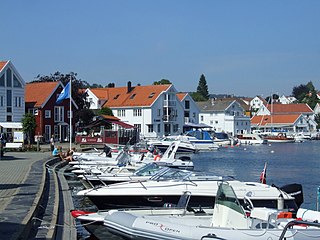
Lillesand is the administrative centre of Lillesand municipality in Agder county, Norway. The town is located along the Skaggerak coast, about 18 kilometres (11 mi) southwest of the town of Grimstad and about 25 kilometres (16 mi) northeast of the city of Kristiansand. The 5.03-square-kilometre (1,240-acre) town has a population (2016) of 7,530 which gives the town a population density of 1,497 inhabitants per square kilometre (3,880/sq mi).

Høvåg is a village in Lillesand municipality in Agder county, Norway. The village is located about 12 kilometres (7.5 mi) southwest of the town of Lillesand and about 15 kilometres (9.3 mi) northeast of the city of Kristiansand. The village lies on the northern shore of the Kjerkekilen, a strait leading from the Blindleia to the Isefjorden. The village is the site of Høvåg Church and from 1865 until 1962, it was the administrative centre of the old municipality of Høvåg.
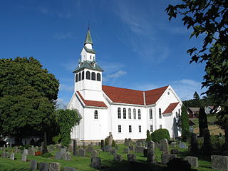
Birkenes Church is a parish church in Birkenes municipality in Agder county, Norway. It is located in the village of Mollestad, about 3.5 kilometres (2.2 mi) southwest of the municipal centre of Birkeland. The church is part of the Birkenes parish in the Vest-Nedenes deanery in the Diocese of Agder og Telemark. The white, wooden church was built in a cruciform style in 1858 by the architect Christian Heinrich Grosch. It was constructed on the same site as the previous church. The present church seats about 650 people. It was consecrated on 1 December 1858 by the Bishop Jacob von der Lippe.

Herefoss is a former municipality in Aust-Agder county, Norway. The municipality existed from 1838 until its dissolution in 1967 when it was merged into Birkenes municipality. Herefoss was a 148-square-kilometre (57 sq mi) area surrounding the Herefossfjorden. The administrative centre was the village of Herefoss where the Herefoss Church is located. The other main village was Søre Herefoss, located in the southern part of the municipality.

Mykland is a former municipality in Aust-Agder county, Norway. The 306-square-kilometre (118 sq mi) municipality existed from 1876 until 1967 when it was merged into the neighboring municipality of Froland. Mykland included the inland areas between the rivers Tovdalsåna and the Rettåna. The administrative centre was the village of Mykland where the Mykland Church is located.