
Kristiansand Region is a statistical metropolitan region in the counties of Vest-Agder and Aust-Agder in southern Norway. It is centered on the city of Kristiansand. The region consist of 6 municipalities in the centre of Southern Norway. Vennesla, Songdalen, and Birkenes are inland municipalities while Kristiansand, Søgne, and Lillesand are coastal municipalities. Kristiansand is the largest municipality in population in the region and Birkeland is the largest in area.

Southern Norway is the geographical region (landsdel) along the Skagerrak coast of southern Norway. The region is an informal description since it does not have any governmental function. It roughly corresponds to the old petty kingdom of Agder as well as the two present-day counties of Vest-Agder and Aust-Agder. The total combined area of Vest-Agder and Aust-Agder counties is 16,493 square kilometres (6,368 sq mi). The name is relatively new, having first been used in Norway around 1900.

The Diocese of Agder og Telemark is a diocese of the Church of Norway, covering the counties of Telemark, Aust-Agder, and Vest-Agder in Norway. The cathedral city is Kristiansand, Norway's fifth largest city. Kristiansand Cathedral serves as the seat of the presiding Bishop. The bishop since 2013 has been Stein Reinertsen. As of 1 January 2003, there were 347,324 members of the Church of Norway in the diocese.

Vollevannet is a freshwater is a lake in the municipality of Kristiansand in Vest-Agder county, Norway. The 0.15-square-kilometre (37-acre) lies in the district of Gimlekollen in the borough of Lund, and the surrounding residential area is also called Vollevannet. The lake lies along the European route E18 highway at the exit for the Vest-Agder Museum Kristiansand and Ålefjær. Historically, the lake was used as a reservoir for the city's drinking water. The lake is held back by two dams, and there is a small, sandy beach at the northeast end of the lake. The lake has perch in it.

Vågsbygd is a borough and district in the city of Kristiansand in Vest-Agder county, Norway. It is the largest borough and district in Kristiansand. Until 1965, Vågsbygd was a part of Oddernes municipality. The borough includes the districts of Flekkerøy, Voiebyen, Vågsbygd/Augland, and Slettheia. The Kristiansand Cannon Museum on Kroodden is an authentic fortress from World War II.
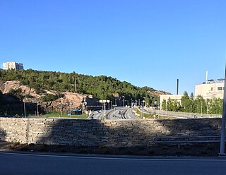
Hannevika or Hannevig / Hannevik is a neighbourhood in the city of Kristiansand in Vest-Agder county, Norway. It is located in the borough of Grim and in the district of Tinnheia. The neighborhood is located along the European route E39 highway and the start of Norwegian County Road 456. Hannevika is a large industrial area. Glencore and Hennig-Olsen Iskremfabrikk are the two largest industries located there. Hannevika is located southeast of Eigevannskollen, northeast of Kartheia, and south of Kolsberg.
Kolsberg is a neighbourhood in the city of Kristiansand in Vest-Agder county, Norway. It is located in the borough of Grim. The apartments at Kolsberg in the hills can be seen from the European route E39 highway passing to the south.

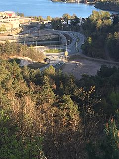
Rona is a neighborhood in the city of Kristiansand in Vest-Agder county, Norway. It is a part of the Oddernes borough and the district of Søm. The neighbourhood is next to European route E18, and spans the Indre Rona strait between Drangsvatna lake and the Topdalsfjorden. The neighborhood of Strømsdalen lies to the north and Strømme lies to the south. The closest school is Strømme Elementary school. All local bus lines goes through Rona.
Kartheia is a neighbourhood in the city of Kristiansand in Vest-Agder county, Norway. It is located in the northern part of the borough of Vågsbygd and in the district of Slettheia. The neighborhood lies southwest of the junction of the European route E39 highway and the County Road 456. The district of Hellemyr lies to the north. Kartheia contains residential areas as well as a large industrial area. Gislemyr lies to the south, Trane lies to the west, and Hannevika lies to the east.

Gimle is a neighbourhood in the city of Kristiansand in Vest-Agder county, Norway. It's located in the borough of Lund. It is located near the neighborhoods of Oddemarka and Presteheia. The neighborhood of Kjøita lies to the southwest and the neighborhood of Marvika lies to the southeast.
Eigevannskollen is a neighbourhood in the city of Kristiansand in Vest-Agder county, Norway. It is located in the borough of Grim and in the district of Tinnheia. It is located south of the lake Eigevann in Tinnheia and next to Hellemyr. Eigevann is north of the European route E39 highway and the neighbourhood is west of Hannevikåsen.
Gislemyr is a neighbourhood in the city of Kristiansand in Vest-Agder county, Norway. It is located in the borough of Vågsbygd and in the district of Slettheia. Gislemyr is north of Karuss, and south of Trane, and west of Blørstad and Fiskåtangen.
Trane or Rugde is a neighbourhood in the city of Kristiansand in Vest-Agder county, Norway. It is located in the northern part of the borough of Vågsbygd and in the district of Slettheia. Trane/Rugde is northwest of Gislemyr, north of Nedre Slettheia, south of Rige, and east of Øvre Slettheia.
Hellemyrtoppen is a neighbourhood in the city of Kristiansand in Vest-Agder county, Norway. It is located in the borough of Grim and in the district of Hellemyr. Hellemyrtoppen is located just north of the European route E39 highway. It is north of Rige, east of Vestheiene, and west of Fjellro.
Fidjemoen is a neighbourhood in the city of Kristiansand in Vest-Agder county, Norway. It is located in the borough of Grim and in the district of Hellemyr. It is located on the north side of the European route E39 highway. It lies at the western side of the district, west of Vestheiene and south of Solkollen.
Korsvik is an urban area in Kristiansand municipality in Vest-Agder county, Norway. The urban area is located on the east side of the Topdalsfjorden, about 9km east of the city center of Kristiansand. It is located in the districts of Søm and Randesund, south of the European route E18 highway and the Varodd Bridge. The 7.22-square-kilometre (1,780-acre) village has a population (2016) of 16,820 which gives the village a population density of 2,330 inhabitants per square kilometre (6,000/sq mi).

Gillsvannet or Gjelsvannet is a freshwater lake in the municipality of Kristiansand in Vest-Agder county, Norway. The 1.05-square-kilometre (260-acre) lake is located about 5 kilometres (3.1 mi) northeast of downtown Kristiansand, along to County Road 452. The lake lies about 300 metres (980 ft) west of the Topdalsfjorden, at an elevation of about 1 metre above sea level. There is a practice range for kayaking on the lake as well as many areas used for swimming during the summer season. The Gimlekollen district lies on the southern shore of the lake and the village of Justvik lies just north of the lake.


