District Justvik Gjusvik | |
---|---|
Village and District | |
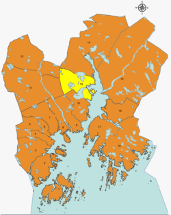
Map of Kristiansand with Justvik district highlighted in yellow | |
Coordinates: 58°11′49″N8°01′52″E / 58.1969°N 08.0311°E Coordinates: 58°11′49″N8°01′52″E / 58.1969°N 08.0311°E | |
Country | Norway |
Region | Southern Norway |
County | Vest-Agder |
Municipality | Kristiansand |
Borough | Lund |
Elevation | 5 m (16 ft) |
Population (2014) | |
• Total | 2,770 |
Time zone | UTC+01:00 (CET) |
• Summer (DST) | UTC+02:00 (CEST) |
ISO 3166 code | NO-030112 |
Website | kristiansand.kommune.no |
Justvik or Gjusvik is a village and district in the municipality of Kristiansand in Vest-Agder county, Norway. Its population (as of January 2014) is 2,770. The village of Justvik is located on the west shore of the Topdalsfjorden, just north of the lake Gillsvannet.
Before the large municipal merger with Kristiansand in 1965, the Justvik area was part of the old municipality of Tveit, while the Justnes and Eidsbukta areas immediately to the south belonged to Oddernes municipality.
Justvik has both older housing and several housing estates which were built during the economic boom from the mid-1960s to the mid-1980s. Within the village is Justvik Church, Justvik School (for elementary and middle school students), sports facilities, and a grocery store.
There are several neighborhoods within the district of Justvik: Bleget, Greppestølåsen, Justneshalvøya, Justvik, Jærnesheia, and Kvernhusheia.
The 10 largest political parties in Justvik as of the 2015 election: [2]
Kristiansand city council parties | Votes |
---|---|
Labour Party | 28,7% (325 votes) |
Conservative Party | 20,3% (230 votes) |
Christian Democratic | 17% (193 votes) |
Progress Party | 11,8% (55 votes) |
Green Party | 4,9% (55 votes) |
Liberal Party | 4,8% (54 votes) |
The Democrats | 4,7% (53 votes) |
Socialist Left Party | 2,7% (31 votes) |
Pensioners' | 2,1% (24 votes) |
Red | 1,1% (13 votes) |
Others | 2,2% (13 votes) |
Total | 1046 votes |
Line | Destination [3] |
---|---|
22 | Jærnesheia-Gimlekollen - Kvadraturen |
22 | Ålefjær-Gimlekollen - Kvadraturen |
23 | Jærnesheia-Vollevannet - Kvadraturen |
23 | Ålefjær-Vollevannet - Kvadraturen |
29 | Ålefjær - Justvik |
Vest-Agder[ˈvɛ̂stˌɑɡdər](
Vennesla is a municipality in Agder county, Norway. It is located in the traditional district of Sørlandet. The administrative centre of the municipality is the village of Vennesla. Other villages in Vennesla include Grovane, Hægeland, Homstean, Mushom, Øvre Eikeland, Øvrebø, Røyknes, and Skarpengland. Vennesla lies about 17 kilometres (11 mi) north of the city of Kristiansand in the Otra river valley.
Kristiansand, historically spelled Christianssand and Christiansand, is a city and municipality in Agder county, Norway. It is the fifth largest city in Norway and the municipality is the sixth largest in Norway, with a population of around 112,000 as of January 2020, following the incorporation of the municipalities of Søgne and Songdalen into the new and revised municipality of greater Kristiansand. In addition to the city itself, Statistics Norway counts four other densely populated areas in the municipality: Skålevik in Flekkerøy with a population of 3,526 in the Vågsbygd borough, Strai with a population of 1,636 in the Grim borough, Justvik with a population of 1,803 in the Lund borough, and Tveit with a population of 1,396 in the Oddernes borough. Kristiansand is divided into five boroughs: Grim, which is located northwest in Kristiansand with a population of 15,000; Kvadraturen, which is the centre and downtown Kristiansand with a population of 5,200; Lund, the second largest borough; Søgne, with a population of around 12,000 and incorporated into the municipality of Kristiansand as of January 2020; Oddernes, a borough located in the west; and Vågsbygd, the largest borough with a population of 36,000, located in the southwest.
Kristiansand Region is a statistical metropolitan region in the counties of Vest-Agder and Aust-Agder in southern Norway. It is centered on the city of Kristiansand. The region consist of 6 municipalities in the centre of Southern Norway. Vennesla, Songdalen, and Birkenes are inland municipalities while Kristiansand, Søgne, and Lillesand are coastal municipalities. Kristiansand is the largest municipality in population in the region and Birkeland is the largest in area.
Southern Norway is the geographical region (landsdel) along the Skagerrak coast of southern Norway. The region is an informal description since it does not have any governmental function. It roughly corresponds to the old petty kingdom of Agder as well as the two former counties of Vest-Agder and Aust-Agder. From New Year 2020, the two counties have been merged into one county, Agder. The total combined area of Vest-Agder and Aust-Agder counties is 16,493 square kilometres (6,368 sq mi). The name is relatively new, having first been used in Norway around 1900.
Tveit is a village and surrounding district in Oddernes borough in the city of Kristiansand in Agder county, Norway. The Tveit district is located in the northeastern part of Kristiansand, northeast of the Topdalsfjorden along the lower part of the Tovdalselva river. Tveit is the site of the main airport for Southern Norway: Kristiansand Airport, Kjevik. The district was the separate municipality of Tveit from 1838 until it was merged into Kristiansand in 1965.
Randesund is a village and district within the city of Kristiansand in Vest-Agder county, Norway. The district is located within the borough of Oddernes along the southern coastline between Kvåsefjorden and the Topdalsfjorden and south of the districts of Søm and Hånes. There are several small islands that are just off the coast in Randesund, including Dvergsøya, Randøya, and Herøya, all popular tourists destinations. The village of Randesund is located in the central part of the district and it is the site of Randesund Church. There was a separate municipality of Randesund that existed from 1893 until 1965.
Vollevannet is a freshwater lake in the municipality of Kristiansand in Agder county, Norway. The 0.15-square-kilometre (37-acre) lies in the district of Gimlekollen in the borough of Lund, and the surrounding residential area is also called Vollevannet. The lake lies along the European route E18 highway at the exit for the Vest-Agder Museum Kristiansand and Ålefjær. Historically, the lake was used as a reservoir for the city's drinking water. The lake is held back by two dams, and there is a small, sandy beach at the northeast end of the lake. The lake has perch in it.
Vågsbygd is a borough and district in the city of Kristiansand in Vest-Agder county, Norway. It is the largest borough and district in Kristiansand. Until 1965, Vågsbygd was a part of Oddernes municipality. The borough includes the districts of Flekkerøy, Voiebyen, Vågsbygd/Augland, and Slettheia. The Kristiansand Cannon Museum on Kroodden is an authentic fortress from World War II.
Hellemyr is a district in the city of Kristiansand in Vest-Agder county, Norway. It has a population of 2,990. The district is located in the borough of Grim. The district of Tinnheia lies to the east, the district of Slettheia lies to the south, the district of Grim lies to the north, and the municipality of Songdalen lies to the west. Hellemyr is the last district to drive through before exiting Kristiansand via the European route E39 highway.
Lund is a borough and district in the city of Kristiansand in Vest-Agder county, Norway. It is the second largest borough in the city after Vågsbygd. In 2015, the population was about 30,000. Lund is divided into 4 districts: Lund (centrum), Gimlekollen, Justvik, and Ålefjær.
Voiebyen is a district in the city of Kristiansand in Vest-Agder county, Norway. The district has a population of about 6,000 people in 2014 and it is a part of the borough of Vågsbygd in the southwestern part of the city. The district of Vågsbygd lies to the north, and the district of Flekkerøy lies to the south on the island of Flekkerøya.
Kvadraturen is the city center of Kristiansand in Vest-Agder county, Norway, with a population of 6,750 (2015). The borough is made up of the centre together with the harbour to the south and the more rural district of "Eg" to the north. Kvadraturen is the administrative centre of the municipality of Kristiansand as well as the administrative centre of Vest-Agder county, but is far smaller in area than the other boroughs in the municipality, such as the borough of Grim to the north and west, and the borough of Lund to the east.
Ålefjær is a village and district in the municipality of Kristiansand in Vest-Agder county, Norway. The village and district lies in the far northern part of the municipality within the borough of Lund. The population of the district in 2014 was 410. Ålefjær borders the district of Tveit to the southeast, the district of Justvik to the southwest, the municipality of Vennesla to the northwest, and the municipality of Birkenes to the northeast. The village of Ålefjær is situated at the northern end of the Ålefjærfjorden, a branch off the Topdalsfjorden. The district is a very rural area, although it is only about 5 kilometres (3.1 mi) southeast of the large village of Vennesla and about 10 kilometres (6.2 mi) north of the city of Kristiansand.
Korsvik is an urban area in Kristiansand municipality in Vest-Agder county, Norway. The urban area is located on the east side of the Topdalsfjorden, about 9 km east of the city center of Kristiansand. It is located in the districts of Søm and Randesund, south of the European route E18 highway and the Varodd Bridge. The 7.22-square-kilometre (1,780-acre) village has a population (2016) of 16,820 which gives the village a population density of 2,330 inhabitants per square kilometre (6,000/sq mi).
Mandal is the administrative centre of Mandal municipality in Vest-Agder county, Norway. It is the second largest town by population in Vest-Agder county after Kristiansand and the fourth largest town in the Sørlandet/Agder region. The town is located at the mouth of the river Mandalselva at the southern end of the Mandalen valley. The 6.32-square-kilometre (1,560-acre) town has a population (2015) of 10,725 which gives the town a population density of 1,697 inhabitants per square kilometre (4,400/sq mi).
Oddernes is a former municipality in Vest-Agder county, Norway. The 103-square-kilometre (40 sq mi) municipality existed from 1838 until its dissolution in 1964. The administrative centre was the village of Lund on the east side of the river Otra near where Lund Church is located. The former area of the municipality makes up the western part of the municipality of Kristiansand. It encircled the town of Kristiansand, and it included the villages such as Flekkerøy, Vågsbygd, Slettheia, Lund, Strai, Mosby, and Justvik. Today, the town of Kristiansand has a borough named Oddernes, but it has very different boundaries than the old municipality had.
Justvik Church is a parish church in Kristiansand municipality in Agder county, Norway. It is located in the village of Justvik, just north of the city centre of Kristiansand. The church is part of the Oddernes parish in the Kristiansand arch-deanery in the Diocese of Agder og Telemark. The tan brick church was built in 1996 using plans by the architect Ernst Aukland. The church seats about 275 people.
This Agder location article is a stub. You can help Wikipedia by expanding it. |