Vest-Agder was one of 18 counties (fylker) in Norway up until 1 January 2020, when it was merged with Aust-Agder to form Agder county. In 2016, there were 182,701 inhabitants, around 3.5% of the total population of Norway. Its area was about 7,277 square kilometres (2,810 sq mi). The county administration was located in its largest city, Kristiansand.

Vennesla is a municipality in Agder county, Norway. It is located in the traditional district of Sørlandet. The administrative centre of the municipality is the village of Vennesla. Other villages in Vennesla include Grovane, Hægeland, Homstean, Mushom, Øvre Eikeland, Øvrebø, Røyknes, and Skarpengland. Vennesla lies about 17 kilometres (11 mi) north of the city of Kristiansand in the Otra river valley.

Songdalen is a former municipality in the old Vest-Agder county, Norway. The municipality existed from 1964 until 2020 when it was merged with Søgne and Kristiansand municipalities to form a new, much larger Kristiansand municipality in what is now Agder county. It was located in the traditional district of Sørlandet, just outside of the city of Kristiansand. The administrative centre of the municipality was the village of Nodeland. Other villages in the municipality included Brennåsen, Finsland, Kilen, Nodelandsheia, and Volleberg. The Sørlandsbanen railway line ran through the municipality, stopping at Nodeland Station. The European route E39 highway also ran through the southern part of the municipality.

Kristiansand is a city and municipality in Agder county, Norway. The city is the fifth-largest and the municipality is the sixth-largest in Norway, with a population of around 116,000 as of January 2020, following the incorporation of the municipalities of Søgne and Songdalen into the greater Kristiansand municipality. In addition to the city itself, Statistics Norway count four other densely populated areas in the municipality: Skålevik in Flekkerøy with a population of 3,526 in the Vågsbygd borough, Strai with a population of 1,636 in the Grim borough, Justvik with a population of 1,803 in the Lund borough, and Tveit with a population of 1,396 in the Oddernes borough. Kristiansand is divided into five boroughs; -Grim, which is located northwest in Kristiansand with a population of 15,000; Kvadraturen, which is the centre and downtown Kristiansand with a population of 5,200; Lund, the second largest borough; Søgne, with a population of around 12,000 and incorporated into the municipality of Kristiansand as of January 2020; Oddernes, a borough located in the west; and Vågsbygd, the largest borough with a population of 36,000, located in the southwest.
Southern Norway is the geographical region (landsdel) along the Skagerrak coast of southern Norway. The region is an informal description since it does not have any governmental function. It roughly corresponds to the old petty kingdom of Agder being coextensive with the county, as well as the two former counties of Vest-Agder and Aust-Agder. From New Year 2020, the two counties have been merged into one county, Agder. The total combined area of Vest-Agder and Aust-Agder counties is 16,493 square kilometres (6,368 sq mi). The name is relatively new, having first been used in Norway around 1900.
Volleberg is a village in Kristiansand municipality in Agder county, Norway. The village is located along the river Songdalselva, in former Songdalen municipality, right on the border with former Søgne municipality. The European route E39 highway passes by the village on its way from Nodeland and Brennåsen about 1 to 2 kilometres to the north and Tangvall about 3.5 kilometres (2.2 mi) to the south. The 0.32-square-kilometre (79-acre) village has a population (2016) of 560 which gives the village a population density of 1,750 inhabitants per square kilometre (4,500/sq mi). The village is primarily a residential community with people working in the nearby urban areas of Kristiansand and Søgne.
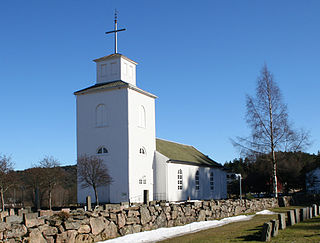
Greipstad is a former municipality in the old Vest-Agder county, Norway. The 104-square-kilometre (40 sq mi) municipality existed from 1913 until its dissolution in 1964 when it became part of Songdalen municipality. The administrative centre of the municipality was the village of Nodeland where the Greipstad Church is located. The municipality is located in the northern part of the present-day municipality of Kristiansand in Agder county.

Oddernes is a borough in the city of Kristiansand which lies in the municipality of Kristiansand in Agder county, Norway. The borough covers eastern Kristiansand on the east side of the Topdalsfjorden and the Varodd Bridge. The borough includes the former municipalities of Randesund and Tveit. There was a municipality of Oddernes from 1838 until 1965, but its boundaries were very different from those of the present-day borough.

Hægeland or Hægelandskrossen is a village in Vennesla municipality in Agder county, Norway. The village is located along the northeastern shore of the lake Hægelandsvatnet, a short distance south of the Kilefjorden. The Norwegian National Road 9 runs north-south through the village, just past Hægeland Church. The village of Bjelland lies about 15 kilometres (9.3 mi) to the east and the villages of Skarpengland and Øvrebø both lie about 15 kilometres (9.3 mi) to the south. The village of Øvre Eikeland lies about 2 kilometres (1.2 mi) southeast of Hægeland, along the Rv9 highway.

Kristiansand District Court was a district court in Agder county, Norway. The court was based in the town of Kristiansand. The court existed until 2021. It had jurisdiction over the southern part of the county which included the municipalities of Kristiansand, Bykle, Valle, Bygland, Evje og Hornnes, Iveland, Vennesla, Birkenes, Lillesand, Lindesnes, and Åseral. Cases from this court could be appealed to Agder Court of Appeal. This court employed a chief judge, 11 other judges, 4 assistant judges, and 23 prosecutors.

Vågsbygd is a borough and district in the city of Kristiansand which lies in the municipality of Kristiansand in Agder county, Norway. It is the largest borough and district in Kristiansand. Until 1965, Vågsbygd was a part of Oddernes municipality. The borough includes the districts of Flekkerøy, Voiebyen, Vågsbygd/Augland, and Slettheia. The Kristiansand Cannon Museum on Kroodden is an authentic fortress from World War II.

Grim is a borough in the city of Kristiansand which lies in the municipality of Kristiansand in Agder county, Norway. The borough has a population of about 16,000 people and is the second least populated borough in Kristiansand. Grim is located in the northwestern part of the municipality, north of Vågsbygd borough, northwest of Kvadraturen borough, and west of Lund borough. Grim also borders Songdalen and Vennesla municipalities to the west and north, respectively.

Lund is a borough and district in the city of Kristiansand which lies in the municipality of Kristiansand in Agder county, Norway. It is the second largest borough in the city after Vågsbygd. In 2015, the population was about 30,000. Lund is divided into 4 districts: Lund (centrum), Gimlekollen, Justvik, and Ålefjær.

Norwegian County Road 456 (Fv456) is a Norwegian county road in Agder, Norway. The road takes over for European route E39 in Hannevika, Kristiansand, in to the borough Vågsbygd. Therefore this part is called the Vågsbygdporten and goes through a tunnel under Slettheia. The road continues south through Vågsbygd and goes west when it comes to Voiebyen. It then goes past Bråvann and into Søgne municipality. In Søgne, the road goes through Langenes and is therefore called Langenesveien or Langenessletta. County Road 456 goes past places like the church in Søgne and the only high school in Søgne. The road ends in Søgne centrum, Tangvall. It leads through the centre and stops with E39 again.
40 / 42/50 are three local bus lines in Kristiansand, Norway to Søgne. They all go from downtown Kristiansand to the centrum of Søgne and further in the municipality. 40 and 42 goes all day and evening, while line 50 only goes in the rush hours. Line 40 goes ten past the hour and line 42 ten past half. There are extra buses in the rush hours.
Lunde is a village in Kristiansand municipality in Agder county, Norway. The village is located along the European route E39 highway and along the river Lundeelva. The village is surrounded by several other villages that together form the greater Søgne urban area. The village of Lohne lies about 2 kilometres (1.2 mi) to the west, Vedderheia lies about 1 kilometre (0.62 mi) to the north, Eig lies about 1 kilometre (0.62 mi) to the southeast, and Tangvall lies about 2 kilometres (1.2 mi) to the east. The village of Ausviga lies about 2 kilometres (1.2 mi) to the south, but it is not part of the greater Søgne urban area.
Brennåsen is a village in Kristiansand municipality in Agder county, Norway. The village is located along the river Songdalselva, about 2 kilometres (1.2 mi) southeast of the village of Nodeland and about 1.5 kilometres (0.93 mi) north of the village of Volleberg. The European route E39 highway passes through Brennåsen as it travels between the cities of Kristiansand and Stavanger. The village was part of Songdalen municipality prior to 2020 when that municipality was dissolved.
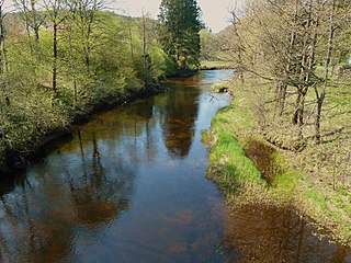
Songdalselva or Søgneelva or Songa is a river in Agder county, Norway. The 55.3-kilometre (34.4 mi) long river in the hills between Finsland in Kristiansand municipality and Hægeland in Vennesla municipality. The 209.4-square-kilometre (80.8 sq mi) catchment area is located between the Otra river and Mandalselva river watersheds. The river runs through the villages of Hortemo, Nodeland, Volleberg, Tangvall, Åros, and Høllen.

Agder District Court is a district court located in Agder county, Norway. This court is based at three different courthouses which are located in Farsund, Kristiansand, and Arendal. The court serves most of Agder county and includes cases from 24 municipalities. The courthouse in Farsund accepts cases from the municipalities of Farsund, Flekkefjord, Hægebostad, Kvinesdal, and Lyngdal. The courthouse in Kristiansand accepts cases from the municipalities of Birkenes, Bygland, Bykle, Evje og Hornnes, Iveland, Kristiansand, Lillesand, Lindesnes, Valle, Vennesla, and Åseral. The courthouse in Arendal accepts cases from the municipalities of Arendal, Froland, Gjerstad, Grimstad, Risør, Tvedestrand, Vegårshei, and Åmli. The court is subordinate to the Agder Court of Appeal.