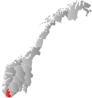
Vest-Agder was one of 18 counties (fylker) in Norway up until 1 January 2020, when it was merged with Aust-Agder to form Agder county. In 2016, there were 182,701 inhabitants, around 3.5% of the total population of Norway. Its area was about 7,277 square kilometres (2,810 sq mi). The county administration was located in its largest city, Kristiansand.

Kvinesdal is a municipality in Agder county, Norway. It is located in the traditional district of Lister. The administrative centre of the municipality is the village of Liknes. Other villages in Kvinesdal include Feda, Fjotland, and Storekvina.

Sirdal is a municipality in Agder county, Norway. It is located in the northwestern part of the traditional district of Lister. The administrative centre of the municipality is the village of Tonstad. Other villages in Sirdal include Bjørnestad, Haughom, Kvæven, Lunde, and Tjørhom.
Øyslebø is a village in Lindesnes municipality in Agder county, Norway. The village is located in the Mandalen valley along the Mandalselva river, about 21 kilometres (13 mi) north of the town of Mandal. The Sørlandet Line passes the village to the north, stopping at the Marnardal Station, about 5 kilometres (3.1 mi) north of Øyslebø on the north side of the village of Heddeland. Øyslebø was the administrative centre of the old municipality of Øyslebø which existed from 1899 until 1964.
Øvre Sirdal is a former municipality that was located in the old Vest-Agder county in Norway. The 1,156-square-kilometre (446 sq mi) municipality existed from 1905 until its dissolution in 1960. It was located in the northern part of the present-day municipality of Sirdal in Agder county. The administrative centre was the village of Lunde where Lunde Church is located.
Barbu is a former municipality in the old Aust-Agder county in Norway. Today, it is part of the is part of the town of Arendal in Agder county. The 15.3-square-kilometre (5.9 sq mi) municipality existed from 1878 until 1902 when it was merged into the town of Arendal. The municipality was located just to the north of what was then the 0.34-square-kilometre (84-acre) town of Arendal. The administrative centre of the small, urban municipality was called Barbu as well. Barbu Church was the church for the municipality.

Austad is a village in Lyngdal municipality in Agder county, Norway. The village is located in the southern part of Lyngdal, about 6 kilometres (3.7 mi) south of the town of Lyngdal and the village of Korshamn. The village is on the eastern shore of the Rosfjorden. The Austad Church is located in the center of the village. The village was the administrative centre of the old municipality of Austad which existed from 1909 until 1963. In the Rockstar produced game, “Red Dead Redemption 2”, Austad is referenced on a newspaper scrap found on one of the settlers of Manzanita Post.

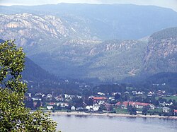
Fjotland is a village in Kvinesdal municipality in Agder county, Norway. The village is located in the northern part of the Kvinesdalen valley on the northeast side of the lake Fjotlandsvatnet. Fjotland is about 17 kilometres (11 mi) southeast of the village of Haughom in Sirdal and about 25 kilometres (16 mi) north of Liknes. Fjotland was the administrative centre of the old municipality of Fjotland which existed prior to 1963. Fjotland Church is located in the village.

Vigeland is a village in Lindesnes municipality in Agder county, Norway. The village is located along the river Audna, about 5 kilometres (3.1 mi) north of the river's mouth at the Snigsfjorden. The European route E39 highway runs east-west through Vigeland, connecting it to the town of Mandal, about 12 kilometres (7.5 mi) to the southeast. The 1.19-square-kilometre (290-acre) village has a population (2015) of 1,471 which gives the village a population density of 1,236 inhabitants per square kilometre (3,200/sq mi). Prior to 1 January 2020, the village was the administrative center of Lindesnes municipality.
Bjelland og Grindum is a former municipality in the old Vest-Agder county, Norway. The administrative centre of the municipality was the village of Bjelland where Bjelland Church is located. The 294-square-kilometre (114 sq mi) municipality existed from 1838 until 1902. It was located in the Mandalen valley in the northern parts of the present-day municipalities of Lyngdal and Lindesnes in what is now Agder county.
Øyslebø og Laudal is a former municipality in Vest-Agder county, that was located in the old Vest-Agder county in Norway. The 250-square-kilometre (97 sq mi) municipality existed from 1838 until 1899. The administrative centre was the village of Øyslebø. The municipality was located in part of the present-day municipality of Lindesnes in Agder county.
Øvrebø og Hægeland is a former municipality that was located in the old Vest-Agder county in Norway. The 303-square-kilometre (117 sq mi) municipality existed from 1865 until its dissolution in 1896. It was located in the northern part of the present-day municipality of Vennesla, to the west of the Otra river. The administrative centre of the municipality was the village of Øvrebø, where Øvrebø Church is located.

Nes og Hitterø or Hitterø og Nes is a former municipality that was located in the old Vest-Agder county in Norway. It was located in the southwestern part of the present-day municipality of Flekkefjord in Agder county. It encompassed the Nes peninsula and the island of Hidra. The 240-square-kilometre (93 sq mi) municipality existed from 1838 until its dissolution in 1893. The administrative centre of the municipality was the small village of Sunde in Nes parish, located just outside the town of Flekkefjord.

Lista is a former municipality located in the old Vest-Agder county in Norway. The 193-square-kilometre (75 sq mi) municipality existed from 1838 until its dissolution in 1965. The administrative centre was the village of Vanse where Vanse Church is located. Lista municipality was historically known as the municipality of Vanse until 1911. The former municipality's land is now located in the present-day municipality of Farsund in Agder county.

Hægeland or Hægelandskrossen is a village in Vennesla municipality in Agder county, Norway. The village is located along the northeastern shore of the lake Hægelandsvatnet, a short distance south of the Kilefjorden. The Norwegian National Road 9 runs north-south through the village, just past Hægeland Church. The village of Bjelland lies about 15 kilometres (9.3 mi) to the east and the villages of Skarpengland and Øvrebø both lie about 15 kilometres (9.3 mi) to the south. The village of Øvre Eikeland lies about 2 kilometres (1.2 mi) southeast of Hægeland, along the Rv9 highway.

Bakke is a former municipality in Vest-Agder county, Norway. The 244-square-kilometre (94 sq mi) municipality existed from 1838 until its dissolution in 1965. It was located in the present-day municipalities of Sirdal and Flekkefjord. It included the whole Sirdalen valley along the Rogaland county border, stretching from the Aust-Agder county border in the north to Sirnes and the lake Lundevatnet in the south. The administrative center was the village of Sira where Bakke Church is located.
Tonstad is a former municipality that was located in the old Vest-Agder county in Norway. The 361-square-kilometre (139 sq mi) municipality existed from 1905 until 1960. It encompassed the southern part of the present-day municipality of Sirdal. The administrative center of the municipality was the village of Tonstad where Tonstad Church is located.
Fjotland is a former municipality in the old Vest-Agder county, Norway. The 600-square-kilometre (230 sq mi) municipality existed from 1838 until 1841 and again from 1858 until its dissolution in 1963. The administrative centre was the village of Fjotland where Fjotland Church is located. The municipality covered the northern part of the Kvinesdalen valley in the present-day municipality of Kvinesdal.
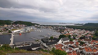
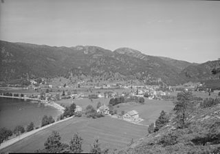
Mandal is a town in Lindesnes municipality in Agder county, Norway. Mandal is the fourth largest town in Agder as well as the administrative centre of Lindesnes municipality. It is located at the mouth of the river Mandalselva at the southern end of the Mandalen valley. The 6.63-square-kilometre (1,640-acre) town has a population (2019) of 11,053 and a population density of 1,667 inhabitants per square kilometre (4,320/sq mi). In Norway, Mandal is considered a by which can be translated as either a "town" or "city" in English.
Laudal is a former municipality located in the old Vest-Agder county in Norway. The 93-square-kilometre (36 sq mi) municipality existed from 1899 until 1964. The administrative centre of the municipality was the village of Laudal where Laudal Church is located. The municipality encompassed part of what is now the municipality of Lindesnes in Agder county.