
Lyngdal (help·info) is a municipality in Agder county, Norway. It is located in the traditional district of Lister. The administrative centre of the municipality is the town of Alleen. Some of the main villages in Lyngdal include Austad, Byremo,Fleseland, Hæåk, Konsmo, Korshamn, Kvås, Skomrak, Svenevik, and Vivlemo.

Arendal is a municipality in Agder county in southeastern Norway. Arendal belongs to the region of Sørlandet. The administrative centre of the municipality is the city of Arendal. Some of the notable villages in Arendal include Rykene, Eydehavn, Færvik, Strengereid, Kongshavn, Kilsund, Brattekleiv, Torsbudalen, Longum, Saltrød, Staubø, Vrengen, and Kolbjørnsvik. The offices of UNEP/GRID-Arendal are also located in the city of Arendal.

Risør (help·info) is a municipality in Agder county, Norway. It is located along the Skagerrak coast in the traditional region of Sørlandet. The administrative centre of Risør is the town of Risør. There are many villages in Risør such as Akland, Bossvika, Fie, Hødnebø, Krabbesund, Moen, Nipe, Røysland, Sandnes, Sivik, Søndeled, and Stamsø.

Grimstad is a municipality in Agder county, Norway. It belongs to the geographical region of Sørlandet. The administrative center of the municipality is the town of Grimstad. Some of the villages in Grimstad include Eide, Espenes, Fevik, Fjære, Håbbestad, Hesnes, Homborsund, Jortveit, Kroken, Landvik, Nygrenda, Prestegårdskogen, Reddal, Roresand, Rønnes, Skiftenes, Tjore, Vik, and Østerhus.

Tvedestrand (help·info) is municipality in Agder county, Norway. It is located in the traditional district of Sørlandet. The administrative center is the town of Tvedestrand. There are many villages in the municipality including Dypvåg, Fiane, Gjeving, Gødderstad, Grønland, Kilen, Klåholmen, Krokvåg, Laget, Lyngør, Nesgrenda, Østerå, Sagesund, Sandvika, and Songe.

Froland is a municipality in Agder county, Norway. It is part of the traditional region of Sørlandet. The administrative center is the village of Blakstad, which along with Osedalen form the main population center of the municipality. Other villages in Froland include Bøylefoss, Bøylestad, Froland, Frolands verk, Heldalsmo, Hinnebu, Hynnekleiv, Jomås, Lauvrak, Libru, Løvjomås, Mjåvatn, Mjølhus, Mykland, and Risdal.

Birkenes is a municipality in Agder county, Norway. It is located in the traditional district of Sørlandet. The administrative centre of the municipality is the village of Birkeland, where about half the municipal population lives. Other villages in Birkenes include Ås, Engesland, Flakk, Håbbesland, Herefoss, Mollestad, Oggevatn, Rugsland, Senumstad, Søre Herefoss, Svaland, Tveide, and Væting.

Dypvåg is a former municipality in the old Aust-Agder county, Norway. The 15-square-kilometre (5.8 sq mi) municipality existed from 1838 until its dissolution in 1960 when it was merged into the present-day municipality of Tvedestrand which is in Agder county. The small municipality included the coastal area about 8 kilometres (5.0 mi) east of the town of Tvedestrand and several islands located just offshore. The administrative centre was the village of Dypvåg where the Dypvåg Church is located.

Stokken is a former municipality in the old Aust-Agder county in Norway. The 11-square-kilometre (4.2 sq mi) municipality existed from 1919 until 1962 when it was merged into the newly-created Moland municipality. Today, the area is a part of the present-day municipality of Arendal in Agder county. The administrative centre of the municipality was the village of Eydehavn. The Stokken Church was the main church for the small municipality located just outside the town of Arendal.

Søndeled is a former municipality in the old Aust-Agder county in Norway. The 189-square-kilometre (73 sq mi) municipality existed from 1838 until its dissolution in 1964 when it was merged into the municipality of Risør in what is now Agder county. The municipality encompassed the land around the Søndeledfjorden. The administrative centre of Søndeled was the village of Søndeled at the innermost part of the Søndeledfjorden. Other villages in Søndeled included Stamsø, Akland, Moen, Bossvika, and Sivik. The main churches for Søndeled municipality were Indre Søndeled Church in the village of Søndeled and Ytre Søndeled Church in the east, just outside of the town of Risør.
Holt is a former municipality in the old Aust-Agder county in Norway. The 176-square-kilometre (68 sq mi) municipality existed from 1838 until its dissolution in 1960 when it was merged into the present-day municipality of Tvedestrand which is now in Agder county. The administrative centre of Holt was located just south of the village of Fiane where Holt Church is located.

Austre Moland is a former municipality in the old Aust-Agder county in Norway. The municipality existed from 1838 until 1962 when it was merged with several neighboring municipalities to form the new municipality of Moland. It is now part of the municipality of Arendal in Agder county. The administrative centre was at Brekka where the Austre Moland Church is located.

Øyestad is a former municipality in the old Aust-Agder county in Norway. The 96-square-kilometre (37 sq mi) municipality existed from 1838 until 1992 when it was merged into the present-day municipality of Arendal which is now located in Agder county. At the time of its dissolution, the municipality of Øyestad encompassed most of the coastline between the towns of Grimstad and Arendal, along with the forested areas along the Nidelva river heading inland. Back in 1838, however, the municipality was far larger in size. The administrative centre was the village of Bjorbekk near the Bjorbekk Church.

Nesgrenda is a village in Tvedestrand municipality in Agder county, Norway. The village is located along the Norwegian County Road 415 about 7 kilometres (4.3 mi) west of the town of Tvedestrand and about 1 kilometre (0.62 mi) northwest of the village of Fiane and the European route E18 highway. The Næs jernverk facility is located in the village.

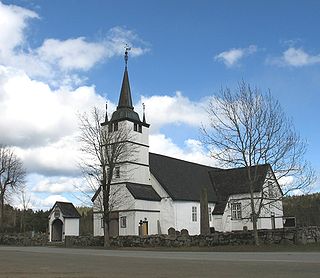
Gyland is a former municipality in the old Vest-Agder county, Norway. The 182-square-kilometre (70 sq mi) municipality was located in the northeastern part of the present-day municipality of Flekkefjord in what is now Agder county. The municipality existed very briefly from 1838 until 1839 and then it was re-created in 1893 and it existed until 1965. The administrative centre was the village of Gyland where Gyland Church is located.

Farsund (help·info) is the administrative centre of Farsund municipality in Agder county, Norway. The town is located near the mouth of the Lyngdalsfjorden, about 5 kilometres (3.1 mi) east of the village of Vanse. Frelserens Church is the main church for the town. The 2.96-square-kilometre (730-acre) town has a population (2019) of 3,377 and a population density of 1,140 inhabitants per square kilometre (3,000/sq mi). In Norway, Farsund is considered a by which can be translated as either a "town" or "city" in English.

Mandal is the administrative centre of Lindesnes municipality in Agder county, Norway. It is the fourth largest town in Agder. The town is located at the mouth of the river Mandalselva at the southern end of the Mandalen valley. The 6.32-square-kilometre (1,560-acre) town has a population (2015) of 10,725 which gives the town a population density of 1,697 inhabitants per square kilometre (4,400/sq mi).

Finsland is a former municipality in the old Vest-Agder county, Norway. The 118-square-kilometre (46 sq mi) municipality existed from 1838 until its dissolution in 1964. The administrative centre was the village of Finsland where Finsland Church is located. The municipality generally encompassed the northern part of the present-day municipality of Kristiansand in what is now Agder county.
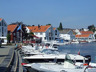
Risør is a town and the administrative centre of Risør municipality in Agder county, Norway. The town is located along the Skaggerak coast on a peninsula between the entrances to the Søndeledfjorden and the Sandnesfjorden. The town is one of the oldest towns in Southern Norway. It was declared a ladested in 1630 and upgraded to a kjøpstad in 1723. It sits about 20 kilometres (12 mi) southwest of the nearby coastal town of Kragerø and about the same distance northeast of the nearby coastal town of Tvedestrand. The nearest large town to Risør is the town of Arendal, about 40 kilometres (25 mi) to the southwest. The 2.92-square-kilometre (720-acre) town has a population (2019) of 4,609 and a population density of 1,580 inhabitants per square kilometre (4,100/sq mi).
Lillesand is the administrative centre of Lillesand municipality in Agder county, Norway. The town is located along the Skaggerak coast, about 18 kilometres (11 mi) southwest of the town of Grimstad and about 25 kilometres (16 mi) northeast of the city of Kristiansand. The 5.08-square-kilometre (1,260-acre) town has a population (2019) of 7,966 and a population density of 1,567 inhabitants per square kilometre (4,060/sq mi). In Norway, Lillesand is considered a by which can be translated as either a "town" or "city" in English.


