
Iveland is a municipality in Agder county, Norway. It is located in the traditional district of Setesdal. The administrative centre of the municipality is the village of Birketveit. Other villages in the municipality include Bakken, Skaiå, and Vatnestrøm.
Evje og Hornnes is a municipality in Agder county, Norway. It is located in the traditional district of Setesdal. The administrative centre of the municipality is the village of Evje. Other villages in the municipality include Åneland, Dåsnesmoen, Flatebygd, Gautestad, Hornnes, Kjetså, and Øvre Dåsvatn. Evje og Hornnes was created as a new municipality on 1 January 1960 after the merger of the two older municipalities of Evje and Hornnes. The Norwegian National Road 9 runs north–south through the municipality, along the river Otra.

Bygland is a municipality in Agder county, Norway. It is located in the traditional district of Setesdal. The administrative centre of the municipality is the village of Bygland. Other villages in the municipality include Åraksbø, Austad, Byglandsfjord, Grendi, Langeid, Lauvdal, Litveit, Longerak, Moi, Ose, Sandnes, Skåmedal, and Tveit. The Norwegian National Road 9 runs through the municipality, following the river Otra where most of the population of Bygland lives.

Valle is a municipality in Agder county, Norway. It is located in the traditional district of Setesdal. The administrative centre of the municipality is the village of Valle. Other villages in Valle include Besteland, Brokke, Homme, Hovet, Rygnestad, Rysstad, and Uppstad.
Setesdal is a valley and a traditional district in Agder County in southern Norway. It consists of the municipalities of Bykle, Valle, Bygland, Iveland, and Evje og Hornnes.

Tovdalselva is 143 kilometres (89 mi) long and is one of the longest rivers in Southern Norway. The river flows through Agder county from the mountains on the northeast side of the Setesdal valley in Valle municipality southwards, until it reaches the sea at the Tofdalsfjorden between Hamresanden and Kjevik in Kristiansand. The upper reaches of the river include many lakes such as the Herefossfjorden and the Straumsfjorden. It drains about 1,800 square kilometres (690 sq mi) in territory and the highest point in the watershed is 1,101 metres (3,612 ft) above sea level. The drainage basin includes parts or all of the following municipalities: Fyresdal, Valle, Bygland, Evje og Hornnes, Åmli, Froland, Grimstad, Birkenes, Iveland, Lillesand, and Kristiansand.

The Otra is the largest river in the Sørlandet region of Norway. It begins in Setesdalsheiene mountains at the lake Breidvatnet in Bykle municipality in Agder county, just south of the border with Vinje municipality in Vestfold og Telemark county. The river then flows south through Bykle, Valle, Bygland, Evje og Hornnes, Iveland, Vennesla, and Kristiansand municipalities. The river empties into the Skagerrak in the center of the city of Kristiansand on the southern coast of Norway.

Longerakvatnet or Longeraksvatnet is a lake in the municipality of Bygland in Agder county, Norway. It has a small dam on the southwest side to regulate the water level for hydro-electric power generation at a plant located down the hill. The lake discharges into the Longeraksåni river which flows into the Byglandsfjorden near the village of Longerak. The 3.4-square-kilometre (1.3 sq mi) lake is located about 6 kilometres (3.7 mi) southeast of the village of Lauvdal and about 10 kilometres (6.2 mi) northeast of the village of Byglandsfjord.
Kilefjorden is a lake on in Agder county, Norway. The lake is located on the border of the municipalities of Evje og Hornnes, Iveland, and Vennesla. The lake is part of the river Otra. The lake is located about 6 kilometres (3.7 mi) west of the village of Birketveit in Iveland, about 2.5 kilometres (1.6 mi) north of the village of Hægeland in Vennesla, and about 15 kilometres (9.3 mi) south of the village of Hornnes in Evje og Hornnes.
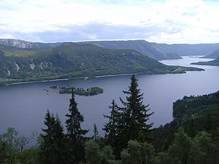
Gyvatn is a lake in Agder county, Norway. The lake straddles the borders of the three municipalities of Åseral, Bygland and Evje og Hornnes. The 4.62-square-kilometre (1.78 sq mi) lake is located about 8 kilometres (5.0 mi) northwest of the village of Byglandsfjord and the lake Byglandsfjorden and it is about 7 kilometres (4.3 mi) east of the village of Åknes in Åseral.
Homstølvatnet or Eptevatn is a lake in the far western part of the municipality of Froland in Agder county, Norway. It is located about 12 kilometres (7.5 mi) east of the village of Byglandsfjord (in Bygland municipality) and about 16 kilometres (9.9 mi) northwest of the village of Mykland in Froland. The lake was expanded in 1973 when a dam was built at the south end of the lake Eptevatn for the purposes of hydroelectric power generation. The dam made the lake larger so that it now includes the formerly separate lake Homstølvatnet as one large lake. The lake is now 3.92-square-kilometre (1.51 sq mi) large and it holds about 44 cubic megametres (3.6×10¹⁶ acre⋅ft) as a reservoir for the power station.
Høvringsvatnet or Høvringsvatn is a lake in the municipality of Evje og Hornnes in Agder county, Norway. It's located about 10 kilometres (6.2 mi) northeast of the village area of Evje and about 6 kilometres (3.7 mi) southeast of the village area of Byglandsfjord. The lake Homstølvatnet in Froland municipality is located about 5 kilometres (3.1 mi) to the northeast.
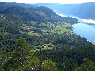
Byglandsfjorden is a lake in Agder county, Norway. The 32.79-square-kilometre (12.66 sq mi) lake lies on the river Otra, primarily in the municipality of Bygland, but the far southern tip of the lake extends into the neighboring municipality of Evje og Hornnes. The river flows out of the lake Åraksfjorden to the north and into the Byglandsfjorden through a narrow channel, and the southern end of the Byglandsfjorden is marked by a dam along the river. The villages of Byglandsfjord, Grendi, Longerak, Lauvdal, and Bygland are all located on the eastern shore of the lake along the Norwegian National Road 9. The western shore of the lake is much more sparsely populated, with County Road 304 following that shoreline.

Evje is a former municipality in Aust-Agder county, Norway. The municipality was located in what is now the eastern part of the present-day municipality of Evje og Hornnes in the Setesdal valley region. The administrative centre was the village of Evje where the Evje Church is located. The lake Høvringsvatnet is located about 10 kilometres (6.2 mi) northeast of the village.

SS Bjoren is a wood-fuelled steamboat that travels the route between Byglandsfjord-Bygland and Bygland-Ose on the lake Byglandsfjorden in the municipality of Bygland in the Setesdal valley. She runs on Sundays in July.
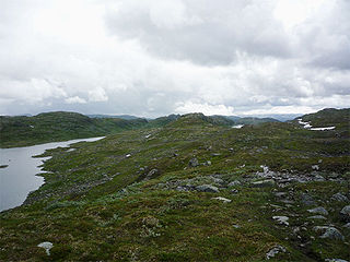
Setesdalsheiene is the collective term for the mountains to the west and east of the Setesdalen valley in Agder county in Southern Norway. The river Otra flows through the valley between the mountains. This area is primarily located in the municipalities of Bykle, Valle, Bygland, Evje og Hornnes, Sirdal, Kvinesdal, and Åseral. The vast Hardangervidda plateau lies to the north and the Ryfylkeheiene mountains lie to the west.
Lauvdal is a village in the municipality of Bygland in Agder county, Norway. It's located along the Norwegian National Road 9 on the east side of Byglandsfjorden. The village lies about 6 kilometres (3.7 mi) south of the village of Bygland and about the same distance north of the village of Longerak. The population (2001) was 41 residents. The lake Longerakvatnet is located about 6 kilometres (3.7 mi) southeast of the village.

Ose is a village in Bygland municipality in Agder county, Norway. The village is located along the river Otra, just north of the lake Åraksfjorden. The Norwegian National Road 9 runs through the village. Just across the river to the north lies the village of Austad, and about 1.5 kilometres (0.93 mi) to the north along Highway 9 lies the village of Moi.

Norwegian National Road 9 is often called the Setesdal Road and it is the main thoroughfare through the Setesdalen valley. It runs from the city of Kristiansand in the southern coast of Norway, through the Torridal and Setesdal valleys in Agder county to Haukeligrend in Vestfold og Telemark county in the north where it meets the European route E134 highway. The highway goes through the villages of Mosby, Homstean, Skarpengland, Hægeland, Hornesund, Hornnes, Evje, Byglandsfjord, Bygland, Ose, Rysstad, Valle, Flatland, Rygnestad, Bykle, Hovden, Bjåen, and Haukeli.

Byglandsfjord Station was a railway station in the village of Byglandsfjord in Bygland municipality in Agder county, Norway. It was the terminus station for the old Setesdal Line that traveled up the Setesdal valley from Kristiansand - Grovane - Byglandsfjord until the railway line was closed in 1962. The station sits on the eastern shore of the river Otra, at the south end of the lake Byglandsfjorden.


