Related Research Articles
Hydropower, also known as water power, is the use of falling or fast-running water to produce electricity or to power machines. This is achieved by converting the gravitational potential or kinetic energy of a water source to produce power. Hydropower is a method of sustainable energy production. Hydropower is now used principally for hydroelectric power generation, and is also applied as one half of an energy storage system known as pumped-storage hydroelectricity.

The South Platte River is one of the two principal tributaries of the Platte River. Flowing through the U.S. states of Colorado and Nebraska, it is itself a major river of the American Midwest and the American Southwest/Mountain West. Its drainage basin includes much of the eastern flank of the Rocky Mountains in Colorado, much of the populated region known as the Colorado Front Range and Eastern Plains, and a portion of southeastern Wyoming in the vicinity of the city of Cheyenne. It joins the North Platte River in western Nebraska to form the Platte, which then flows across Nebraska to the Missouri. The river serves as the principal source of water for eastern Colorado. In its valley along the foothills in Colorado, it has permitted agriculture in an area of the Colorado Piedmont and Great Plains that is otherwise arid.
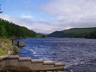
Derwent Reservoir is the middle of three reservoirs in the Upper Derwent Valley in the north of Derbyshire, England. It lies approximately 10 mi (16 km) from Glossop and 10 mi (16 km) from Sheffield. The River Derwent flows first through Howden Reservoir, then Derwent Reservoir and finally through Ladybower Reservoir. Between them they provide practically all of Derbyshire's water, as well as to a large part of South Yorkshire and as far afield as Nottingham and Leicester.

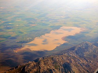
Hartbeespoort Dam is an arch type dam situated in the North West Province of South Africa. It lies in a valley to the south of the Magaliesberg mountain range and north of the Witwatersberg mountain range, about 35 kilometres north west of Johannesburg and 20 kilometres west of Pretoria. The name of the dam means "dam at the gorge of the hartebeest" in Afrikaans. This "poort" in the Magaliesberg was a popular spot for hunters, where they cornered and shot the hartebeest. The dam was originally designed for irrigation, which is currently its primary use, as well as for domestic and industrial use. The dam has suffered from a hypertrophic state since the early 1970s. Mismanagement of waste water treatment from urban zones within the Hartbeespoort Dam catchment area is largely to blame, having distorted the food web with over 280 tons of phosphate and nitrate deposits.
East Branch Reservoir, is a reservoir in the town of Southeast, New York, near the village of Brewster. Part of the New York City water supply system, it was formed by impounding the East Branch of the Croton River. Forming part of the Croton Watershed, it was placed into service in 1891, and lies some 35 miles (56 km) north of the city, in the southeast corner of Putnam County.

The Steenbras Dam, now referred to as Steenbras Lower Dam, is a gravity concrete arch type dam located in the Hottentots-Holland mountains, above Gordons Bay, near Cape Town in South Africa. It is one of the six large dams that make up the Western Cape Water Supply System. It is owned by the City of Cape Town and serves principally to supply water to that city. The dam wall is 28 metres (92 ft) high and 412 metres (1,352 ft) long; it impounds a reservoir of 36,133 megalitres over a surface area of 380 hectares when full.

South Holston Dam is a hydroelectric and flood control dam on the South Fork Holston River in Sullivan County, in the U.S. state of Tennessee. It is the uppermost of three dams on the South Fork Holston owned and operated by the Tennessee Valley Authority, which built the dam in the 1940s as part of efforts to control flooding in the Tennessee River watershed. On October 21, 1950 the valve gate closed and water began backing up to create South Holston Reservoir. Work began on the dam in December 1941, but in November 1942, the War Production Board requested that the operation be suspended because of a shortage of critical materials. Work did not resume until July 1, 1947. The dam now impounds the South Holston Lake of 7,550 acres (3,060 ha), which extends northeastward across the Tennessee-Virginia state line.
Heinrich Schörbeck was a seer, healer and magician who settled in South Africa around 1811.
Fish to Tsitsikama WMA, or Fish to Tsitsikama Water Management Area , in South Africa Includes the following major rivers: the Fish River, Kowie River, Boesmans River, Sundays River, Gamtoos River, Kromme River, Tsitsikamma River and Groot River, and covers the following Dams:
Olifants/Doorn WMA, or Olifants/Doorn Water Management Area, Includes the following major rivers: the Olifants River, Doorn River, Krom River, Sand River, and Sout River, and covers the following dams:
Boegoeberg Dam is a gravity type dam on the Orange River, near Prieska, Northern Cape, South Africa. Building was started in 1926 and completed by 1933. Boegoeberg is named for the small tree Croton gratissimus, also known as Bergboegoe. Its primary purpose is for irrigation and it has a low hazard potential.

Darlington Dam, also referred to as Lake Mentz. is a gravity type dam situated in the Sundays River, near Kirkwood, in Eastern Cape, South Africa. It was completed in 1922 and only filled by 1928, the delay a result of extensive drought.
Impofu Dam is a combined rock-fill/earth-fill type dam located on the Kromme River, near Humansdorp, Eastern Cape, South Africa. It was established in 1983 and its primary purpose is to serve for municipal and industrial use. The hazard potential of the dam construction has been ranked high (3).
Voëlvlei Dam is a dam located in the Western Cape, South Africa near the town of Gouda. The earth-fill wall is 2,910 metres (9,550 ft) long and 10 metres (33 ft) high. The reservoir covers an area of 1,524 hectares and has a capacity of 168,000 megalitres, making it the second-largest reservoir in the Western Cape Water Supply System. Water from the reservoir is supplied to water treatment works of the City of Cape Town and the West Coast District Municipality, and can also be released into the Berg River for agricultural purposes or to fill the Misverstand Dam.

Wemmershoek Dam is a rock-fill type dam located on the Wemmershoek River near Franschhoek and Paarl in South Africa. It was constructed between 1953 and 1957 on behalf of the City of Cape Town. With a reservoir capacity of 58,644 megalitres, it provides approximately 6.5% of the storage capacity of the Western Cape Water Supply System which supplies Cape Town and surrounding areas.

Woodhead Dam is a dam on Table Mountain, Western Cape, South Africa. It was built in 1897 and supplies water to Cape Town. The dam, which was the first large masonry dam in South Africa, was designated as an International Historic Civil Engineering Landmark by the American Society of Civil Engineers in 2008.

The Eerste River, located in the Western Cape, South Africa, rises on Dwarsberg 60 km east of Cape Town at the head of Jonkershoek valley. The Eerste River catchment covers the eastern part of the Cape Flats lying to the west of the Hottentots Holland Mountains and south of the Tygerberg where the Kuils River tributary rises east of Kanonkop. The Eerste River is a short river; its length has been given as 40 km. The major tributary, Kuils River, is approximately 30 km long to its point of confluence with the Eerste River.

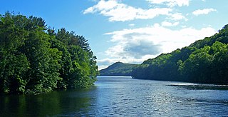
Saville Dam is an earthen embankment dam with masonry work on the eastern branch of the Farmington River in southwestern Barkhamsted, Connecticut and central Hartland, Connecticut, dividing the latter into two villages along its hilltops, East and West Hartland. The dam is 135 ft. tall and 1,950 ft. long and has an uncontrolled spillway on its western portion. It creates the Barkhamsted Reservoir which has a volume of 36.8 billion US gallons (139,000,000 m3) and is the primary water source for Hartford, Connecticut. Connecticut Route 318, also known as Saville Dam Road, crosses over the top of the dam.
The Vaal River Barrage Reservoir is a dam on the Vaal River near Vanderbijlpark, border Gauteng and Free State, South Africa.

Krom River or Kromme River is a river in the Eastern Cape Province in South Africa. The river flows into the Indian Ocean through an estuary on the north side of St Francis Bay, west of Port Elizabeth. The Krom river flows in an ESE direction and is approximately 109 km long with a catchment area of 1,085 km2.
References
| Authority control databases: Geographic |
|---|
This article about a dam or floodgate in South Africa is a stub. You can help Wikipedia by expanding it. |