The Neva is a river in northwestern Russia flowing from Lake Ladoga through the western part of Leningrad Oblast to the Neva Bay of the Gulf of Finland. Despite its modest length of 74 kilometres (46 mi), it is the fourth largest river in Europe in terms of average discharge.

The Petrovsky Stadium is on a sports complex that consists of a number of buildings, the stadium is used mostly for football and also for athletics. It was the home of FC Zenit and FC Tosno.

Bolshaya Neva is the largest armlet of Neva River. It starts near the Vasilievsky Island's Strelka . The Bolshaya Neva is 3.5 kilometres (2.2 mi) long; the width is from 200 to 400 metres and the depth up to 12.8 metres (42 ft). Its tributaries are Fontanka, Moyka and Novo-Admiralteysky Canal. There are two bridges across Bolshaya Neva: Palace Bridge and Blagoveshchensky Bridge.
Malaya Neva is the second largest distributary of the Neva River. The Neva splits into Bolshaya Neva and Malaya Neva near the Vasilievsky Island's Strelka, in the historic center of the city of Saint Petersburg.

Vvedensky Municipal Okrug, formerly Municipal Okrug #58, is a municipal okrug of Petrogradsky District of the federal city of St. Petersburg, Russia. Population: 19,778 (2010 Census); 21,374 (2002 Census).
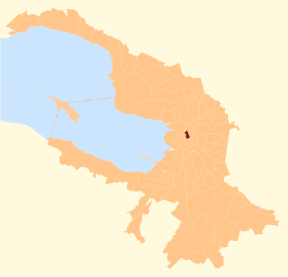
Kronverkskoye Municipal Okrug is a municipal okrug of Petrogradsky District of the federal city of St. Petersburg, Russia. Population: 20,513 (2010 Census); 21,256 (2002 Census).
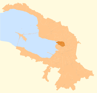
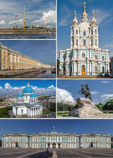
Petrogradsky District is a district of the federal city of St. Petersburg, Russia. It borders the Bolshaya Nevka River in the north and in the east, the Neva River in the south, and areas around the Malaya Neva River in the west. District's population: 130,455 (2010 Census); 134,607 (2002 Census).

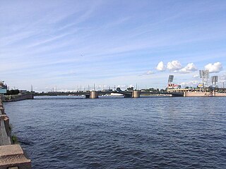
Exchange Bridge is the bridge across Malaya Neva in Saint Petersburg, Russia. Its length is 239 meters and width is 27 meters. Birzhevoy bridge connects Vasilievsky Island and Petrogradsky Island. It takes its name from the famous Old Saint Petersburg Stock Exchange building located on Vasilievsky Island.

Tuchkov Bridge is the bridge across Malaya Neva in Saint Petersburg, Russia. Its length is 226 meters and its width is 36 meters. Tuchkov bridge connects Vasilievsky Island and Petrogradsky Island.

The Blue Bridge, is a 97.3-metre-wide (319 ft) bridge that spans the Moika River in Saint Petersburg, Russia. The Blue Bridge is the widest bridge in Saint Petersburg and is sometimes claimed to be the widest bridge in the world – a claim, however, that has not been recognized by international reference works, such as the Guinness World Records.

Kazansky Bridge is a bridge across Griboyedov Canal in Saint Petersburg, Russia. From 1766 to 1830, it had the name Rozhdestvensky Bridge and from 1923 to 1944—Plekhanov Bridge. It is located near the Kazan Cathedral. The bridge's length is 18.8 metres (62 ft), and the width is 95.5 metres (313 ft). It is second-widest bridge in St. Petersburg after the Blue Bridge, the lowest bridge in the city and therefore also the only bridge where sailing underneath it is prohibited.

Kammennoostrovsky Prospekt is one of the main streets of Petrogradsky District of Saint Petersburg, spanning from Trinity Bridge and Trinity Square across Petrogradsky Island, the Karpovka River, Aptekarsky Island, the Malaya Nevka and Kamenny Island to the Bolshaya Nevka. It is served by the stations Gorkovskaya and Petrogradskaya of Saint Petersburg Metro. At Leo Tolstoy Square, where Petrogradskaya is situated, Kamennoostrovsky Prospekt crosses another large avenue, Bolshoy Prospekt. The section of Kamennoostrovsky Prospekt between Trinity Sq and the Malaya Nevka was named Red Dawns Street in 1918-1934 and Kirovsky Prospekt after Sergey Kirov in 1934-1991.

Aptekarsky Island is a small island situated in the northern part of the Neva delta. It is separated from Petrogradsky Island by the Karpovka River, from Kamenny Island and Krestovsky Island by the Malaya Nevka and from the Vyborgskaya region of St-Petersburg by the Bolshaya Nevka. It has an area of approximately two square kilometres. The name is thought to originate from the Finnish Korpisaari - "The island with the slumbering forest" or Korppisaari - "Crow's Island".

The Karpovka is a small river of the Neva basin in Saint Petersburg, Russia. It separates Aptekarsky Island from Petrogradsky Island. The Karpovka flows from the Bolshaya Nevka to the Malaya Nevka and is 3 kilometres (2 mi) long. The Russian name is derived from the old Finnish name of the river, Korpijoki. The Saint Petersburg Botanical Garden and Ioannovsky Convent are situated on the right bank of the river.

Bolshoy Prospekt of Petrograd Side is a large avenue in Petrogradsky District of Saint Petersburg, Russia, crossing Petrogradsky Island and spanning from Tuchkov Bridge across the Malaya Neva to Petropavlovsky Bridge across the Karpovka River. In 1918-1944 the avenue was named Karl Liebknecht Prospekt. The street is served by the stations Sportivnaya and Petrogradskaya of Saint Petersburg Metro. Not far from the Karpovka, at Leo Tolstoy Square, where Petrogradskaya is situated, Bolshoy Prospekt crosses another large avenue, Kamennoostrovsky Prospekt. While the rest of the road dates back to the 1730s, the short curved section of Bolshoy Prospekt between Kamennoostrovsky Prospekt and the Karpovka was constructed in 1910. After the Karpovka it turns into Prospekt Medikov. For most of its length, excluding the section between the Karpovka and Kamennoostrovsky Prospekt, Bolshoy Prospekt is a straight one-way street with south-west bound traffic heading towards Tuchkov Bridge. Bolshaya Pushkarskaya Street is used for traffic in the opposite direction.

The Military Historical Museum of Artillery, Engineers and Signal Corps, also known simply as the Artillery Museum, is a state-owned military museum in Saint Petersburg, Russia. Its collections, consisting of Russian military equipment, uniforms and decorations, are hosted in the Kronverk of the Peter and Paul Fortress situated on the right bank of the Neva near Alexander Park. The museum is managed by the Russian Ministry of Defence.

Zayachy Island is an island in the Neva River in St. Petersburg, Russia. It is separated by the Kronverksky Canal from Petrogradsky Island to the north, to which it is connected by the Kronverksky and Ioannovsky bridges.
The Zhdanovka River is a short river in the Neva River delta in Saint Petersburg, Russia. It separates Petrogradsky Island from Petrovsky Island.

The Baltic House Festival Theatre is a theatre at 4 Alexandrovsky Park, Saint Petersburg, on Petrogradsky Island. The theatre was started in 1936 as the Memorial Lenin Komsomol Theatre and was renamed Baltic House in 1991. The theater was renamed again in 2000 to its current name, Baltic House Festival Theatre. From 1936-1939 the theatre was located at 12 Vladimirsky Avenue, which is now the Memorial Leningrad Soviet Theatre. Baltic House moved to its current location in 1939.