Krychów

Last updated
Krychów
Village
Poland adm location map.svg
Red pog.svg
Krychów
Coordinates: 51°25′06″N23°21′31″E / 51.41833°N 23.35861°E / 51.41833; 23.35861
Country Flag of Poland.svg  Poland
Voivodeship Lublin
County Włodawa
Gmina Hańsk

Krychówpronounced  [ˈkrɨxuv] is a village neighbourhood (Polish : kolonia) in the administrative district of Gmina Hańsk, within Włodawa County, Lublin Voivodeship, in eastern Poland. In 1975–98 the settlement belonged administratively to Chełm Voivodeship. [1]

Village Small clustered human settlement smaller than a town

A village is a clustered human settlement or community, larger than a hamlet but smaller than a town, with a population ranging from a few hundred to a few thousand. Though villages are often located in rural areas, the term urban village is also applied to certain urban neighborhoods. Villages are normally permanent, with fixed dwellings; however, transient villages can occur. Further, the dwellings of a village are fairly close to one another, not scattered broadly over the landscape, as a dispersed settlement.

Polish language West Slavic language spoken in Poland

Polish is a West Slavic language of the Lechitic group. It is spoken primarily in Poland and serves as the native language of the Poles. In addition to being an official language of Poland, it is also used by Polish minorities in other countries. There are over 50 million Polish language speakers around the world and it is one of the official languages of the European Union.

Gmina Hańsk is a rural gmina in Włodawa County, Lublin Voivodeship, in eastern Poland. Its seat is the village of Hańsk, which lies approximately 20 kilometres (12 mi) south-west of Włodawa and 61 km (38 mi) east of the regional capital Lublin.

Contents

World War II

During occupation of Poland in World War II, Krychów was the location of a Nazi forced labour camp established in 1940 for the Polish Jews, with several sub-camps. [2]

Forced labour under German rule during World War II slavery and force labor under Nazi rule

The use of forced labour and slavery in Nazi Germany and throughout German-occupied Europe during World War II took place on an unprecedented scale. It was a vital part of the German economic exploitation of conquered territories. It also contributed to the mass extermination of populations in German-occupied Europe. The Nazi Germans abducted approximately 12 million people from almost twenty European countries; about two thirds came from Central Europe and Eastern Europe. Many workers died as a result of their living conditions – mistreatment, malnutrition, and torture were the main causes of death. They became civilian casualties of shelling. At its peak the forced labourers comprised 20% of the German work force. Counting deaths and turnover, about 15 million men and women were forced labourers at one point during the war.

Krychow forced labour camp, 1940. Polish Jewish prisoners build irrigation ditches for the new German latifundia of Generalplan Ost . Most were sent to Sobibor afterwards. Krychow forced labour camp 1940 (Krowie Bagno).jpg
Krychów forced labour camp, 1940. Polish Jewish prisoners build irrigation ditches for the new German latifundia of Generalplan Ost . Most were sent to Sobibór afterwards.

The camp in Krychów was set up by the Germans in place of a small correctional facility for short-term offenders founded in 1935 in interwar Poland, which was a branch of the Chełm prison. The prewar inmates were released by Polish administration already at the time of the invasion of Poland in the first days of September 1939 and the correctional centre stood empty. [2] The Germans set up a Jewish camp there for around 1,500 men and women who were forced to build farms for the German "colonists". [3] It was a main branch of several camps in Gmina Hańsk including Krychów, Hańsk-Dwór, [4] Osowa, and Ujazdów, for the innocuous captives expelled from the neighbouring settlements. [2]

Second Polish Republic 1918-1939 republic in Eastern Europe

The Second Polish Republic, commonly known as interwar Poland, refers to the country of Poland in the period between the First and Second World Wars (1918–1939). Officially known as the Republic of Poland, sometimes Commonwealth of Poland, the Polish state was re-established in 1918, in the aftermath of World War I. When, after several regional conflicts, the borders of the state were fixed in 1922, Poland's neighbours were Czechoslovakia, Germany, the Free City of Danzig, Lithuania, Latvia, Romania and the Soviet Union. It had access to the Baltic Sea via a short strip of coastline either side of the city of Gdynia. Between March and August 1939, Poland also shared a border with the then-Hungarian governorate of Subcarpathia. The Second Republic ceased to exist in 1939, when Poland was invaded by Nazi Germany, the Soviet Union and the Slovak Republic, marking the beginning of the European theatre of World War II.

Chełm Place in Lublin, Poland

Chełm is a city in eastern Poland with 63,949 inhabitants (2015). It is located to the south-east of Lublin, north of Zamość and south of Biała Podlaska, some 25 kilometres from the border with Ukraine. Chełm used to be the capital of the Chełm Voivodeship until it became part of the Lublin Voivodeship in 1999.

Invasion of Poland invasion of Poland by Germany, the Soviet Union, and a small Slovak contingent

The Invasion of Poland, known in Poland as the September Campaign or the 1939 Defensive War, and in Germany as the Poland Campaign (Polenfeldzug), was an invasion of Poland by Germany that marked the beginning of World War II. The German invasion began on 1 September 1939, one week after the signing of the Molotov–Ribbentrop Pact between Germany and the Soviet Union. The Soviets invaded Poland on 17 September following the Molotov–Tōgō agreement that terminated the Soviet and Japanese Battles of Khalkhin Gol in the east on 16 September. The campaign ended on 6 October with Germany and the Soviet Union dividing and annexing the whole of Poland under the terms of the German–Soviet Frontier Treaty.

The camp in Krychów was managed by the Nazi German administration of the General Plan East preparing latifundia for the colonists brought in Heim ins Reich (Home into the Empire) from among the foreign Volksdeutsche . Due to proximity of the Sobibór extermination camp many of the Jews who dug the irrigation ditches in these camps were simply marched under the German guard for extermination by gassing at Sobibór, [4] along with the imprisoned Romani people. [2]

<i>Heim ins Reich</i>

The Heim ins Reich was a foreign policy pursued by Adolf Hitler during World War II, beginning in 1938. The aim of Hitler's initiative was to convince all Volksdeutsche who were living outside Nazi Germany that they should strive to bring these regions "home" into Greater Germany, but also, relocate from territories that were not under German control, following the conquest of Poland in accordance with the Nazi-Soviet pact. The Heim ins Reich manifesto targeted areas ceded in Versailles to the newly reborn nation of Poland, as well as other areas that were inhabited by significant German populations such as the Sudetenland, Danzig, and the south-eastern and north-eastern regions of Europe after October 6, 1939.

Volksdeutsche

In Nazi German terminology, Volksdeutsche were "Germans in regard to people or race", regardless of citizenship. The term is the nominalised plural of volksdeutsch, with Volksdeutsche denoting a singular female, and Volksdeutsche(r), a singular male. The words Volk and völkisch conveyed the meanings of "folk". These terms were used by the Nazis to define Germans on the basis of their "race" rather than citizenship and thus included Germans living beyond the borders of the Reich, as long as they were not of Jewish origin.

Geography

Krychów is located at the heart of Pojezierze Łęczyńsko-Włodawskie characterized by profusion of marshlands and meadows. There is less arable land here than in other areas of the central-Polish lowland. It is a legally protected area, a part of the Sobibór Landscape Park criss-crossed with hiking and biking trails for tourists. [5]

Western Polesie Natural and historical region in Poland

Western Polesie - - a geological macro-region, being part of the north-western part of Polesie, to the west of the River Bug. In geological terms, the lowland is part of the pre-Cambrian region. The north of the pre-Cambrian has carboniferous deposits, as well as deposits of cenozoic and chalk.

Landscape park (protected area) type of protected area in some countries

A landscape park is a type of protected area in Czech Republic, Poland, Slovakia, Ukraine, Hungary and Slovenia. It is of lower status than a National Park and with less stringent restrictions on development and economic use.

Sobibór Landscape Park landscape park of Poland

Sobibór Landscape Park is a protected area created in Lublin Voivodeship, eastern Poland in 1983. It takes its name from the village of Sobibór.

Related Research Articles

Sobibor extermination camp German extermination camp located near Sobibór, Poland in World War II

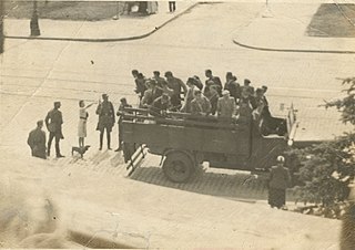
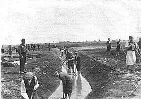
Sobibor was a Nazi German extermination camp built and operated by the SS during World War II near the railway station of Sobibór near Włodawa within the semi-colonial territory of General Government of the occupied Second Polish Republic.

Lublin Voivodeship Voivodeship in Poland

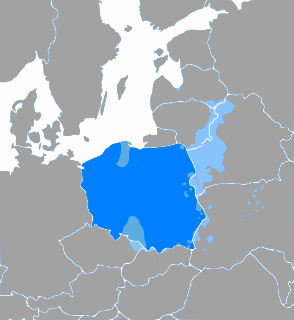
Lublin Voivodeship, or Lublin Province, is a voivodeship, or province, located in southeastern Poland. It was created on January 1, 1999, out of the former Lublin, Chełm, Zamość, Biała Podlaska and (partially) Tarnobrzeg and Siedlce Voivodeships, pursuant to Polish local government reforms adopted in 1998. The province is named after its largest city and regional capital, Lublin, and its territory is made of four historical lands: the western part of the voivodeship, with Lublin itself, belongs to Lesser Poland, the eastern part of Lublin Area belongs to Red Ruthenia, and the northeast belongs to Polesie and Podlasie.

Sobibór, Lublin Voivodeship Village in Lublin, Poland

Sobibór is a village in the administrative district of Gmina Włodawa, within Włodawa County, Lublin Voivodeship, in eastern Poland. It lies close to the Bug River, which forms the border with Belarus and Ukraine.

Końskowola Village in Lublin, Poland

Końskowolapronounced [kɔɲskɔˈvɔla] is a village in southeastern Poland, located between Puławy and Lublin, near Kurów on the Kurówka River. It is the seat of a separate commune (gmina) within Puławy County in Lublin Voivodeship, called Gmina Końskowola; population: 2,188 inhabitants.

Izbica Village in Lublin, Poland

Izbicapronounced ['izˈbit͡sa] is a village in the Krasnystaw County of the Lublin Voivodeship in eastern Poland. It is the seat of the gmina administrative district called Gmina Izbica. It lies approximately 13 kilometres (8 mi) south of Krasnystaw and 59 km (37 mi) south-east of the regional capital Lublin. It has a population of 1,933.

Trawniki Village in Lublin, Poland

Trawniki is a village in Świdnik County, Lublin Voivodeship, in eastern Poland. It is the seat of the gmina called Gmina Trawniki. It lies approximately 24 kilometres (15 mi) south-east of Świdnik and 33 km (21 mi) south-east of the regional capital Lublin.

Parczew partisans part of Jewish resistance movement against Nazi Germany

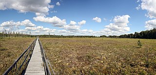
The Parczew partisans were fighters in irregular military groups participating in the Jewish resistance movement against Nazi Germany and its collaborators during World War II. The name of the partisan force, coined by the Holocaust historians, is borrowed from the Parczew forest located a short distance away from Lublin, halfway to the town of Sobibór, the location of the Sobibór extermination camp during the Holocaust in occupied Poland. The Jews who managed to escape from the camp hid in there along with the considerable number of Jewish families of the Lublin Ghetto.

Gmina Włodawa is a rural gmina in Włodawa County, Lublin Voivodeship, in eastern Poland, on the border with Belarus and Ukraine. Its seat is the town of Włodawa, although the town is not part of the territory of the gmina.

Świerże, Chełm County Village in Lublin, Poland

Świerże is a village in the administrative district of Gmina Dorohusk, within Chełm County, Lublin Voivodeship, in eastern Poland, close to the border with Ukraine. It lies approximately 9 kilometres (6 mi) north-west of Dorohusk, 19 km (12 mi) north-east of Chełm, and 82 km (51 mi) east of the regional capital Lublin.

Dubienka Village in Lublin, Poland

Dubienka is a village in Chełm County, Lublin Voivodeship, in eastern Poland, close to the border with Ukraine on the Bug River. It is the seat of the gmina called Gmina Dubienka. It lies approximately 31 kilometres (19 mi) east of Chełm and 95 km (59 mi) east of the regional capital Lublin.

Skryhiczyn Village in Lublin, Poland

Skryhiczyn is a village in the administrative district of Gmina Dubienka, within Chełm County, Lublin Voivodeship, in eastern Poland, close to the border with Ukraine. It lies approximately 9 kilometres (6 mi) south-east of Dubienka, 37 km (23 mi) south-east of Chełm, and 100 km (62 mi) east of the regional capital Lublin.

Siedliszcze, Gmina Siedliszcze Town in Lublin, Poland

Siedliszcze is a town in Chełm County, Lublin Voivodeship, in eastern Poland. It is the seat of the gmina called Gmina Siedliszcze. It lies approximately 23 kilometres (14 mi) west of Chełm and 42 km (26 mi) east of the regional capital Lublin.

Sawin, Lublin Voivodeship Settlement in Lublin, Poland

Sawin is a settlement in Chełm County, Lublin Voivodeship, in eastern Poland. It is the seat of the gmina called Gmina Sawin. It lies approximately 14 kilometres (9 mi) north of Chełm and 61 km (38 mi) east of the regional capital Lublin.

Dorohucza Village in Lublin, Poland

Dorohucza is a village in the administrative district of Gmina Trawniki, within Świdnik County, Lublin Voivodeship, in eastern Poland. It lies approximately 23 kilometres (14 mi) east of Świdnik and 33 km (21 mi) east of the regional capital Lublin. The village has a population of 753.

Hańsk-Kolonia is a village in the administrative district of Gmina Hańsk, within Włodawa County, Lublin Voivodeship, in eastern Poland.

Adampol, Lublin Voivodeship Village in Lublin, Poland

Adampol is a village in the administrative district of Gmina Wyryki, within Włodawa County, Lublin Voivodeship, in eastern Poland.

Grabowiec, Zamość County Village in Lublin, Poland

Grabowiec is a village in Zamość County, Lublin Voivodeship, in eastern Poland. It is the seat of the gmina called Gmina Grabowiec. It lies approximately 24 kilometres (15 mi) north-east of Zamość and 84 km (52 mi) south-east of the regional capital Lublin.

Kowale Pańskie Village in Greater Poland, Poland

Kowale Pańskie is a village in the administrative district of Gmina Kawęczyn, within Turek County, Greater Poland Voivodeship, in west-central Poland. It lies approximately 4 kilometres (2 mi) north of Kawęczyn, 10 km (6 mi) south of Turek, and 122 km (76 mi) south-east of the regional capital Poznań.

Sobibór Museum

The Sobibór Museum or the Museum of the Former Sobibór Nazi Death Camp, is a Polish state-owned museum devoted to remembering the atrocities committed at the former Sobibor extermination camp located on the outskirts of Sobibór near Lublin. The Nazi German death camp was set up in occupied Poland during World War II, as part of the Jewish extermination program known as the Operation Reinhard, which marked the most deadly phase of the Holocaust in Poland. The camp was run by the SS Sonderkommando Sobibor headed by Franz Stangl. The number of Jews from Poland and elsewhere who were gassed and cremated there between April 1942 and October 14, 1943 is estimated at 250,000; possibly more, including those who came from other Reich-occupied countries.

References

  1. "Central Statistical Office (GUS) - TERYT (National Register of Territorial Land Apportionment Journal)" (in Polish). 2008-06-01.
  2. 1 2 3 4 5 Sławomir Sobolewski. "Obozy pracy na terenie Gminy Hańsk" [World War II forced labour camps in Gmina Hańsk]. Hansk.info, the official webpage of Gmina Hańsk . Retrieved 29 September 2014.
  3. Aktion Reinhard Camps. Sobibor Labour Camps. 15 June 2006. ARC Website.
  4. 1 2 Grzegorz Welik (2012). "Parafia Św. Rajmunda. Rys Historyczny". Radiowa Niedziela. Radiopodlasie.pl. Retrieved 30 September 2014.
  5. "Sobibór Landscape Park. Tourism". Walory krajobrazowe. Szlaki turystyczne. Ścieżka rowerowa. Gmina Hańsk. 2015. Retrieved 2 June 2015.


Coordinates: 51°23′46″N23°22′43″E / 51.39611°N 23.37861°E / 51.39611; 23.37861

Geographic coordinate system Coordinate system

A geographic coordinate system is a coordinate system that enables every location on Earth to be specified by a set of numbers, letters or symbols. The coordinates are often chosen such that one of the numbers represents a vertical position and two or three of the numbers represent a horizontal position; alternatively, a geographic position may be expressed in a combined three-dimensional Cartesian vector. A common choice of coordinates is latitude, longitude and elevation. To specify a location on a plane requires a map projection.