
Biele is a village in the administrative district of Gmina Juchnowiec Kościelny, within Białystok County, Podlaskie Voivodeship, in north-eastern Poland. It lies approximately 5 kilometres (3 mi) south of Juchnowiec Kościelny and 15 km (9 mi) south of the regional capital Białystok.

Klewinowo is a village in the administrative district of Gmina Juchnowiec Kościelny, within Białystok County, Podlaskie Voivodeship, in north-eastern Poland. It lies approximately 6 kilometres (4 mi) south-east of Juchnowiec Kościelny and 15 km (9 mi) south of the regional capital Białystok.
Borowskie Skórki is a village in the administrative district of Gmina Turośń Kościelna, within Białystok County, Podlaskie Voivodeship, in north-eastern Poland. It lies approximately 6 kilometres (4 mi) south-west of Turośń Kościelna and 19 km (12 mi) south-west of the regional capital Białystok.
Aleksicze is a village in the administrative district of Gmina Zabłudów, within Białystok County, Podlaskie Voivodeship, in north-eastern Poland. It lies approximately 6 kilometres (4 mi) south of Zabłudów and 21 km (13 mi) south-east of the regional capital Białystok.
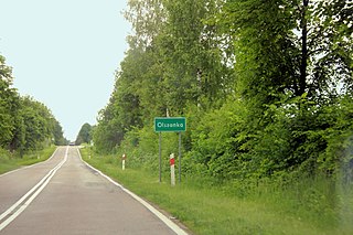
Ciełuszki is a village in the administrative district of Gmina Zabłudów, within Białystok County, Podlaskie Voivodeship, in north-eastern Poland. It lies approximately 14 kilometres (9 mi) south of Zabłudów and 28 km (17 mi) south-east of the regional capital Białystok.

Dawidowicze is a village in the administrative district of Gmina Zabłudów, within Białystok County, Podlaskie Voivodeship, in north-eastern Poland. It lies approximately 8 kilometres (5 mi) south of Zabłudów and 23 km (14 mi) southeast of the regional capital Białystok.
Gnieciuki is a village in the administrative district of Gmina Zabłudów, within Białystok County, Podlaskie Voivodeship, in north-eastern Poland. It lies approximately 3 kilometres (2 mi) south-east of Zabłudów and 19 km (12 mi) south-east of the regional capital Białystok.
Kaniuki is a village in the administrative district of Gmina Zabłudów, within Białystok County, Podlaskie Voivodeship, in north-eastern Poland. It lies approximately 14 kilometres (9 mi) south of Zabłudów and 26 km (16 mi) south of the regional capital Białystok.
Kołpaki is a village in the administrative district of Gmina Zabłudów, within Białystok County, Podlaskie Voivodeship, in north-eastern Poland. It lies approximately 9 kilometres (6 mi) south-east of Zabłudów and 25 km (16 mi) south-east of the regional capital Białystok.
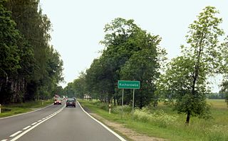
Kucharówka is a village in the administrative district of Gmina Zabłudów, within Białystok County, Podlaskie Voivodeship, in north-eastern Poland. It lies approximately 3 kilometres (2 mi) north-west of Zabłudów and 13 km (8 mi) south-east of the regional capital Białystok.
Laszki is a village in the administrative district of Gmina Zabłudów, within Białystok County, Podlaskie Voivodeship, in north-eastern Poland. It lies approximately 7 kilometres (4 mi) south-west of Zabłudów and 19 km (12 mi) south-east of the regional capital Białystok.
Małynka is a village in the administrative district of Gmina Zabłudów, within Białystok County, Podlaskie Voivodeship, in north-eastern Poland. It lies approximately 14 kilometres (9 mi) south-east of Zabłudów and 30 km (19 mi) south-east of the regional capital Białystok.
Miniewicze is a village in the administrative district of Gmina Zabłudów, within Białystok County, Podlaskie Voivodeship, in north-eastern Poland. It lies approximately 6 kilometres (4 mi) south of Zabłudów and 19 km (12 mi) south-east of the regional capital Białystok.
Olszanka is a village in the administrative district of Gmina Zabłudów, within Białystok County, Podlaskie Voivodeship, in north-eastern Poland. It lies approximately 6 kilometres (4 mi) south-east of Zabłudów and 22 km (14 mi) south-east of the regional capital Białystok.
Ostrówki is a village in the administrative district of Gmina Zabłudów, within Białystok County, Podlaskie Voivodeship, in north-eastern Poland. It lies approximately 6 kilometres (4 mi) south of Zabłudów and 21 km (13 mi) south-east of the regional capital Białystok.
Pawły is a village in the administrative district of Gmina Zabłudów, within Białystok County, Podlaskie Voivodeship, in north-eastern Poland. It lies approximately 10 kilometres (6 mi) south of Zabłudów and 23 km (14 mi) south-east of the regional capital Białystok.
Ryboły is a village in the administrative district of Gmina Zabłudów, within Białystok County, Podlaskie Voivodeship, in north-eastern Poland. It lies approximately 11 kilometres (7 mi) south-west of Zabłudów and 22 km (14 mi) south of the regional capital Białystok.
Rzepniki is a village in the administrative district of Gmina Zabłudów, within Białystok County, Podlaskie Voivodeship, in north-eastern Poland. It lies approximately 10 kilometres (6 mi) south-west of Zabłudów and 20 km (12 mi) south of the regional capital Białystok.
Sieśki is a village in the administrative district of Gmina Zabłudów, within Białystok County, Podlaskie Voivodeship, in north-eastern Poland. It lies approximately 6 kilometres (4 mi) south-east of Zabłudów and 21 km (13 mi) south-east of the regional capital Białystok.
Żywkowo is a village in the administrative district of Gmina Zabłudów, within Białystok County, Podlaskie Voivodeship, in north-eastern Poland. It lies approximately 8 kilometres (5 mi) south-east of Zabłudów and 24 km (15 mi) south-east of the regional capital Białystok.


