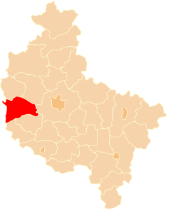
Boruja Kościelna is a village in the administrative district of Gmina Nowy Tomyśl, within Nowy Tomyśl County, Greater Poland Voivodeship, in west-central Poland. It lies approximately 6 kilometres (4 mi) south of Nowy Tomyśl and 56 km (35 mi) west of the regional capital Poznań.
Bukowiec is a village in the administrative district of Gmina Nowy Tomyśl, within Nowy Tomyśl County, Greater Poland Voivodeship, in west-central Poland. It lies approximately 9 kilometres (6 mi) east of Nowy Tomyśl and 48 km (30 mi) west of the regional capital Poznań.
Cicha Góra is a village in the administrative district of Gmina Nowy Tomyśl, within Nowy Tomyśl County, Greater Poland Voivodeship, in west-central Poland. It lies approximately 5 kilometres (3 mi) east of Nowy Tomyśl and 50 km (31 mi) west of the regional capital Poznań.
Glinno is a village in the administrative district of Gmina Nowy Tomyśl, within Nowy Tomyśl County, Greater Poland Voivodeship, in west-central Poland. It lies approximately 3 kilometres (2 mi) north-west of Nowy Tomyśl and 55 km (34 mi) west of the regional capital Poznań.
Jastrzębsko Stare is a village in the administrative district of Gmina Nowy Tomyśl, within Nowy Tomyśl County, Greater Poland Voivodeship, in west-central Poland. It lies approximately 5 kilometres (3 mi) west of Nowy Tomyśl and 59 km (37 mi) west of the regional capital Poznań.
Kozie Laski is a village in the administrative district of Gmina Nowy Tomyśl, within Nowy Tomyśl County, Greater Poland Voivodeship, in west-central Poland. It lies approximately 6 kilometres (4 mi) north-east of Nowy Tomyśl and 51 km (32 mi) west of the regional capital Poznań.
Paproć is a village in the administrative district of Gmina Nowy Tomyśl, within Nowy Tomyśl County, Greater Poland Voivodeship, in west-central Poland. It lies approximately 2 kilometres (1 mi) south of Nowy Tomyśl and 55 km (34 mi) west of the regional capital Poznań.
Róża is a village in the administrative district of Gmina Nowy Tomyśl, within Nowy Tomyśl County, Greater Poland Voivodeship, in west-central Poland. It lies approximately 9 kilometres (6 mi) north-east of Nowy Tomyśl and 47 km (29 mi) west of the regional capital Poznań.
Sątopy is a village in the administrative district of Gmina Nowy Tomyśl, within Nowy Tomyśl County, Greater Poland Voivodeship, in west-central Poland. It lies approximately 6 kilometres (4 mi) east of Nowy Tomyśl and 49 km (30 mi) west of the regional capital Poznań.
Kuślin is a village in Nowy Tomyśl County, Greater Poland Voivodeship, in west-central Poland. It is the seat of the gmina called Gmina Kuślin. It lies approximately 14 kilometres (9 mi) north-east of Nowy Tomyśl and 41 km (25 mi) west of the regional capital Poznań.
Michorzewo is a village in the administrative district of Gmina Kuślin, within Nowy Tomyśl County, Greater Poland Voivodeship, in west-central Poland. It lies approximately 4 kilometres (2 mi) east of Kuślin, 17 km (11 mi) east of Nowy Tomyśl, and 38 km (24 mi) west of the regional capital Poznań.
Śliwno is a village in the administrative district of Gmina Kuślin, within Nowy Tomyśl County, Greater Poland Voivodeship, in west-central Poland. It lies approximately 20 kilometres (12 mi) north-east of Nowy Tomyśl and 37 km (23 mi) west of the regional capital Poznań.
Toczeń is a village in the administrative district of Gmina Miedzichowo, within Nowy Tomyśl County, Greater Poland Voivodeship, in west-central Poland. It lies approximately 11 kilometres (7 mi) north-west of Nowy Tomyśl and 63 km (39 mi) west of the regional capital Poznań.
Drapak is a village in the administrative district of Gmina Opalenica, within Nowy Tomyśl County, Greater Poland Voivodeship, in west-central Poland. It lies approximately 4 kilometres (2 mi) south-east of Opalenica, 21 km (13 mi) east of Nowy Tomyśl, and 36 km (22 mi) west of the regional capital Poznań.
Łagwy is a village in the administrative district of Gmina Opalenica, within Nowy Tomyśl County, Greater Poland Voivodeship, in west-central Poland. It lies approximately 6 kilometres (4 mi) north-east of Opalenica, 22 km (14 mi) east of Nowy Tomyśl, and 33 km (21 mi) west of the regional capital Poznań.
Łęczyce is a village in the administrative district of Gmina Opalenica, within Nowy Tomyśl County, Greater Poland Voivodeship, in west-central Poland. It lies approximately 5 kilometres (3 mi) north-west of Opalenica, 16 km (10 mi) east of Nowy Tomyśl, and 39 km (24 mi) west of the regional capital Poznań.
Niegolewo is a village in the administrative district of Gmina Opalenica, within Nowy Tomyśl County, Greater Poland Voivodeship, in west-central Poland. It lies approximately 7 kilometres (4 mi) north of Opalenica, 23 km (14 mi) east of Nowy Tomyśl, and 32 km (20 mi) west of the regional capital Poznań.
Rudniki is a village in the administrative district of Gmina Opalenica, within Nowy Tomyśl County, Greater Poland Voivodeship, in west-central Poland. It lies approximately 5 kilometres (3 mi) north of Opalenica, 20 km (12 mi) east of Nowy Tomyśl, and 35 km (22 mi) west of the regional capital Poznań.
Terespotockie is a village in the administrative district of Gmina Opalenica, within Nowy Tomyśl County, Greater Poland Voivodeship, in west-central Poland. It lies approximately 5 kilometres (3 mi) south-west of Opalenica, 17 km (11 mi) east of Nowy Tomyśl, and 40 km (25 mi) west of the regional capital Poznań.
Troszczyn is a village in the administrative district of Gmina Opalenica, within Nowy Tomyśl County, Greater Poland Voivodeship, in west-central Poland. It lies approximately 4 kilometres (2 mi) south-east of Opalenica, 21 km (13 mi) east of Nowy Tomyśl, and 36 km (22 mi) west of the regional capital Poznań.