Krześlice

Last updated
Krześlice
Village

Krzeslice 3.jpg

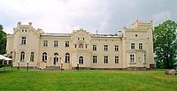
Neogothic palace in Krześlice, built in 1860.
Poland adm location map.svg
Red pog.svg
Krześlice
Coordinates: 52°31′N17°15′E / 52.517°N 17.250°E / 52.517; 17.250
Country Flag of Poland.svg Poland
Voivodeship Greater Poland
County Poznań County
Gmina Pobiedziska

Krześlice [kʂɛˈɕlit͡sɛ] (German : Dreilinden) is a village in the administrative district of Gmina Pobiedziska, within Poznań County, Greater Poland Voivodeship, in west-central Poland. [1] It lies approximately 3 kilometres (2 mi) north-west of Pobiedziska and 27 km (17 mi) north-east of the regional capital Poznań.

German language West Germanic language

German is a West Germanic language that is mainly spoken in Central Europe. It is the most widely spoken and official or co-official language in Germany, Austria, Switzerland, South Tyrol (Italy), the German-speaking Community of Belgium, and Liechtenstein. It is also one of the three official languages of Luxembourg and a co-official language in the Opole Voivodeship in Poland. The languages which are most similar to German are the other members of the West Germanic language branch: Afrikaans, Dutch, English, the Frisian languages, Low German/Low Saxon, Luxembourgish, and Yiddish. There are also strong similarities in vocabulary with Danish, Norwegian and Swedish, although those belong to the North Germanic group. German is the second most widely spoken Germanic language, after English.

Village Small clustered human settlement smaller than a town

A village is a clustered human settlement or community, larger than a hamlet but smaller than a town, with a population ranging from a few hundred to a few thousand. Though villages are often located in rural areas, the term urban village is also applied to certain urban neighborhoods. Villages are normally permanent, with fixed dwellings; however, transient villages can occur. Further, the dwellings of a village are fairly close to one another, not scattered broadly over the landscape, as a dispersed settlement.

Gmina Pobiedziska is an urban-rural gmina in Poznań County, Greater Poland Voivodeship, in west-central Poland. Its seat is the town of Pobiedziska, which lies approximately 27 kilometres (17 mi) north-east of the regional capital Poznań.

The name of the village was first documented in 1396 in reference to a certain "Piotr of Crzyślice". During the sixteenth century the village was the property of the Przecławski family. In 1623 the village was the site of a banquet in honor of the son of the Polish king, Władysław (later king of Poland as well). By the eighteenth century the village was in decline but saw a revival in the nineteenth, when the "gothic revival" palace of the Radoński family was built, in 1860 (on the basis of an earlier estate. [2] However, in 1888, the Prussian Settlement Commission (see Prussian Partition of Poland) dispossessed the owner of the palace, Zygmunt Radoński, and gave the palace to an ethnic German noble, Georg von Littiechau (Radoński was "compensated" with land in Congress Poland). After Poland regained its independence the palace was purchased by an industrialist from Łódź. During the German occupation of Poland, there was a nearby military airport. After World War II the palace was taken over by the communist authorities and fell to ruin, while the village itself became part of a state owned farm (PGR). After the fall of communism the palace was bought out by private investors and turned into a hotel and a restaurant. [3]

Władysław IV Vasa King of Poland

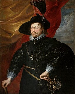
Władysław IV Vasa or Ladislaus IV Vasa was king of Poland of the House of Vasa who ruled from 1632 until his death in 1648. He was elected Tsar of Russia by the Seven Boyars in 1610, but did not assume the throne due to his father's position and a popular uprising.

Prussian Settlement Commission

The Prussian Settlement Commission was a Prussian government commission that operated between 1886 and 1924, but actively only until 1918. It was set up by Otto von Bismarck to increase land ownership by Germans at the expense of Poles, by economic and political means, in the German Empire's eastern provinces of West Prussia and the Posen as part of his larger efforts aiming at the eradication of the Polish nation. The Commission was motivated by anti-Polish sentiment and racism.

Congress Poland former state in Eastern Europe

Congress Poland or Russian Poland, formally known as the Kingdom of Poland, was a polity created in 1815 by the Congress of Vienna as a sovereign Polish state. Until the November Uprising in 1831, the kingdom was in a personal union with the Tsars of Russia. Thereafter, the state was forcibly integrated into the Russian Empire over the course of the 19th century. In 1915, during World War I, it was replaced by the Central Powers with the nominal Regency Kingdom of Poland, which continued to exist until Poland regained independence in 1918.

Related Research Articles

Kąty, Jarocin County Village in Greater Poland, Poland

Kąty is a village in the administrative district of Gmina Jarocin, within Jarocin County, Greater Poland Voivodeship, in west-central Poland. It lies approximately 6 kilometres (4 mi) north of Jarocin and 60 km (37 mi) south-east of the regional capital Poznań.

Konstantynów, Greater Poland Voivodeship Village in Greater Poland, Poland

Konstantynów is a village in the administrative district of Gmina Kramsk, within Konin County, Greater Poland Voivodeship, in west-central Poland. It lies approximately 7 kilometres (4 mi) east of Kramsk, 18 km (11 mi) east of Konin, and 111 km (69 mi) east of the regional capital Poznań.

Bednary, Greater Poland Voivodeship Village in Greater Poland, Poland

Bednary is a village in the administrative district of Gmina Pobiedziska, within Poznań County, Greater Poland Voivodeship, in west-central Poland. It lies approximately 6 kilometres (4 mi) north-west of Pobiedziska and 24 km (15 mi) north-east of the regional capital Poznań.

Borowo-Młyn Village in Greater Poland, Poland

Borowo-Młyn is a village in the administrative district of Gmina Pobiedziska, within Poznań County, Greater Poland Voivodeship, in west-central Poland. It lies approximately 5 kilometres (3 mi) south-west of Pobiedziska and 22 km (14 mi) north-east of the regional capital Poznań.

Jankowo, Poznań County Village in Greater Poland, Poland

Jankowo is a village in the administrative district of Gmina Pobiedziska, within Poznań County, Greater Poland Voivodeship, in west-central Poland. It lies approximately 9 kilometres (6 mi) south-west of Pobiedziska and 18 km (11 mi) east of the regional capital Poznań.

Jerzykowo, Poznań County Village in Greater Poland, Poland

Jerzykowo is a village in the administrative district of Gmina Pobiedziska, within Poznań County, Greater Poland Voivodeship, in west-central Poland. It lies approximately 6 kilometres (4 mi) west of Pobiedziska and 21 km (13 mi) north-east of the regional capital Poznań.

Jerzyn Village in Greater Poland, Poland

Jerzyn is a village in the administrative district of Gmina Pobiedziska, within Poznań County, Greater Poland Voivodeship, in west-central Poland. It lies approximately 3 kilometres (2 mi) west of Pobiedziska and 25 km (16 mi) north-east of the regional capital Poznań.

Kocanowo Village in Greater Poland, Poland

Kocanowo is a village in the administrative district of Gmina Pobiedziska, within Poznań County, Greater Poland Voivodeship, in west-central Poland. It lies approximately 5 kilometres (3 mi) east of Pobiedziska and 31 km (19 mi) east of the regional capital Poznań.

Kołata Village in Greater Poland, Poland

Kołata is a village in the administrative district of Gmina Pobiedziska, within Poznań County, Greater Poland Voivodeship, in west-central Poland. It lies approximately 6 kilometres (4 mi) west of Pobiedziska and 22 km (14 mi) north-east of the regional capital Poznań.

Podarzewo Village in Greater Poland, Poland

Podarzewo is a village in the administrative district of Gmina Pobiedziska, within Poznań County, Greater Poland Voivodeship, in west-central Poland. It lies approximately 5 kilometres (3 mi) north-east of Pobiedziska and 30 km (19 mi) north-east of the regional capital Poznań.

Polska Wieś, Poznań County Village in Greater Poland, Poland

Polska Wieś is a village in the administrative district of Gmina Pobiedziska, within Poznań County, Greater Poland Voivodeship, in west-central Poland. It lies approximately 3 kilometres (2 mi) south-east of Pobiedziska and 28 km (17 mi) east of the regional capital Poznań.

Pomarzanowice Village in Greater Poland, Poland

Pomarzanowice is a village in the administrative district of Gmina Pobiedziska, within Poznań County, Greater Poland Voivodeship, in west-central Poland. It lies approximately 2 kilometres (1 mi) north-east of Pobiedziska and 28 km (17 mi) north-east of the regional capital Poznań.

Stęszewko Village in Greater Poland, Poland

Stęszewko is a village in the administrative district of Gmina Pobiedziska, within Poznań County, Greater Poland Voivodeship, in west-central Poland. It lies approximately 9 kilometres (6 mi) north-west of Pobiedziska and 23 km (14 mi) north-east of the regional capital Poznań.

Węglewo, Poznań County Village in Greater Poland, Poland

Węglewo is a village in the administrative district of Gmina Pobiedziska, within Poznań County, Greater Poland Voivodeship, in west-central Poland. It lies approximately 3 kilometres (2 mi) east of Pobiedziska and 29 km (18 mi) north-east of the regional capital Poznań.

Wójtostwo, Greater Poland Voivodeship Village in Greater Poland, Poland

Wójtostwo is a village in the administrative district of Gmina Pobiedziska, within Poznań County, Greater Poland Voivodeship, in west-central Poland. It lies approximately 4 kilometres (2 mi) south of Pobiedziska and 26 km (16 mi) east of the regional capital Poznań.

Wronczyn, Gmina Pobiedziska Village in Greater Poland, Poland

Wronczyn is a village in the administrative district of Gmina Pobiedziska, within Poznań County, Greater Poland Voivodeship, in west-central Poland. It lies approximately 5 kilometres (3 mi) west of Pobiedziska and 23 km (14 mi) north-east of the regional capital Poznań.

Złotniczki, Greater Poland Voivodeship Village in Greater Poland, Poland

Złotniczki is a village in the administrative district of Gmina Pobiedziska, within Poznań County, Greater Poland Voivodeship, in west-central Poland. It lies approximately 2 kilometres (1 mi) north-west of Pobiedziska and 26 km (16 mi) north-east of the regional capital Poznań.

Glinienko Village in Greater Poland, Poland

Glinienko is a former village in the administrative district of Gmina Suchy Las, within Poznań County, Greater Poland Voivodeship, in west-central Poland. It lies approximately 6 kilometres (4 mi) north-east of Suchy Las and 13 km (8 mi) north of the regional capital Poznań.

Noskowo, Greater Poland Voivodeship Village in Greater Poland, Poland

Noskowo is a village in the administrative district of Gmina Września, within Września County, Greater Poland Voivodeship, in west-central Poland. It lies approximately 9 kilometres (6 mi) north-west of Września and 41 km (25 mi) east of the regional capital Poznań.

Skotniki, Greater Poland Voivodeship Village in Greater Poland, Poland

Skotniki is a village in the administrative district of Gmina Miłosław, within Września County, Greater Poland Voivodeship, in west-central Poland. It lies approximately 6 kilometres (4 mi) north-east of Miłosław, 11 km (7 mi) south-west of Września, and 45 km (28 mi) east of the regional capital Poznań.

References

Coordinates: 52°31′00″N17°15′00″E / 52.5167°N 17.2500°E / 52.5167; 17.2500

Geographic coordinate system Coordinate system

A geographic coordinate system is a coordinate system that enables every location on Earth to be specified by a set of numbers, letters or symbols. The coordinates are often chosen such that one of the numbers represents a vertical position and two or three of the numbers represent a horizontal position; alternatively, a geographic position may be expressed in a combined three-dimensional Cartesian vector. A common choice of coordinates is latitude, longitude and elevation. To specify a location on a plane requires a map projection.