
Bateaux Mouches are open excursion boats that provide visitors to Paris, France, with a view of the city from along the river Seine. They also operate on Parisian canals such as Canal Saint-Martin which is partially subterranean.

The University of Rzeszów is a university in Rzeszów, Poland. The patron of the university is Saint Queen Jadwiga of Poland.

The Roman Catholic Diocese of Rzeszów is a diocese located in the city of Rzeszów in the Ecclesiastical province of Przemyśl in Poland.

Glinki is a village in the administrative district of Gmina Radziłów, within Grajewo County, Podlaskie Voivodeship, in northeastern Poland.
Łączki-Pawłówek is a village in the administrative district of Gmina Borzechów, within Lublin County, Lublin Voivodeship, in eastern Poland.

Əzizbəyli is a village in the Qazakh Rayon of Azerbaijan.
Kraczewice Rządowe is a village in the administrative district of Gmina Poniatowa, within Opole Lubelskie County, Lublin Voivodeship, in eastern Poland.
Karsznice is a village in the administrative district of Gmina Małogoszcz, within Jędrzejów County, Świętokrzyskie Voivodeship, in south-central Poland. It lies approximately 6 kilometres (4 mi) south-east of Małogoszcz, 16 km (10 mi) north of Jędrzejów, and 26 km (16 mi) south-west of the regional capital Kielce.
Krasocin is a village in Włoszczowa County, Świętokrzyskie Voivodeship, in south-central Poland. It is the seat of the gmina called Gmina Krasocin. It lies approximately 12 kilometres (7 mi) east of Włoszczowa and 36 km (22 mi) west of the regional capital Kielce.
Kwisno is a village in Gmina Miastko, Bytów County, Pomeranian Voivodeship, in northern Poland. It lies approximately 25 kilometres (16 mi) south-west of Bytów and 103 km (64 mi) south-west of Gdańsk.
Rębienica is a village in the administrative district of Gmina Sierakowice, within Kartuzy County, Pomeranian Voivodeship, in northern Poland. It lies approximately 6 kilometres (4 mi) south-west of Sierakowice, 23 km (14 mi) west of Kartuzy, and 52 km (32 mi) west of the regional capital Gdańsk.
Szatarpy is a village in the administrative district of Gmina Nowa Karczma, within Kościerzyna County, Pomeranian Voivodeship, in northern Poland. It lies approximately 7 kilometres (4 mi) east of Nowa Karczma, 22 km (14 mi) east of Kościerzyna, and 33 km (21 mi) south-west of the regional capital Gdańsk.

Scenic Valley Ranchos is an unincorporated community in Calaveras County, California. It lies at an elevation of 384 feet.
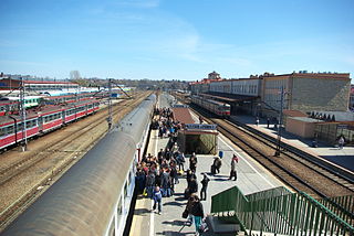
Rzeszów Główny is the most important station of the southeastern Polish city of Rzeszów, and the biggest of the Subcarpathian Voivodeship. According to the classification of passenger stations in Poland, it belongs to Class B.
Chrást is a village and municipality in Nymburk District in the Central Bohemian Region of the Czech Republic.
Viidu-Mäebe is a village in Saaremaa Parish, Saare County in western Estonia.

Podgaj is a village in the municipality of Srebrenica, Bosnia and Herzegovina.

Seydol Crag is the narrow, rocky ridge extending 2.9 km and rising to 800 m in the southeast foothills of Detroit Plateau on southern Trinity Peninsula in Graham Land, Antarctica. It is surmounting the upper course of Sjögren Glacier to the west and south.

Podpromie Hall is an indoor arena in Rzeszów, Poland.

Hoynat Islet is a Turkish islet in the Black Sea.


