Józefowo is a village in the administrative district of Gmina Izbica Kujawska, within Włocławek County, Kuyavian-Pomeranian Voivodeship, in north-central Poland. It lies approximately 3 kilometres (2 mi) east of Izbica Kujawska, 31 km (19 mi) south-west of Włocławek, and 69 km (43 mi) south of Toruń.
Długie is a village in the administrative district of Gmina Koluszki, within Łódź East County, Łódź Voivodeship, in central Poland. It lies approximately 5 kilometres (3 mi) east of Koluszki and 28 km (17 mi) east of the regional capital Łódź.
Felicjanów is a village in the administrative district of Gmina Koluszki, within Łódź East County, Łódź Voivodeship, in central Poland. It lies approximately 3 kilometres (2 mi) north-east of Koluszki and 26 km (16 mi) east of the regional capital Łódź.
Jeziorko is a village in the administrative district of Gmina Koluszki, within Łódź East County, Łódź Voivodeship, in central Poland. It lies approximately 4 kilometres (2 mi) north-east of Koluszki and 27 km (17 mi) east of the regional capital Łódź.
Kaletnik is a village in the administrative district of Gmina Koluszki, within Łódź East County, Łódź Voivodeship, in central Poland. It lies approximately 4 kilometres (2 mi) south of Koluszki and 24 km (15 mi) east of the regional capital Łódź.
Katarzynów is a village in the administrative district of Gmina Koluszki, within Łódź East County, Łódź Voivodeship, in central Poland. It lies approximately 4 kilometres (2 mi) east of Koluszki and 27 km (17 mi) east of the regional capital Łódź.
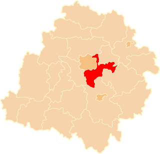
Kazimierzów is a village in the administrative district of Gmina Koluszki, within Łódź East County, Łódź Voivodeship, in central Poland. It lies approximately 7 kilometres (4 mi) east of Koluszki and 31 km (19 mi) east of the regional capital Łódź.
Słotwiny is a village in the administrative district of Gmina Koluszki, within Łódź East County, Łódź Voivodeship, in central Poland. It lies approximately 4 kilometres (2 mi) south-east of Koluszki and 27 km (17 mi) east of the regional capital Łódź.
Turobowice is a village in the administrative district of Gmina Koluszki, within Łódź East County, Łódź Voivodeship, in central Poland. It lies approximately 6 kilometres (4 mi) east of Koluszki and 30 km (19 mi) east of the regional capital Łódź.
Żakowice is a village in the administrative district of Gmina Koluszki, within Łódź East County, Łódź Voivodeship, in central Poland. It lies approximately 3 kilometres (2 mi) south-east of Koluszki and 25 km (16 mi) east of the regional capital Łódź.
Lipiny is a village in the administrative district of Gmina Nowosolna, within Łódź East County, Łódź Voivodeship, in central Poland. It lies approximately 15 kilometres (9 mi) east of the regional capital Łódź.
Dylew is a village in the administrative district of Gmina Tuszyn, within Łódź East County, Łódź Voivodeship, in central Poland. It lies approximately 5 kilometres (3 mi) south-west of Tuszyn and 23 km (14 mi) south of the regional capital Łódź.
Głuchów is a village in the administrative district of Gmina Tuszyn, within Łódź East County, Łódź Voivodeship, in central Poland. It lies approximately 7 kilometres (4 mi) south-east of Tuszyn and 26 km (16 mi) south of the regional capital Łódź.
Mąkoszyn is a village in the administrative district of Gmina Tuszyn, within Łódź East County, Łódź Voivodeship, in central Poland. It lies approximately 11 kilometres (7 mi) south of Tuszyn and 31 km (19 mi) south of the regional capital Łódź.
Orzeszków-Kolonia is a village in the administrative district of Gmina Uniejów, within Poddębice County, Łódź Voivodeship, in central Poland. It lies approximately 4 kilometres (2 mi) north of Uniejów, 17 km (11 mi) north-west of Poddębice, and 53 km (33 mi) north-west of the regional capital Łódź.
Jatno is a village in the administrative district of Gmina Żytno, within Radomsko County, Łódź Voivodeship, in central Poland.
Helenów is a village in the administrative district of Gmina Zwoleń, within Zwoleń County, Masovian Voivodeship, in east-central Poland. It lies approximately 7 kilometres (4 mi) east of Zwoleń and 105 km (65 mi) south-east of Warsaw.
Rogal is a village in the administrative district of Gmina Koźminek, within Kalisz County, Greater Poland Voivodeship, in west-central Poland. It lies approximately 15 kilometres (9 mi) east of Kalisz and 115 km (71 mi) south-east of the regional capital Poznań.
Żakowice is a village in the administrative district of Gmina Susz, within Iława County, Warmian-Masurian Voivodeship, in northern Poland. It lies approximately 9 kilometres (6 mi) south-west of Susz, 24 km (15 mi) west of Iława, and 85 km (53 mi) west of the regional capital Olsztyn.
Gołębiewo is a settlement in the administrative district of Gmina Szczecinek, within Szczecinek County, West Pomeranian Voivodeship, in north-western Poland.