Kuban-Black Sea Oblast

Last updated

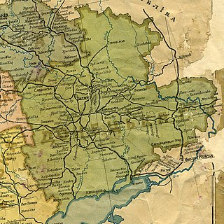
Kuban Black Sea Oblast (Russian : Куба́но-Черномо́рская о́бласть) was an administrative division (an oblast ) of the Russian Soviet Federative Socialist Republic which existed in 1920–1924.

Russian language East Slavic language

Russian is an East Slavic language, which is official in the Russian Federation, Belarus, Kazakhstan and Kyrgyzstan, as well as being widely used throughout Eastern Europe, the Baltic states, the Caucasus and Central Asia. It was the de facto language of the Soviet Union until its dissolution on 25 December 1991. Although nearly three decades have passed since the breakup of the Soviet Union, Russian is used in official capacity or in public life in all the post-Soviet nation-states, as well as in Israel and Mongolia.

An oblast is a type of administrative division of Belarus, Bulgaria, Kazakhstan, Kyrgyzstan, Russia, Ukraine, and the former Soviet Union and Kingdom of Yugoslavia.

Russian Soviet Federative Socialist Republic Republic in the USSR (1922–1991) and sovereign state (1917–1922 and 1990–1991)

The Russian Soviet Federative Socialist Republic, previously known as the Russian Soviet Republic and the Russian Socialist Federative Soviet Republic, as well as being unofficially known as the Russian Federation, Soviet Russia, or simply Russia, was an independent state from 1917 to 1922, and afterwards the largest, most populous and most economically developed of the 15 Soviet socialist republics of the Soviet Union (USSR) from 1922 to 1990, then a sovereign part of the Soviet Union with priority of Russian laws over Union-level legislation in 1990 and 1991, during the last two years of the existence of the USSR. The Russian Republic comprised sixteen smaller constituent units of autonomous republics, five autonomous oblasts, ten autonomous okrugs, six krais and forty oblasts. Russians formed the largest ethnic group. The capital of the Russian SFSR was Moscow and the other major urban centers included Leningrad, Novosibirsk, Yekaterinburg, Nizhny Novgorod and Samara.

When Soviet power was re-established in the region of Kuban in March 1920, the executive power in the region formally belonged to the Provisional Kuban Executive Committee, established on March 18, 1920. On March 27, 1920, the committee's duties were transferred to the Kuban Oblast Revolutionary Committee, which supervised the territories of Kuban Oblast and Black Sea Governorate. On March 29, 1920, the committee was renamed "Kuban Black Sea Revolutionary Committee", and as a result of that the joint territory of Kuban Oblast and Black Sea Governorate started to be referred to as "Kuban Black Sea Oblast", after the committee's new name, although no formal decrees establishing a new administrative unit had been passed. The new oblast was not officially recognized until December 7, 1920. [1]

Soviets were political organizations and governmental bodies, primarily associated with the Russian Revolutions and the history of the Soviet Union, and which gave the name to the latter state.

Kuban geographic region of Southern Russia

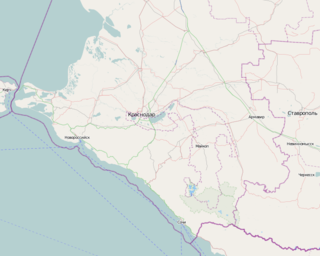
Kuban is a geographic region of Southern Russia surrounding the Kuban River, on the Black Sea between the Don Steppe, the Volga Delta and the Caucasus, and separated from the Crimean Peninsula to the west by the Kerch Strait. Krasnodar Krai is often referred to as "Kuban", both officially and unofficially, although the term is not exclusive to the krai and accommodates the republics of Adygea, Karachay-Cherkessia, and parts of Stavropol Krai.

Kuban Oblast Place in Oblast, Russia

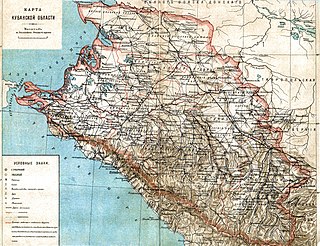
The Kuban Oblast was an oblast (province) of the Caucasus Viceroyalty of the Russian Empire. It roughly corresponded to most of the Kuban and Circassia regions. It was created in 1860 out of Kuban Cossack territories that had once been part of the Crimean Khanate and the land of the Circassians. It was dissolved upon the assumption of supreme authority by the Kuban Rada in 1917 and the independence of the Kuban People's Republic in 1918.

On August 7, 1920, the jurisdiction over Kuban Black Sea Oblast, as well as over several neighboring territories, was transferred to the Revolutionary Soviet of the South-East Russian Labor Army. Although the Soviet itself ceased to exist in the 1921, the territory of its jurisdiction continued to be informally known as "South-East" (sometimes also as "South-Eastern Krai" or "South-Eastern Oblast").

South-East, Russian SFSR

The South-East, also referred to as South-Eastern Krai and South-Eastern Oblast was a territory, and later an administrative division, of the Russian Soviet Federative Socialist Republic (RSFSR) which existed in 1920-1924.

Kuban Black Sea Oblast ceased to exist on February 13, 1924, when it was re-organized into four okrugs of South-Eastern Oblast (Krai).

Okrug is an administrative division of some Slavic states. The word "okrug" is a loanword in English, but it is nevertheless often translated as "area", "district", or "region".

Related Research Articles

Krasnodar Krai First-level administrative division of Russia

Krasnodar Krai is a federal subject of Russia, located in the North Caucasus region in Southern Russia and administratively a part of the Southern Federal District. Its administrative center is the city of Krasnodar. The third most-populous federal subject, the krai had a population of 5,226,647 as of the 2010 Census.

Monchegorsk Town in Murmansk Oblast, Russia

Monchegorsk is a town in Murmansk Oblast, Russia, located on the Kola Peninsula, 145 kilometers (90 mi) south of Murmansk, the administrative center of the oblast. Population: 45,361 (2010 Census); 52,242 ; 68,652.

Murmansk Oblast is a federal subject of Russia, which is located in the northwestern part of the country, occupying mostly the Kola Peninsula. The oblast itself was established on May 28, 1938, but some kind of administrative organization of the territory existed here since at least the 13th century. As of the 2002 Census, Russians account for the majority of the oblast's population, with the indigenous Sami constituting only a 0.20% minority (1,769 people).

Administratively, Novgorod Oblast is divided into three cities and towns of oblast significance and twenty-one districts.

Kirovsk, Murmansk Oblast Town in Murmansk Oblast, Russia

Kirovsk, known as Khibinogorsk (Хибиного́рск) until 1934, is a town in Murmansk Oblast, Russia, located at the spurs of the Khibiny Mountains on the shores of the Lake Bolshoy Vudyavr, 175 kilometers (109 mi) south of Murmansk. Population: 28,625 (2010 Census).

Nevel (town) Town in Pskov Oblast, Russia

Nevel is a town and the administrative center of Nevelsky District in Pskov Oblast, Russia, located on Lake Nevel 242 kilometers (150 mi) southeast of Pskov, the administrative center of the oblast. Population: 16,324 (2010 Census); 18,545 (2002 Census); 22,472 (1989 Census).

Administratively, Vologda Oblast is divided into four cities and towns of oblast significance and twenty-six districts.

Within the framework of administrative divisions, Arkhangelsk Oblast is divided into six cities and towns of oblast significance, twenty-one districts, and two island territories. Besides, Mirny is a town under the federal government management.

Black Sea Governorate Place in Governorate, Russia

The Black Sea Governorate, was one of the guberniyas of the Caucasus Viceroyalty of the Russian Empire.

Yeniseysk Governorate

Yeniseysk Governorate was a governorate (guberniya) of the Russian Empire and later of the Russian Socialist Federative Soviet Republic.

Kolsky District District in Murmansk Oblast, Russia

Kolsky District is an administrative district (raion), one of the six in Murmansk Oblast, Russia. As a municipal division, it is incorporated as Kolsky Municipal District. It is located in the northwest of the oblast, partially lies on the Kola Peninsula, and borders with the Barents Sea in the north and Finland in the west. The area of the district is 27,600 square kilometers (10,700 sq mi). Its administrative center is the town of Kola. Population: 44,670 (2010 Census); 51,125 (2002 Census); 73,555 (1989 Census). The population of Kola accounts for 23.4% of the district's total population.

Murmansk Krai was an informal name used in the early Russian SFSR to refer to the territory roughly corresponding to modern Murmansk Oblast. At various times, the term referred to the territory which included Alexandrovsky and Kemsky Uyezds of Arkhangelsk Governorate and some parts of Olonets Governorate.

Onezhsky District District in Arkhangelsk Oblast, Russia

Onezhsky District is an administrative district (raion), one of the twenty-one in Arkhangelsk Oblast, Russia. As a municipal division, it is incorporated as Onezhsky Municipal District. It is located in the northwest of the oblast and borders with Primorsky District in the northeast, Plesetsky District in the southeast, Pudozhsky, Medvezhyegorsky, and Segezhsky Districts of the Republic of Karelia in the southwest, and with Belomorsky District of the Republic of Karelia in the west. In the north, the district is washed by the White Sea. The area of the district is 23,740 square kilometers (9,170 sq mi). Its administrative center is the town of Onega. Population: 14,017 (2010 Census); 16,791 (2002 Census); 22,269 (1989 Census).

Kandalakshsky District District in Murmansk Oblast, Russia

Kandalakshsky District is an administrative district, one of the six in Murmansk Oblast, Russia. As a municipal division, it is incorporated as Kandalakshsky Municipal District. It is located in the southwest of the oblast, and borders with Kovdorsky District to the north, Loukhsky District of the Republic of Karelia, and with Finland to the west. The area of the district is 14,400 square kilometers (5,600 sq mi). Its administrative center is the town of Kandalaksha. Population: 49,544 (2010 Census); 60,140 (2002 Census); 78,239 (1989 Census). The population of Kandalaksha accounts for 72.0% of the district's total population.

Donets Governorate

Donets Governorate was a governorate of the Ukrainian SSR (Ukraine) that existed between 1919 and 1925.

Khostinsky City District District in Krasnodar Krai, Russia

Khostinsky City District is one of four city districts of the city of Sochi in Krasnodar Krai, Russia. The city district borders Maykopsky District of the Republic of Adygea in the northeast, Adlersky City District in the southeast, Tsentralny City District in the west, and Lazarevsky City District in the northwest. In the southwest, it is bordered by the Black Sea. Population: 65,229 (2010 Census); 62,515 (2002 Census); 65,713 (1989 Census).

Lazarevsky City District is one of four city districts of the city of Sochi in Krasnodar Krai, Russia. The city district borders Tuapsinsky District in the northwest, Apsheronsky District in the north, Maykopsky District of the Republic of Adygea in the northeast, Khostinsky City District in the east, and Tsentralny City District in the south. The administration of the district is located in Lazarevskoye Microdistrict. In the southwest, it is bordered by the Black Sea. Population: 63,894 (2010 Census); 63,239 (2002 Census); 64,006 (1989 Census).

References

  1. Сергей Тархов, "Изменение административно-территориального деления России в XIII-XX в." (pdf), Логос, #1 2005 (46), сс. 65-101, ISSN   0869-5377