Kubena River

Last updated

Coordinates: 59°35′20″N39°37′20″E / 59.58889°N 39.62222°E / 59.58889; 39.62222

Geographic coordinate system Coordinate system

A geographic coordinate system is a coordinate system that enables every location on Earth to be specified by a set of numbers, letters or symbols. The coordinates are often chosen such that one of the numbers represents a vertical position and two or three of the numbers represent a horizontal position; alternatively, a geographic position may be expressed in a combined three-dimensional Cartesian vector. A common choice of coordinates is latitude, longitude and elevation. To specify a location on a plane requires a map projection.

Kubena
Kubena River.JPG
Native name Russian: Кубена
Country Russia
Physical characteristics
Main source Konosha heights
River mouth Lake Kubenskoye
110 m (360 ft)
Length 368 km (229 mi) [1]
Discharge
  • Average rate:
    52.2 m3/s (1,840 cu ft/s) [1]
Basin features
Basin size 11,000 km2 (4,200 sq mi) [1]
Map of the Northern Dvina basin. The Kubena is shown on the map. Severnaya Dvina eng.svg
Map of the Northern Dvina basin. The Kubena is shown on the map.

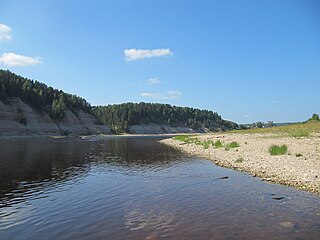
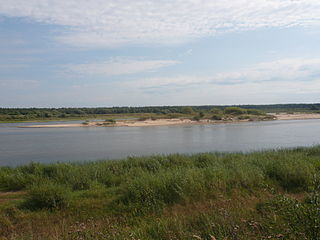
The Kubena (Russian : Кубена) is a river in Konoshsky District of Arkhangelsk Oblast and Vozhegodsky, Syamzhensky, Kharovsky, Sokolsky, and Ust-Kubinsky Districts of Vologda Oblast in Russia. It is 368 kilometres (229 mi) long, and the area of its basin 11,000 square kilometres (4,200 sq mi). The Kubena is the principal tributary of Lake Kubenskoye and belongs to the basins of the Sukhona River and the White Sea. Its main tributaries are the Syamzhena River (left) and the Sit River (right).

Russian language East Slavic language

Russian is an East Slavic language, which is official in the Russian Federation, Belarus, Kazakhstan and Kyrgyzstan, as well as being widely used throughout Eastern Europe, the Baltic states, the Caucasus and Central Asia. It was the de facto language of the Soviet Union until its dissolution on 25 December 1991. Although nearly three decades have passed since the breakup of the Soviet Union, Russian is used in official capacity or in public life in all the post-Soviet nation-states, as well as in Israel and Mongolia.

Konoshsky District District in Arkhangelsk Oblast, Russia

Konoshsky District is an administrative district (raion), one of the twenty-one in Arkhangelsk Oblast, Russia. As a municipal division, it is incorporated as Konoshsky Municipal District. It is located in the southwest of the oblast and borders with Nyandomsky District in the north, Velsky District in the east, Verkhovazhsky, Vozhegodsky, and Kirillovsky Districts of Vologda Oblast in the south, and with Kargopolsky District in the west. The area of the district is 8,500 square kilometers (3,300 sq mi). Its administrative center is the urban locality of Konosha. Population: 26,106 (2010 Census); 31,067 (2002 Census); 42,136 (1989 Census). The population of Konosha accounts for 47.6% of the district's total population.

Arkhangelsk Oblast First-level administrative division of Russia

Arkhangelsk Oblast is a federal subject of Russia. It includes the Arctic archipelagos of Franz Josef Land and Novaya Zemlya, as well as the Solovetsky Islands in the White Sea. Arkhangelsk Oblast also has administrative jurisdiction over Nenets Autonomous Okrug. Including Nenetsia, Arkhangelsk Oblast has an area of 587,400 km2. Its population was 1,227,626 as of the 2010 Census.

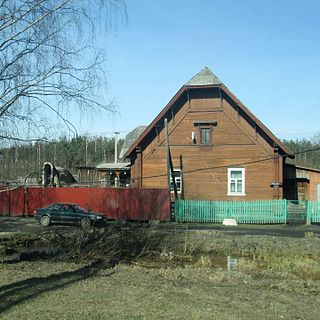
The town of Kharovsk is situated on the left bank of the river. The selo of Ustye, Ust-Kubinsky District, Vologda Oblast, and administrative center of Ust-Kubinsky District, is located in the mouth of the Kubena.

Kharovsk Town in Vologda Oblast, Russia

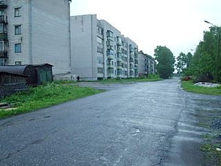
Kharovsk is a town and the administrative center of Kharovsky District in Vologda Oblast, Russia, located on the left bank of the Kubena River, 90 kilometers (56 mi) north of Vologda, the administrative center of the oblast. Population: 10,079 (2010 Census); 11,460 (2002 Census); 13,083 (1989 Census).

Ustye, Ust-Kubinsky District, Vologda Oblast Selo in Vologda Oblast, Russia

Ustye, also known as Ustye-Kubenskoye (Устье-Кубенское), is a rural locality and the administrative center of Ust-Kubinsky District of Vologda Oblast, Russia, located on the banks of the Kubena River close to its confluence with Lake Kubenskoye. It also serves as the administrative center of Ustyansky Selsoviet, one of the ten selsoviets into which the district is administratively divided. Municipally, it is the administrative center of Ustyanskoye Rural Settlement. Until 2004, Ustye had urban-type settlement status. Population: 3,938 (2010 Census); 4,148 (2002 Census); 4,534 (1989 Census).

The river basin of the Kubena comprises vast areas in the canter of Vologda Oblast and in the south of Arkhangelsk oblast and separates the river basing of the Onega River in the west and the Vaga River in the east. Four district centers of Vologda Oblast, Syamzha, Kharovsk, and Ustye, are located in the basin of the Kubena.

Onega River river in Russia

The Onega is a river in Kargopolsky, Plesetsky, and Onezhsky Districts of Arkhangelsk Oblast in Russia. The Onega connects Lake Lacha with the Onega Bay in the White Sea southwest of Arkhangelsk, flowing in the northern direction. The discharge at the source is 74.1 cubic metres per second (2,620 cu ft/s) and at the mouth is 505 cubic metres per second (17,800 cu ft/s). The river is 416 kilometres (258 mi) long, and the area of its basin 56,900 square kilometres (22,000 sq mi). Its main tributaries are the Voloshka (right), the Kena (left), the Mosha (right), the Kodina (right), and the Kozha (left). The major tributary of the Lake Lacha is the Svid.

Vaga River Russian river

The Vaga is a river in Totemsky, Syamzhensky, and Verkhovazhsky Districts of Vologda Oblast and in Velsky, Shenkursky, and Vinogradovsky Districts of Arkhangelsk Oblast in Russia. It is a left and the biggest tributary of the Northern Dvina River. The length of the river is 575 kilometres (357 mi). The area of its basin 44,800 square kilometres (17,300 sq mi). The main tributaries of the Vaga River are the Pezhma (left), the Vel (left), the Kuloy (right), the Ustya (right), the Puya (left), and the Led (left).

Syamzha Selo in Vologda Oblast, Russia

Syamzha is a rural locality and the administrative center of Syamzhensky District of Vologda Oblast, Russia, located on both banks of the Syamzhena River, a tributary of the Kubena River. It also serves as the administrative center of Syamzhensky Selsoviet, one of the ten selsoviets into which the district is administratively divided. Municipally, it is the administrative center of Syamzhenskoye Rural Settlement. Population: 3,950 (2010 Census); 3,932 (2002 Census); 3,928 (1989 Census).

The source of the Kubena is located in the hills south of the settlement of Konosha. The river flows south, enters Vologda Oblast, turns northeast and crosses Vozhegodsky District, turning south, and eventually southwest. It accepts the Syamzhena from the left and turns west. Downstream of the town of Kharovsk the Kubena accepts the Sit from the right and eventually turns southwest. Exiting Kharovsky District, a stretch of the Kubena forms the border between Ust-Kubinsky District (right) and Sokolsky District (left). Further the Kubena enters Ust-Kubinsky district and empties into Lake Kubenskoye, forming a river delta.

Konosha Urban-type settlement in Arkhangelsk Oblast, Russia

Konosha is an urban locality and the administrative center of Konoshsky District, Arkhangelsk Oblast, Russia, located on the Konosha River, 400 kilometers (250 mi) south of Arkhangelsk. It also serves as the administrative center of Danilovsky Selsoviet, one of the ten selsoviets into which the district is administratively divided. Municipally, it is incorporated as Konoshskoye Urban Settlement. Population: 12,432 (2010 Census); 12,873 (2002 Census); 17,143 (1989 Census).

River delta Silt deposition landform at the mouth of a river

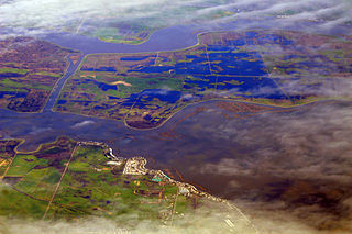
A river delta is a landform that forms from deposition of sediment that is carried by a river as the flow leaves its mouth and enters slower-moving or stagnant water. This occurs where a river enters an ocean, sea, estuary, lake, reservoir, or another river that cannot carry away the supplied sediment. The size and shape of a delta is controlled by the balance between watershed processes that supply sediment, and receiving basin processes that redistribute, sequester, and export that sediment. The size, geometry, and location of the receiving basin also plays an important role in delta evolution. River deltas are important in human civilization, as they are major agricultural production centers and population centers. They can provide coastline defense and can impact drinking water supply. They are also ecologically important, with different species' assemblages depending on their landscape position.

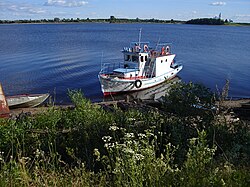
The lowest stretch of the Kubena of the length of 21 kilometres (13 mi) is listed in State Water Register of Russia as navigable, however, there is no passenger navigation.

Related Research Articles

Northern Dvina River river in Russia

The Northern Dvina is a river in northern Russia flowing through the Vologda Oblast and Arkhangelsk Oblast into the Dvina Bay of the White Sea. Along with the Pechora River to the east, it drains most of Northwest Russia into the Arctic Ocean. It should not be confused with Western Dvina.

Sukhona River river in Russia

The Sukhona is a river in the European part of Russia, a tributary of the Northern Dvina River. The course of the Sukhona lies in Ust-Kubinsky, Sokolsky, Mezhdurechensky, Totemsky, Tarnogsky, Nyuksensky, and Velikoustyugsky Districts of Vologda Oblast in Russia. It is 558 kilometres (347 mi) long, and the area of its basin 50,300 square kilometres (19,400 sq mi). The Sukhona joins the Yug near the town of Veliky Ustyug, forming the Northern Dvina, one of the biggest rivers of European Russia.

Lake Kubenskoye lake in Vologda Oblast, Russia

Lake Kubenskoye is a large and shallow lake in Vologda Oblast of Russia, situated at the height of 110.1 metres above mean sea level, stretching for 54 km from north-west to south-east.

Administratively, Vologda Oblast is divided into four cities and towns of oblast significance and twenty-six districts.

Northern Oblast (1936–1937)

Northern Oblast was an oblast of the Russian Soviet Federative Socialist Republic from 1936 to 1937. Its seat was in the city of Arkhangelsk. The oblast was located in the north of European Russia and its territory is currently divided between Arkhangelsk, Vologda, Kostroma and Kirov oblasts and the Nenets Autonomous Okrug.

Pavlovsky, Pavlovskaya, or Pavlovskoye is the name of several inhabited localities in Russia.

Northern Krai was a krai of the Russian Soviet Federative Socialist Republic from 1929 to 1936. Its seat was in the city of Arkhangelsk. The krai was located in the North of European Russia, and its territory is currently divided between Arkhangelsk, Vologda, Kostroma, and Kirov Oblasts, the Nenets Autonomous Okrug, and the Komi Republic.

Pezhma River river in Russia

The Pezhma is a river in Vozhegodsky and Verkhovazhsky Districts of Vologda Oblast and in Konoshsky and Velsky Districts of Arkhangelsk Oblast in Russia. It is a left tributary of the Vaga River. It is 137 kilometres (85 mi) long, and the area of its basin 1,450 square kilometres (560 sq mi). Its main tributary is the Semzhenga (left).

Kharovsky District District in Vologda Oblast, Russia

Kharovsky District is an administrative and municipal district (raion), one of the twenty-six in Vologda Oblast, Russia. It is located in the center of the oblast and borders with Vozhegodsky District in the north, Syamzhensky District in the east, Sokolsky District in the south, and with Ust-Kubinsky District in the west. The area of the district is 3,600 square kilometers (1,400 sq mi). Its administrative center is the town of Kharovsk. Population: 16,622 (2010 Census); 20,576 ; 25,219 (1989 Census). The population of Kharovsk accounts for 60.6% of the district's total population.

Sokolsky District, Vologda Oblast District in Vologda Oblast, Russia

Sokolsky District is an administrative and municipal district (raion), one of the twenty-six in Vologda Oblast, Russia. It is located in the center of the oblast and borders with Kharovsky and Syamzhensky Districts in the north, Totemsky District in the east, Mezhdurechensky District in the south, Vologodsky District in the southeast, and with Ust-Kubinsky District in the northwest. The area of the district is 4,100 square kilometers (1,600 sq mi). Its administrative center is the town of Sokol. Population: 12,947 (2010 Census); 14,951 ; 17,585 (1989 Census).

Syamzhensky District District in Vologda Oblast, Russia

Syamzhensky District is an administrative and municipal district (raion), one of the twenty-six in Vologda Oblast, Russia. It is located in the center of the oblast and borders with Vozhegodsky District in the north, Verkhovazhsky District in the northeast, Totemsky District in the east, Sokolsky District in the south, and with Kharovsky District in the west. The area of the district is 3,900 square kilometers (1,500 sq mi). Its administrative center is the rural locality of Syamzha. District's population: 8,745 (2010 Census); 10,384 ; 12,204 (1989 Census). The population of Syamzha accounts for 45.2% of the district's total population.

Ust-Kubinsky District District in Vologda Oblast, Russia

Ust-Kubinsky District is an administrative and municipal district (raion), one of the twenty-six in Vologda Oblast, Russia. It is located in the center of the oblast and borders with Vozhegodsky District in the north, Kharovsky District in the northeast, Sokolsky District in the southeast, Vologodsky District in the southwest, and with Kirillovsky District in the west. The area of the district is 2,400 square kilometers (930 sq mi). Its administrative center is the rural locality of Ustye. District's population: 8,094 (2010 Census); 9,350 ; 11,280 (1989 Census). The population of Ustye accounts for 48.7% of the district's population.

Vologodsky District District in Vologda Oblast, Russia

Vologodsky District is an administrative and municipal district (raion), one of the twenty-six in Vologda Oblast, Russia. It is located in the center of the oblast and borders with Ust-Kubinsky and Sokolsky Districts in the northeast, Mezhdurechensky District in the east, Gryazovetsky District in the southeast, Poshekhonsky District of Yaroslavl Oblast in the southwest, Sheksninsky District in the west, and with Kirillovsky District in the northwest. The area of the district is 4,500 square kilometers (1,700 sq mi). Its administrative center is the city of Vologda. Population: 50,438 (2010 Census); 50,956 ; 64,946 (1989 Census). As of 2010, Vologodsky District was the most populous among all the districts of Vologda Oblast.

Vozhegodsky District District in Vologda Oblast, Russia

Vozhegodsky District is an administrative and municipal district (raion), one of the twenty-six in Vologda Oblast, Russia. It is located in the north of the oblast and borders with Konoshsky District of Arkhangelsk Oblast in the north, Verkhovazhsky District in the east, Syamzhensky District in the southeast, Kharovsky District in the south, Ust-Kubinsky District in the southwest, and with Kirillovsky District in the west. The area of the district is 5,500 square kilometers (2,100 sq mi). Its administrative center is the urban locality of Vozhega. Population: 16,790 (2010 Census); 18,976 ; 22,470 (1989 Census). The population of Vozhega accounts for 40.1% of the district's total population.

Vozhega River river in Vozhegodsky District

The Vozhega is a river in Vozhegodsky District in the north of Vologda Oblast in Russia, a tributary of Lake Vozhe. The Vozhega belongs to the river basin of the Onega River. It is 140 kilometres (87 mi) long, and the area of its basin 1,980 square kilometres (760 sq mi). The urban-type settlement of Vozhega, the administrative center of Vozhegodsky District, is located close to the river in its middle course on the right bank. Both the settlement and the district have their names originating from the name of the river. The main tributary of the Vozhega is the Chuzhga (right).

The Syamzhena is a river in Sokolsky and Syamzhensky Districts of Vologda Oblast in Russia. It is a left tributary of the Kubena River. It is 117 kilometres (73 mi) long, and the area of its basin 1,930 square kilometres (750 sq mi). Its main tributaries are the Shichenga (right) and the Bolshoy Pungul (right). The center of Syamzhensky District, the selo of Syamzha, is located on both banks of the Syamzhena.

Dvinitsa River river in Russia

The Dvinitsa is a river in Kharovsky, Sokolsky, and Mezhdurechensky Districts of Vologda Oblast in Russia. It is a left tributary of the Sukhona River. It is 174 kilometres (108 mi) long, and the area of its basin 2,400 square kilometres (930 sq mi). The main tributaries of the Dvinitsa are the Shorega, the Korbanga, and the Votcha.

Tarasovsky, Tarasovskaya, or Tarasovskoye is the name of several rural localities in Russia:

References

  1. 1 2 3 Кубена. Great Soviet Encyclopedia.