
The Kumeyaay, also known as 'Iipai-Tiipai or by the historical Spanish name Diegueño, is a tribe of Indigenous peoples of the Americas who live at the northern border of Baja California in Mexico and the southern border of California in the United States. They are an indigenous people of California.
Mission Trails Regional Park is a 7,220-acre (29.2 km2) open space preserve within the city of San Diego, California, established in 1974. It is the sixth-largest municipally owned park in the United States, and the largest in California.

The Cleveland National Forest encompasses 460,000 acres/720 sq mi (1,900 km2) of inland montane regions—approx. 60 miles from the Pacific Ocean—within the counties of San Diego, Riverside, and Orange, California. The landscape varies somewhat, with mostly chaparral canyons, arroyos and high desert, but dotted with meadows and oak and conifer forests. Near water sources, riparian environments and perennial aquatic plants attract native and migratory wildlife, such as at San Diego’s man-made Lake Cuyamaca. A generally warm and dry, inland-Mediterranean climate prevails over the forest, with the cooler months producing morning frost and snowfall. It is the southernmost U.S. National Forest of California. The area is administered by the U.S. Forest Service, a government agency within the United States Department of Agriculture, and is locally overseen by the Descanso, Palomar and Trabuco Ranger Districts.

Cuyamaca Rancho State Park is a state park in inland San Diego County, Southern California, United States, located 40 miles (64 km) east of the metropolitan are of San Diego. The park is situated near the southernmost reaches of the vast Cleveland National Forest, as well as the Cuyamaca and Laguna Mountains of the Peninsular Ranges. The park's 26,000 acres (11,000 ha) of land features pine, fir, and oak forests, interspersed with meadows, creeks and streams that exist due to the relatively high elevation of the area when compared to its surroundings. The park includes the 6,512-foot (1,985 m) Cuyamaca Peak, the second-highest point in San Diego County.

Lake Murray is a reservoir in San Diego, California, operated by the City of San Diego's Public Utilities Department. Although thinly divided by a few housing communities and select roadways, it is technically considered to be part of the jurisdiction which makes up Mission Trails Regional Park. When full, the reservoir covers 171.1 acres (69.2 ha), has a maximum water depth of 95 feet (29 m), and a shoreline of 3.2 miles (5.1 km). The asphalt-paved service road lining roughly two-thirds of the lake's perimeter is a popular recreation site for the Navajo community as well as residents of the northernmost neighborhoods in La Mesa. It lies south of Cowles Mountain and a small golf course. It also functions as an important aeronautical reporting point for aircraft inbound to land at Montgomery-Gibbs Executive Airport.
Black Mountain Open Space Park is a city park located in the suburbs of San Diego, California.
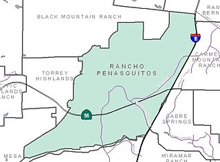
Rancho Peñasquitos is a suburban community in the northeastern part of the city of San Diego, California. It is named after the first Mexican land grant in the county, Rancho Santa Maria de Los Peñasquitos. The community abuts Los Peñasquitos Canyon Preserve, an open space preserve that offers hiking, biking, and equestrian trails. The community is commonly abbreviated "PQ."

Mission Indians are the indigenous peoples of California who lived in Southern California and were forcibly relocated from their traditional dwellings, villages, and homelands to live and work at 15 Franciscan missions in Southern California and the Asistencias and Estancias established between 1796 and 1823 in the Las Californias Province of the Viceroyalty of New Spain.
Elfin Forest is an unincorporated residential community of San Diego County, California, United States, in the foothills of the Santa Rosa Mountains. The community is southwest of Escondido and according to the USGS it is located at 33°04′25″N117°09′51″W in the Escondido ZIP code of 92029. It borders the rural, unincorporated town of Harmony Grove to the northeast, San Marcos to the north and west, Olivenhain to the southwest, and Rancho Santa Fe to the south.

The Jamul Indian Village of California is a federally recognized tribe of Kumeyaay Indians, who are sometimes known as Mission Indians.

The San Pasqual Band of Diegueño Mission Indians of California is a federally recognized tribe of Kumeyaay people, who are sometimes known as Mission Indians.

The Manzanita Band of Diegueño Mission Indians of the Manzanita Reservation is a federally recognized tribe of Kumeyaay Indians, who are sometimes known as part of the Mission Indians.

Chollas Creek is an urban creek in San Diego County, California, United States, that drains to the San Diego Bay. It is also referred to as Las Chollas Creek. Chollas Creek arises in Lemon Grove and La Mesa, where its four branches begin. It empties into the Bay at Barrio Logan. The creek is 30 mi (48 km) long. The creek splits into two main forks and may be dry during the Southern California dry season. Multiple plant, animal, and aquatic wildlife species live in or around the creek, including the rare plants Juncus acutus leopoldii and Iva hayesiana, and the threatened Coastal California gnatcatcher.
Silverwood Wildlife Sanctuary is a nature preserve owned and operated by the San Diego Audubon Society (SDAS). Silverwood was set up in 1965 to preserve coastal chaparral and riparian woodland habitats. It is also a nature education facility for San Diego area schoolchildren and adults, and functions as part of a wildlife migration corridor.

Wildwood Regional Park is a suburban regional park in the western Simi Hills and Conejo Valley, in Ventura County, California. It is located in western Thousand Oaks, northern Newbury Park, and southern Moorpark.
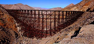
Goat Canyon Trestle is a wooden trestle in San Diego County, California. At a length of 597–750 feet (182–229 m), it is the world's largest all-wood trestle. Goat Canyon Trestle was built in 1933 as part of the San Diego and Arizona Eastern Railway, after one of the many tunnels through the Carrizo Gorge collapsed. The railway had been called the "impossible railroad" upon its 1919 completion. It ran through Baja California and eastern San Diego County before ending in Imperial Valley. The trestle was made of wood, rather than metal, due to temperature fluctuations in the Carrizo Gorge. By 2008, most rail traffic stopped using the trestle.
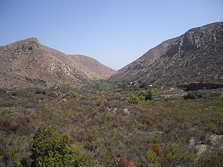
Goat Canyon is a valley in San Diego County, California, United States, located within the Carrizo Gorge in the Jacumba Mountains. The rock forming the canyon is crystalline basement. One feature of the canyon is a dry waterfall. The canyon is bridged by a wooden railroad trestle, the Goat Canyon Trestle, which is the world's largest curved all-wood trestle. The canyon is accessible by trail by traveling west from Mortero Palms.
Jerry Schad was an American educator and nonfiction writer, who had extensively documented local hiking trails in San Diego, Orange County and Southern California.

Lake Poway is a dam and reservoir in Poway, California, United States. The dam is owned by the City of Poway and was constructed between 1970 and 1972 with the purpose of storing and supplying water, and providing recreational facilities to the community. A $3.2-million bond issue for construction of the dam was rejected by voters in 1964 and 1966, but passed with 87 percent in favor in 1969. Year-round fishing for trout, bass, catfish, sunfish and bluegill is available at the lake.

Woodson Mountain, or widely known as Mount Woodson is a mountain near Poway, California and is known for Potato Chip Rock which located to the west of the summit.

