
Anantapur, officially Anantapuramu, is a city in Anantapur district of the Indian state of Andhra Pradesh. It is the mandal headquarters of Anantapuru mandal and also the divisional headquarters of Anantapur revenue division. The city is located on National Highway. It was also the headquarters of the Datta Mandalam in 1799. It was also a position of strategic importance for the British Indian Army during the Second World War.

Kalyandurg is a town in Anantapur district of the Indian state of Andhra Pradesh. It is the headquarters for Kalyandurg mandal and Kalyandurg revenue division. The discovery of diamond-bearing Kimberlites in Kalyandurg area, is one of the clusters that has been discovered.

Anantapur district, officially Anantapuramu district, is one of the eight districts in the Rayalaseema region of the Indian state of Andhra Pradesh. The district headquarters is located in Anantapur city. It is one of the driest places in South India. In the year 2022, as part of re-organisation of districts, Sri Sathya Sai district was carved out.

Penukonda also called Penugonda is a town in the Sri Sathya Sai district of Andhra Pradesh, India. It is 70 km away from Anantapur town.
Kadiri is a major city in Sri Sathya Sai District the Indian state of Andhra Pradesh. It is a Special Grade Municipal City Council and headquarters of Kadiri Mandal and Kadiri Revenue Division. Kadiri Taluka ('Tehsil') was the largest taluk in the state of Andhra Pradesh when there was taluka system in Andhra Pradesh Kadiri is known for its jasmine and saffron flowers. Kadiri saffron is widely sold in Andhra and Karnataka. The Sri Lakshmi Narasimhaswamy Temple is reminiscent of Kadiri to the people of Karnataka, Telangana And Tamil Nadu. The name of Kadiri has also some interesting past. The habitation was initially named as Khadripuram as ‘khadara’ plants were largely found in the surrounding forests and Khadri has later transformed as Kadiri.

Hindupuram is a city in Sri Sathya Sai district of the Indian state of Andhra Pradesh. It is located to the edge of the Andhra–Karnataka border and is the headquarters of Hindupuram mandalam. Hindupuram is the Parliamentary Constituency in the newly formed District Sri Sathya Sai. It is located about 67 km from district headquarters Puttaparthi, 100 km from Bengaluru the capital of Karnataka, 95 km From Kadiri.
Bathalapalle is a village in Sri Sathya Sai district of the Indian state of Andhra Pradesh. It is the mandal headquarters of Bathalapalle mandal in Dharmavaram revenue division. It is about 25 kilometres south east of Anantapur on National Highway 205.

Nagalapuram is a Mandal Headquarter in Tirupati district of the Indian state of Andhra Pradesh. It is the mandal headquarters of Nagalapuram mandal in Srikalahasti revenue division. This town is home to Vedanarayana Temple, where the presiding deity Vishnu is in the form of Matsya, the first incarnation of Dasavatara.
Pedakakani is a village in the Guntur district of the Indian state of Andhra Pradesh. It is located in Pedakakani mandal of Guntur revenue division. Hindu shrine of Shiva, Sri Bhramaramba Malleswara Swamy Temple is located in the village.
Narpala is a village in Anantapur district of the Indian state of Andhra Pradesh. It is the mandal headquarters of Narpala mandal in Anantapur revenue division. Narpala is located 23 km from Anantapur. Famous Gugudu kullai swamy temple is in Narpala Mandal only.
Tadimarri is a village in Sri Sathya Sai district of the Indian state of Andhra Pradesh. It is the mandal headquarters of Tadimarri mandal in Dharmavaram revenue division.
Ramagiri is a village in Sri Sathya Sai district of the Indian state of Andhra Pradesh. It is the mandal headquarters of Ramagiri mandal in Dharmavaram revenue division.
Madakasira is a town with a population 19,432 in 2001 and also a mandal in Sri Satya Sai district in the state of Andhra Pradesh in India. It is located near the state border with Karnataka. The Madakasira Hill Fort in the town is a centrally protected monument of national importance.
Parigi is a village in Sri Sathya Sai district in the state of Andhra Pradesh in India.
Amadagur is a village in Sri Sathya Sai district of the Indian state of Andhra Pradesh. It is the headquarters of Amadagur mandal in Kadiri revenue division. According to 2011 census of India, Total Amadagur population is 29,520 people are living in this Mandal, of which 14,704 are male and 14,816 are female. Population of Amadagur in 2020 is 35,424 Literate people are 15,309 out of 9,169 are male and 6,140 are female. Total workers are 16,599 depends on multi skills out of which 8,878 are men and 7,721 are women. Total 5,032 Cultivators are depended on agriculture farming out of 3,295 are cultivated by men and 1,737 are women. 6,755 people works in agricultural land as a labour in Amadagur, men are 3,135 and 3,620 are women.
Gorantla is a village and mandal headquarters on the banks of the Chitravathi River in the Sri Sathya Sai district of the state of Andhra Pradesh, India. The village is around 120 km from Bengaluru and is well-connected with National Highway 44 (India). Gorantla is home to the historical Madhavaraya Temple built in the year 1354 A.D. by Narasimha Saluva of the Vijaya Nagar Empire. This temple ranks first among centrally protected monuments of national importance. The city is also known for its silk sarees, masala dosa and more.
Somandepalle is a census town in Sri Sathya Sai district of the Indian state of Andhra Pradesh. It is located in Somandepalle mandal of Penukonda revenue division. The town is a constituent of Anantapur urban agglomeration.
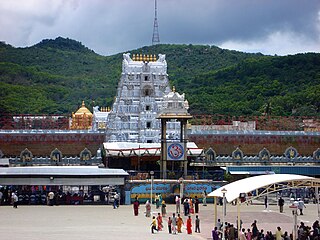
Tirupati district is one of the eight districts of Rayalaseema region in the Indian state of Andhra Pradesh. The district headquarters is located at Tirupati city. This district is known for its numerous historic temples, including the Hindu shrine of Tirumala Venkateswara Temple and Sri Kalahasteeswara temple. The district is also home to Satish Dhawan Space Centre, a rocket launch centre located in Sriharikota. The river Swarnamukhi flows through Tirupati, Srikalahasti, Naidupeta, Vakadu and join into the Bay of Bengal.

Nandyal district is a district in the Indian state of Andhra Pradesh with Nandyal as its administrative headquarters, it was formed on 4 April 2022 to become one of the resultant 26 districts. It is part of the Rayalaseema region. The district consists of Nandyal revenue division and a newly formed Dhone revenue division and Atmakur revenue division from Kurnool district.

Sri Sathya Sai district is a district in the Indian state of Andhra Pradesh. Its headquarters is at Puttaparthi. It was formed on 4 April 2022 from parts of the erstwhile Anantapur district.
Historical Temples: Kota Lashmi Narasimha swamy Temple, Sri Ramalayam Temple, Sri Venkateswara Swamy Temple, Dharg.


