
Gamla stan, until 1980 officially Staden mellan broarna, is the old town of Stockholm, Sweden. Gamla stan consists primarily of the island Stadsholmen. Officially, but not colloquially, Gamla stan includes the surrounding islets Riddarholmen, Helgeandsholmen and Strömsborg. It has a population of approximately 3,000.
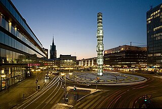
Sergels torg is a major public square in Stockholm, Sweden, constructed in the 1960s and named after 18th-century sculptor Johan Tobias Sergel, whose workshop was once located north of the square.

Hötorget (Haymarket) is a city square in the center of Stockholm, Sweden that has been transitioning since the Early Medieval Period.

PUB was one of the major department stores in Stockholm, Sweden, located in two buildings at Hötorget, Stockholm city center. PUB was opened in 1882 and rapidly expanded. The name PUB is for the initials of Paul Urbanus Bergström, the founder of the store, who owned a great deal of buildings and business in the area.

Gustav Adolfs torg is a public square in central Stockholm, Sweden.

Rådmansgatan is an underground station on the Green line of the Stockholm metro. It lies below Sveavägen between its junctions with Rådmansgatan and Rehnsgatan in the district of Vasastaden and borough of Norrmalm in central Stockholm. The station has a single island platform, some 8 metres (26 ft) below street level, and is accessed via a pair of ticket halls at each end of the station. The ticket halls are accessed via staircases and lifts from the street above.

Järntorget is a small public square in Gamla stan, the old town in central Stockholm, Sweden. Located in the southernmost corner of the old town, the square connects the thoroughfares Västerlånggatan and Österlånggatan, while the two alleys, Södra Bankogränd and Norra Bankogränd, stretches east to connect the square to Skeppsbron, and two other alleys, Järntorgsgatan and Triewaldsgränd, leads south to Slussplan and Kornhamnstorg respectively.

Sveavägen is a major street in Stockholm, Sweden.

Kungsbron is a double bridge in central Stockholm, Sweden. Stretching over Klara Sjö, it connects Norrmalm to Kungsholmen.

Malmskillnadsgatan is a 650-metre long street in central Stockholm, Sweden. It stretches northward from the Brunkebergstorg square over Hamngatan; crosses Mäster Samuelsgatan and Oxtorgsgatan; passes over the bridge Malmskillnad Bridge passing over Kungsgatan; crosses Brunnsgatan and David Bagares gata; and finally ends at Johannes plan near Döbelnsgatan.

Malmskillnadsbron is an arch bridge in central Stockholm, Sweden. It takes the street Malmskillnadsgatan over Kungsgatan flanked on its east side by two Art Deco towers called Kungstornen. For an explanation of Malmskillnad, see Malmskillnadsgatan.

Regeringsgatans bro or more correctly Regeringsgatans viadukt över Kungsgatan is a bridge in central Stockholm, Sweden, taking the street Regeringsgatan over Kungsgatan. It was inaugurated in 1910.

Västerlånggatan is a street in Gamla stan, the old town of Stockholm, Sweden. Stretching southward between the squares Mynttorget and Järntorget, it follows the course of the city's now demolished 13th-century defensive wall.

Drottninggatan in Stockholm, Sweden, is a major pedestrian street. It stretches north from the bridge Riksbron at Norrström, in the district of Norrmalm, to Observatorielunden in the district of Vasastaden.
Kungsgatan is a common name for major streets in Swedish cities, the three most well-known being:

Vasagatan is a major street in central Stockholm named after King Gustav Vasa.

The Hötorget buildings are five high-rise office buildings in Stockholm, Sweden. Located between the squares Hötorget and Sergels Torg in the central Norrmalm district, they stand 72 m (236 ft) tall and are a clearly visible landmark.

Hötorget, formerly known as Kungsgatan, is an underground station on the Green line of the Stockholm metro. It is situated near to the Hötorget square in the borough of Norrmalm in central Stockholm, and lies below Sveavägen between its junctions with Oxtorgsgatan and Apelbergsgatan. The station has three entrances, one at each end and one in the middle from Kungsgatan. The central entrance includes an underground square with several shops and stores. The distance to Slussen is 1.5 km (0.93 mi).
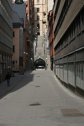
Tunnelgatan is a street in Stockholm, Sweden, which stretches from Sveavägen to the Brunkeberg Tunnel.

The following outline is provided as an overview of and topical guide to Stockholm:

