
The Altai Mountains, also spelled Altay Mountains, are a mountain range in Central Asia and Eastern Asia, where Russia, China, Mongolia, and Kazakhstan converge, and where the rivers Irtysh and Ob have their headwaters. The massif merges with the Sayan Mountains in the northeast, and gradually becomes lower in the southeast, where it merges into the high plateau of the Gobi Desert. It spans from about 45° to 52° N and from about 84° to 99° E.

The Longmen Grottoes or Longmen Caves are some of the finest examples of Chinese Buddhist art. Housing tens of thousands of statues of Shakyamuni Buddha and his disciples, they are located 12 kilometres (7.5 mi) south of present-day Luoyang in Henan province, China. The images, many once painted, were carved as outside rock reliefs and inside artificial caves excavated from the limestone cliffs of the Xiangshan (香山) and Longmenshan, running east and west. The Yi River flows northward between them and the area used to be called Yique. The alternative name of "Dragon's Gate Grottoes" derives from the resemblance of the two hills that check the flow of the Yi River to the typical "Chinese gate towers" that once marked the entrance to Luoyang from the south. There are as many as 100,000 statues within the 2,345 caves, ranging from 1 inch (25 mm) to 57 feet (17 m) in height. The area also contains nearly 2,500 stelae and inscriptions, hence the name "Forest of Ancient Stelae", as well as over sixty Buddhist pagodas. Situated in a scenic natural environment, the caves were dug from a 1 kilometre (0.62 mi) stretch of cliff running along both banks of the river. 30% date from the Northern Wei and 60% from the Tang dynasty, caves from other periods accounting for less than 10% of the total. Starting with the Northern Wei dynasty in 493 AD, patrons and donors included emperors, Wu Zetian, members of the royal family, other rich families, generals, and religious groups.

The Yungang Grottoes, formerly the Wuzhoushan Grottoes, are ancient Chinese Buddhist temple grottoes built during the Northern Wei dynasty near the city of Datong, then called Pingcheng, in the province of Shanxi. They are excellent examples of rock-cut architecture and one of the three most famous ancient Buddhist sculptural sites of China. The others are Longmen and Mogao.

Jökulsárlón is a large glacial lake in southern part of Vatnajökull National Park, Iceland. Situated at the head of the Breiðamerkurjökull glacier, it developed into a lake after the glacier started receding from the edge of the Atlantic Ocean. The lake has grown since then at varying rates because of melting of the glaciers. The glacial front is now about 8 km (5.0 mi) away from the ocean's edge and the lake covers an area of about 18 km2 (6.9 sq mi). In 2009 it was reported to be the deepest lake in Iceland, at over 284 m (932 ft), as glacial retreat extended its boundaries. The size of the lake has increased fourfold since the 1970s.

The Chusovaya is a river flowing in Perm Krai, Sverdlovsk Oblast and Chelyabinsk Oblast of Russia. A tributary of the Kama, which in turn is a tributary of the Volga, discharges into the Chusovskoy Cove of the Kamsky Reservoir. The river is remarkable in that it originates on the eastern slopes of the Ural Mountains in Asia, crosses the mountains, and mostly runs on their western slopes in Europe. The Chusovaya River is widely used as a source of water. In particular, its water is taken from the Volchikhinsky Reservoir, 37 square kilometres (14 sq mi), to the Verkhneisetsky Reservoir to supply the major city of Yekaterinburg. Fifteen smaller reservoirs are spread over about 150 tributaries of the river.

The Sylva is a river in Sverdlovsk Oblast and Perm Krai in Russia. It is 493 kilometres (306 mi) in length. The area of the basin is 19,700 square kilometres (7,600 sq mi). The Sylva flows into the Chusovoy Cove of the Kama Reservoir. It freezes up in November and stays under the ice until April. Principal tributaries: Iren, Babka, Irgina, Vogulka (left); Barda, Shakva (right). Main port: Kungur.
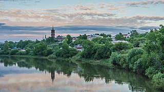
Kungur is a town in the southeast of Perm Krai, Russia, located in the Ural Mountains at the confluence of the rivers Iren and Shakva with the Sylva. Population: 66,074 (2010 Census); 68,943 (2002 Census); 81,402 (1989 Soviet census); 64,800 (1959); 36,000 (1939).

Phong Nha-Kẻ Bàng is a national park and UNESCO World Heritage Site in the Bố Trạch and Minh Hóa districts of central Quảng Bình Province in the North Central Coast region of Vietnam, about 500 km south of Hanoi. The park borders the Hin Namno National Park in Khammouane Province, Laos to the west and 42 km east of the East sea from its borderline point. Phong Nha-Kẻ Bàng National Park is in a limestone zone of 2,000 km2 in Vietnamese territory and borders another limestone zone of 2,000 km2 of Hin Namno in Laotian territory. The core zone of this national park covers 857.54 km2 and a buffer zone of 1,954 km2.
The Jenolan Caves are limestone caves located within the Jenolan Karst Conservation Reserve in the Central Tablelands region, west of the Blue Mountains, in Jenolan, Oberon Council, New South Wales, in eastern Australia. The caves and 3,083-hectare (7,620-acre) reserve are situated approximately 175 kilometres (109 mi) west of Sydney, 20 kilometres (12 mi) east of Oberon and 30 kilometres (19 mi) west of Katoomba. Dating back to 340million years ago, it is the oldest known and dated open cave system in the world.

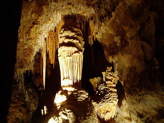
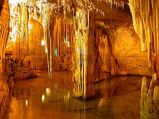
A show cave—also called tourist cave, public cave, and, in the United States, commercial cave—is a cave which has been made accessible to the public for guided visits.

The Jeita Grotto is a system of two separate, but interconnected, karstic limestone caves spanning an overall length of nearly 9 kilometres (5.6 mi). The caves are situated in the Nahr al-Kalb river valley within the locality of Jeita, 18 kilometres (11 mi) north of the Lebanese capital Beirut. Though inhabited in prehistoric times, the lower cave was not rediscovered until 1836 by Reverend William Thomson; it can only be visited by boat since it channels an underground river that provides fresh drinking water to more than a million Lebanese.
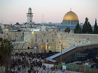
Tourism in Israel is a major economic sector and a significant source of national income. Israel offers a plethora of historical and religious sites, beach resorts, natural sites, archaeological tourism, heritage tourism, adventure tourism, and ecotourism. For practical reasons, this article also covers tourism in the West Bank and the Golan Heights, since it is closely interconnected with the mass tourism in Israel. In 2019, Israel saw a record 4.55 million tourist arrivals, with tourism contributing NIS 20 billion to the national economy in 2017.

Đồng Hới is the capital city of Quảng Bình Province in the north central coast of Vietnam. The city's area is 155.71 km2 (60.12 sq mi). Population as per the 2019 census was 133,672. It is served by National Highway 1A, the Đồng Hới Railway Station, and airport. By road, Đồng Hới is 486 kilometres (302 mi) south of Hanoi, 195 kilometres (121 mi) south of Vinh, 160 kilometres (99 mi) north of Huế and 1,204 kilometres (748 mi) north of Hồ Chí Minh City. It borders Quảng Ninh District on the west and south, the South China Sea on the east, Bố Trạch District on the north.

The Waitomo Glowworm Caves attraction is a cave at Waitomo on the North Island of New Zealand. It is known for its population of Arachnocampa luminosa, a glowworm species found exclusively in New Zealand. This cave is part of the waitomo streamway system that includes the Ruakuri Cave, Lucky Strike, and Tumutumu Cave.

The Flaming Mountains or HuoyanMountains, are barren, eroded, red sandstone hills in the Tian Shan of Xinjiang. They lie near the northern rim of the Taklamakan Desert and east of the city of Turpan. Their striking gullies and trenches caused by erosion of the red sandstone bedrock give the mountains a flaming appearance at certain times of the day.

The Belum Caves, located in Nandyala district of Andhra Pradesh's Rayalaseema region, is the second largest cave system on the Indian subcontinent, known for its speleothems, such as stalactite and stalagmite formations. The Belum Caves have long passages, galleries, spacious caverns with fresh water and siphons. This cave system was formed over the course of tens of thousands of years by the constant flow of underground water from the now-disappeared river Chitravathi. The cave system reaches its deepest point at the point known as Pataalaganga. Belum Caves have a length of 3,229 m (10,593.8 ft), making them the second largest caves on the Indian Subcontinent after the Krem Liat Prah caves in Meghalaya. It is one of the centrally protected Monuments of National Importance.
Neptune's Grotto is a stalactite cave near the town of Alghero on the island of Sardinia, Italy. The cave was discovered by local fishermen in the 18th century and has since developed into a popular tourist attraction. The grotto gets its name from the Roman god of the sea, Neptune.

The Lummelunda Cave is located in a nature reserve at Lummelunda north of Visby on Gotland, Sweden. The explored part of this karst cave is almost 4.5 km (2.8 mi), making it one of the longest caves in Sweden. It is created by the drainage water from the Martebo mire. The water forms a stream with its outlet in the Baltic Sea. In the 15th to 19th centuries, mills and an ironwork were set up by the stream.

Shorsky National Park is a forested, mountainous area in southwestern Siberia, where the West Siberian Plain meets the South Siberian Mountains. It is representative of areas with dark taiga tree cover. With an area of 1,614 square miles (4,180 km2), the park covers over a third of Tashtagolsky District at the southern end of Kemerovo Oblast, about 300 kilometres (190 mi) south of the city of Kemerovo. The area is the home of the Shors people, and has historically been associated with mining and logging industries before being established as a protected area in 1989.
Lipa Cave is a karst cave situated close to Cetinje, Montenegro. It has a system of about 2.5 kilometres (1.6 mi) of passages and halls, which makes it one of the largest caves in Montenegro. It's the first cave in Montenegro which opened for tourists, after the cave's valorisation projected finished thanks to the help of the Municipality of Cetinje and the Lipa Cave company.


