
The Huari Province is one of twenty provinces of the Ancash Region in Peru. Its seat is Huari.
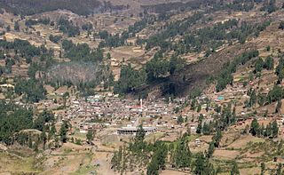
Huari is one of the 16 districts that integrates the Peruvian province of Huari in the Ancash region. The district consists of the city of Huari, 15 small villages and 22 annexes.
Cajay District is one of sixteen districts of the Huari Province in Peru.
Challwaqucha may refer to:
Markahirka or Marka Hirka is an archaeological site with cave paintings and stone tombs (chullpa) on a mountain of the same name in Peru. It is located in the Ancash Region, Huari Province, in the districts of Cajay and Masin. It is situated at a height of 3,580 metres (11,745 ft). Markahirka is also a good viewpoint with views into the Puchka valley (Puchca) and to the towns of Huari (Wari) and Huachis (Wachis).

Waraqayuq or Warak'ayuq is a mountain with an archaeological site of the same name in the Cordillera Blanca in the Andes of Peru, about 4,600 metres (15,092 ft) high. It is situated in the Ancash Region, Huari Province, Chavin de Huantar District, east of the mountain Yanamaray.
Pukarahu or Puka Rahu may refer to:
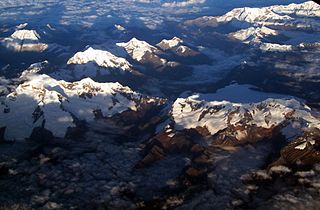
Auqui is a mountain in the Cordillera Blanca in the Andes of Peru, about 4,800 m (15,748 ft) high. It is situated in the Ancash Region, Huari Province, Huari District. Auqui lies southeast of Jacabamba.
Pucaraju is a mountain in the Cordillera Blanca in the Andes of Peru, about 4,800 m (15,748 ft) high. It is situated in the Ancash Region, Huari Province, Huari District. Pucaraju lies on a ridge east of Jacabamba.
Arteza is a mountain in the Cordillera Blanca in the Andes of Peru, about 5,000 metres (16,404 ft) high. It is situated in the Ancash Region, Huari Province, Huantar District. Arteza lies at the Qarwakancha valley, southeast of Andavite and Cayesh and northeast of Qarwakancha and Maparaju.
Quisuargaga or Kiswar Qaqa is a mountain in the Andes of Peru, about 4,400 m (14,436 ft) high. It is situated in the Ancash Region, Huari Province, Huari District. Quisuargaga lies on the eastern border of the buffer zone of the Huascarán National Park.

Matagaga is a mountain on the eastern extensions of the Cordillera Blanca in the Andes of Peru, about 4,400 metres (14,436 ft) high. It is situated in the Ancash Region, Huari Province, Chavin de Huantar District. Mata Qaqa lies east of the Rangracancha valley and northeast of the Challhua valley. The Mosna River flows along its northern slopes.
Yanaccacca is a mountain in the Cordillera Blanca in the Andes of Peru which reaches a height of approximately 4,200 m (13,780 ft). It is located in the Ancash Region, Huari Province, Huari District, southwest of Huari. The Rurichinchay River flows along its southern slope.
Kuntur Tuqllana is a mountain in the Andes of Peru which reaches a height of approximately 4,400 m (14,400 ft). It is located in the Ancash Region, Huari Province, Chana District.
Putaqa Hirka is a mountain in the eastern extensions of the Cordillera Blanca in the Andes of Peru which reaches a height of approximately 4,200 m (13,800 ft). It is located in the Ancash Region, Huari Province, on the border of the districts of Cajay and Masin.
Runtuy is a mountain in the eastern extensions of the Cordillera Blanca in the Andes of Peru which reaches a height of approximately 4,000 m (13,000 ft). It is located in the Ancash Region, Huari Province, Huari District, northwest of Huari.
Quinuajirca or Kinwa Hirka is a mountain in the eastern extensions of the Cordillera Blanca in the Andes of Peru which reaches a height of approximately 4,400 m (14,400 ft). It is located in the Ancash Region, Huari Province, Huari District. Quinuajirca lies at the Rurichinchay valley, northeast of the peak of Chinchey.
Jatunjirca is a mountain in the eastern part of the Cordillera Blanca in the Andes of Peru which reaches a height of approximately 3,800 m (12,500 ft). It is located in the Ancash Region, Huari Province, Huari District, southwest of Huari and west of the village of Yacya.
Waman Wayi is a mountain in the Andes of Peru which reaches a height of approximately 4,400 m (14,436 ft). It is located in the Ancash Region, Huari Province, San Marcos District.


