
Quispicanchi Province is one of thirteen provinces in the Cusco Region in the southern highlands of Peru.
Accha District is one of nine districts of the province Paruro in Peru.

Wanakawri is an archaeological site and a legendary mountain in Peru. It is situated in the Cusco Region, Cusco Province, in the districts San Jerónimo and San Sebastián, and in the Paruro Province, Yaurisque District. The mountain with the archaeological remains is 4,089 metres (13,415 ft) high and one of the highest elevations near Cusco.

Araway Qhata which further to the south is named Kunturuma is a mountain in the south of the city of Cusco in Peru. It lies in the Cusco Region, Cusco Province, Santiago District. The words Viva El Perú Glorioso have been carved into the mountain side in large letters so that they can be read from the city below.
Kuntur Sinqa is a viewpoint in Peru. It is situated in the Cusco Region, La Convención Province, Echarate District. The viewpoint is a kind of balcony made out of concrete and metal which runs around a rock. It lies about 500 metres (1,640 ft) above the Turuntuypata River (Torontoypata) and it is about 100 metres (328 ft) long. The balcony of Kuntur Sinqa is considered one of the outstanding works of engineering of the Cusco Region.

Kuntur Sinqa is a mountain in the Andes of Peru. It is located in the Ayacucho Region, Huanta Province, Luricocha District. Kuntur Sinqa lies on the right bank of the Mantaro River, east of San Miguel de Mayocc and southwest of San José de Secce.
Kuntur Sinqa may refer to:

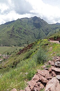
Inti Watana or Intiwatana (Quechua) is an archaeological site in Peru. It lies in the Cusco Region, Calca Province, Pisac District.

Qañawimayu which upstream is called Cayacti and downstream successively is named Jaraucata, Qullpa(Collpa), Yawina(Yavina) and Santo Tomás River is a river in Peru. It is located in the Apurímac Region, Cotabambas Province, and in the Cusco Region, Chumbivilcas Province and Paruro Province. It belongs to the Apurímac watershed.
Machu Kuntur Sinqa or Machu Kuntur Sankha is a mountain in the Cusco Region in Peru, about 4,200 metres (13,780 ft) high. It is situated in the Calca Province, on the border of the districts Pisac and San Salvador. Machu Kuntur Sinqa lies on the right bank of the Willkanuta River, near the archaeological park of Pisac.
Ichhunayuq is a mountain in the Andes of Peru, about 4,200 metres (13,780 ft) high. It is located in the Cusco Region, Calca Province, on the border of the districts of Coya and Pisac. Ichhunayuq lies at the archaeological site of Písac, northwest of the town.
Condorsenja is mountain in the northern extensions of the Vilcanota mountain range in the Andes of Peru, about 4,800 metres (15,748 ft) high. It is located in the Cusco Region, Quispicanchi Province, on the border of the districts of Ccarhuayo and Ocongate. The mountain lies southwest of Jolljepunco and Cinajara where the annual Quyllu Rit'i festival takes place. Yuracjaja and Jajachaca are southeast of Condorsenja.
Kuntur Wamani is a mountain in the Chunta mountain range in the Andes of Peru, about 4,800 metres (15,748 ft) high. It is located in the Huancavelica Region, Castrovirreyna Province, Santa Ana District, and in the Huancavelica Province, Huancavelica District. Kuntur Wamani lies southeast of Wamanrasu, northwest of Qarwarasu and northeast of Antarasu.
Kuntur Wamani is a mountain in the Chunta mountain range in the Andes of Peru, about 4,800 metres (15,748 ft) high. It is situated in the Huancavelica Region, Castrovirreyna Province, Santa Ana District. Kuntur Wamani lies southwest of Qarwarasu.
Kuntur Sinqa is a mountain in the Cordillera Blanca in the Andes of Peru, about 4,630 m (15,190 ft) high. It is situated in the Ancash Region, Recuay Province, Catac District. Kuntur Sinqa lies west of Mururahu at a lake named Qishqiqucha.

Yuaytacondorsenja is a 5,345-metre-high (17,536 ft) mountain in the Chila mountain range in the Andes of Peru. It is located in the Arequipa Region, Castilla Province, Chachas District. Yuaytacondorsenja lies northwest of Chila and Chila Pillune. It is situated at the end of a valley named Puncuhuaico. Its stream flows to Chachas Lake.
Kuntur Salla is a 5,003-metre-high (16,414 ft) mountain in the Andes of Peru. It is located in the Arequipa Region, Condesuyos Province, Cayarani District.
Kuntur Sinqa is a mountain in the Andes of Peru which reaches a height of approximately 4,000 m (13,000 ft). It lies in the Junín Region, Tarma Province, Tarma District.
Kuntur Sinqa is a mountain in the Cordillera Central in the Andes of Peru which reaches a height of approximately 4,000 metres (13,123 ft). It is located in the Junín Region, Jauja Province, Pomacancha District.


