
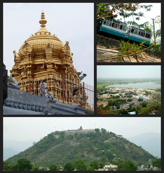
Aruppukottai is a town and a municipality in Virudhunagar district in the state of Tamil Nadu, India. Aruppukottai's classical name is "Sengattu Aravakotai". Aruppukottai is about 50 km from Madurai. It is in the middle of Madurai-Tuticorin National Highways NH-38. The villages and towns surrounding Aruppukottai makes this as a major town as well as a major transit hub and they are also famous for production of jasmine. Aruppukottai is always famous for producing yarn. Sri Ramana Maharishi was born in Tiruchuli near Aruppukottai town. Aruppukottai was part of king Sethupathi of Ramnad. King Sethupathi has Zamin Palace in Palyampatti. As of 2011, the town had a population of 87,722. The town also hosts two famous temples – Arulmigu Meenakshi Chokkanatha Swamy Temple built in 13th century by Pandiya King Maravarma Sundarapandiyan and Seenivasa Perumal Temple Built on the top of Malai arasan Hill.

Omalur is a panchayat town and headquarters of Omalur taluk in the Salem District in the Indian state of Tamil Nadu. It is situated on the National Highway 7 between 11° 73333" latitude and 78° 06667" longitude. It has a population of about 13,600. Agriculture, leather and handloom textiles are the major businesses.

Virudhunagar is a city and the administrative headquarter of the Virudhunagar district in the Indian state of Tamil Nadu. It is located 506 km (314 mi) southwest of the state capital Chennai and 53 km (33 mi) south of Madurai. Virudhunagar emerged as an important trade centre during the British rule. Located to the east of Kowsika River, Virudhunagar has an average elevation of 102 m (335 ft) above sea level and is largely flat with no major geological formations. The town has a humid climate and receives 780 mm (31 in) rainfall annually. It has been ruled at various times by Later Pandyas, Vijayanagar Empire, Madurai Nayaks, Chanda Sahib, Carnatic kingdom and the British. It was formerly known as Virudhupatti.

Madurai district is one of the 38 districts of the state of Tamil Nadu in southeastern India. The city of Madurai serves as the district headquarters. It houses the famous Sri Meenakshi Sundareshwarar temple and is situated on the banks of the river Vaigai. Thiruparankundram is one of the major tourist place in the district. As of 2011, the district had a population of 3,038,252 with a sex-ratio of 990 females for every 1,000 males. Aside from the city of Madurai, the larger towns are Melur, Vadipatti, Thirumangalam, Thirupparankundram, Peraiyur, and Usilampatti. It is an important hub for various film shootings. Alanganallur is a popular spot in the district for Jallikattu, as are Palamedu and Avaniyapuram.
Palani (Tamil:[paɻani], is a town and a taluk headquarters in Dindigul district of the western part of Tamil Nadu state in India. It is located about 106 kilometres south-east of Coimbatore and 122 kilometres north-west of Madurai, 67 kilometres from Kodaikanal. The Palani Murugan Temple or Arulmigu Dhandayuthapani Swamy Temple, dedicated to Murugan is situated on a hill overlooking the town. The temple is visited by more than 7 million pilgrims each year. As of 2011, the town had a population of 70,467 and the Taluk had a population of 292,301 which makes it the second largest town in the district after Dindigul.
Devakottai is a first-grade municipality in the state of Tamil Nadu, India. Located in the Sivaganga district, the town is situated close to the Karaikudi, near Rameswaram National Highway Road (NH-210). It is one of the major cities comes under the Chettinad area with rich heritage of houses built with limestone called "Karai Veedu". This Region is one of the towns in Chettinad belt. The town is famous for its ancient temple Sri Meenakshi Sundareswarar temple also known as Nagara Sivan Kovil.

Rayavaram is a village Panchayat in Pudukkottai district in Tamil Nadu, India.

Melur is the Northern entrance of Madurai district. It is the town and municipality in the Madurai North in the Indian state of Tamil Nadu. Melur Old Name is Called Naduvi Nadu. The name Melur name comes from "Mela Nadu". Melur is called Thaigramam. It is the biggest taluk within the Madurai District. As of 2011, the town had a population of 40,017. Melur is an agricultural land in Madurai and the climate around the area is tropical.

Tiruchirappalli District is one of the 38 districts, located along the Kaveri River, in Tamil Nadu, India. The headquarters of the district is the city of Tiruchirappalli.

Tiruttani is a town in the Tiruvallur district, a suburb of Chennai within the Chennai Metropolitan Area, located in the state of Tamil Nadu, India. The town is renowned for the Tiruttani Murugan Temple, which is one of the Arupadaiveedu and is dedicated to Kartikeya (Murugan). Tiruttani was added to the Chennai Metropolitan Area in October 2022.
Tiruchengode is a selection grade municipality located in western part of southern Indian state of Tamil Nadu. It is famous for the ancient hilltop Ardhanareeswarar Temple, dedicated to the unique combined male-female form of Lord Shiva and Goddess Parvathi. This important place of pilgrimage is mentioned in the Tamil work Silapathikaram as 'Nedulkundru' and is celebrated in the hymns of Saivite saints. The equally famous Chenkottu Velavar Temple, dedicated to Lord Murugan, is situated on the same hill. As of 2011, the town had a population of 95,335. As per 2011 population, Tiruchengode is the largest city in Namakkal district. It is also famous for rig business.

Theni District is one of the 38 districts of Tamil Nadu state in India. Well protected by the scenic hill locks, the district is located besides Madurai district. The town of Theni is the district headquarters. The district is divided into two natural divisions: The hilly areas are constituted by parts of the five taluk's Theni, Bodinayakanur, Periyakulam, Uthamapalayam and Andipatti with thick vegetation and perennial streams from the hills on the western side and Cumbum valley which lies in Uthamapalayam taluk. As of 2011, Theni district had a population of 1,245,899 with a sex ratio of 980 females for every 1,000 males.
Anakaputhur is a neighborhood in the city of Tambaram, situated within the Chennai Metropolitan Area, Tamil Nadu, India.
Cumbum, natively spelt as Kambam, is a town and municipality in Theni district, an Indian state of Tamil Nadu.

Kulithalai is a municipality in Karur district & Sub-urb of Tiruchirapalli City in the Indian state of Tamil Nadu. The recorded history of Kulithalai is known from Cheras, followed by medieval Chola period of the 9th century and has been ruled, at different times, by the Medieval Cholas, Later Cholas, Later Pandyas, Vijayanagar Empire and the British.

Manamadurai is a Municipality Town in Sivaganga district in the Indian state of Tamil Nadu. Manamadurai falls under Manamadurai Legislative assembly.

Manapparai is a municipality in Tiruchirappalli district in the Indian state of Tamil Nadu. Manapparai Town is located 38 km from Trichy. Manapparai is the headquarters of the Manapparai Taluk. Manapparai is famous for murukku and cattle market. As of 2011, the town had a population of 40,510.

Thenthiruperai is a panchayat town in Thoothukudi district in the Indian state of Tamil Nadu. It is located at a distance of 11 km from Tiruvaikuntam, 21 km from Thiruchendur, 30 km from Thoothukudi, 31 km from Tirunelveli and 187 km from Madurai. The village hosts one of the nine temple shrines that constitutes Nava Tirupathi temples. It is also hosts one of the Navakailasams, Then Thiruperai Sri Kailasanathar Temple, the seventh in the series.
Venkatachalapuram is a small village situated in Theni District, Tamil Nadu, India and with direct road connectivity to Theni and Odaipatti. The district headquarters, Theni, is situated 11 kilometres (6.8 mi) north of this village.
Madagondapalli is a village situated in the Denkanikottai taluk of Krishnagiri district in the southern Indian state of Tamil Nadu. Governed by the Madagondapalli Gram Panchayat, the village falls within the administrative of the Thally Block. Positioned approximately 16 kilometers away from Madagondapalli, the nearest town is Hosur.
