Related Research Articles
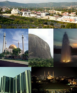
Abuja is the capital and eighth most populous city of Nigeria. Situated at the centre of the country within the Federal Capital Territory (FCT), it is a planned city built mainly in the 1980s based on a master plan by International Planning Associates (IPA), a consortium of three American planning and architecture firms made up of Wallace, Roberts, McHarg & Todd as the lead, Archisystems International, and Planning Research Corporation. The Central Business District of Abuja was designed by Japanese architect Kenzo Tange. It replaced Lagos, the country's most populous city, as the capital on 12 December 1991.

Victoria Island (VI) is an affluent area that encompasses a former island of the same name neighbouring Lagos Island, Ikoyi and the Lekki Peninsula by the Lagos Lagoon. It is the main business and financial centre of Lagos State, Nigeria. Victoria Island is one of the most exclusive and expensive areas to reside in Lagos. The town and island lie within the boundaries of the Eti-Osa Local Government Area (LGA).

Nasarawa State is a state in the North Central region of Nigeria, bordered to the east by the states of Taraba and Plateau, to the north by Kaduna State, to the south by the states of Kogi and Benue, and to the west by the Federal Capital Territory. Named for the historic Nasarawa Emirate, the state was formed from the west of Plateau State on 1 October 1996. The state has thirteen local government areas and its capital is Lafia, located in the east of the state, while a key economic centre of the state is the Karu Urban Area—suburbs of Abuja—along the western border with the FCT.

Aso Rock is a large outcrop of granitic rock located on the outskirts of Abuja, the capital of Nigeria. The Aso Rock is a 400-metre (1,300 ft) prominent monolith with a peak height of 936-metre (3,071 ft) above sea level. It is one of the city's most noticeable features. The Nigerian Presidential Complex, Nigerian National Assembly, and Nigerian Supreme Court are located around it. Much of the city extends to the south of the rock. "Aso" means victorious in the native language of the Asokoro ethnic group.
The Gbagyi or Gbari are an ethnic group found predominantly in Central Nigeria, with an estimated population figure put at 5.8 million, spread in four States, including the FCT, and located in thirty local Government areas, according to the 2006 National Population Census figures. It is also the name of their language. Members of the ethnic group speak two dialects. While speakers of the dialects were loosely called Gwari by both the Hausa Fulani and Europeans during pre-colonial Nigeria they prefer to be known as Gbagyi/Gbari. They live in the Niger, the Federal Capital Territory - Abuja, and Kaduna State. They are also found in Nasarawa central Nigeria Area. Gbagyi/Gbari is one of the most populated ethnic groups in the middle belt and indigenous in the Federal Capital Territory of Nigeria. This means Gbagyi people are the bonafide owners of the Nigerian capital city, Abuja.
Ode-Omu is a town in the present Osun State, Nigeria, established in 1900 sequel to implementation of relocation treaty signed between the Ibadan (Oyo) and Ife in 1886. This place is situated in Ayedaade, Osun, Nigeria, its geographical coordinates are 7° 32' 0" North, 4° 24' 0" East and its original name is Ode-Omu. The settlement was established following civil unrest in neighbouring Yoruba cities of Ife and Modakeke in south-western Nigeria. Most of the families in Ode-Omu have links to Modakeke.

Ilorin International Airport is an airport serving Ilorin, a city in Kwara State of Nigeria.Ilorin International Airport Owned and operated by Federal Airports Authority of Nigeria (FAAN) is located about 1.8 kilometers from downtown Ilorin. The airport has one runway, which is 3,100M X 60M, an approach of 121.2MHz
New Karu is the headquarters of Karu Local Government Area, Nasarawa State. It is one of the largest towns that make up the greater Karu urban centre in Nasarawa state which is a conurbation consisting of towns and villages along the Keffi-Abuja expressway making up the Nyanya-Masaka urban centre. The major towns that make up this urban area are;
Gwandara is a West Chadic language, and the closest relative of Hausa. Its several dialects are spoken in northern Nigeria, predominantly in the north central region of Nigeria by the Gwandara people and some settlers who are about 30,000 people. They are found in large numbers in Abuja, Niger, Kaduna, Kogi and a resettlement town of New Karshi, Karu LGA, Nasarawa State. New Karshi has a Gwandara first class emir Muhammadu Bako III (PhD).

Aboh Mbaise is a Local Government Area of Imo State, Nigeria. Its headquarters is in the town of Aboh.
Sanga is a Local Government Area in southern Kaduna State, Nigeria. Its headquarters is in the town of Gbantu. The Local Government Council is chaired by Bisallah Malam. It has an area of 1,821 km2 and had a population of 151,485 as at the 2006 census. The postal code of the area is 801.
Karu is a Local Government Area in Nasarawa State, central Nigeria. It is close in proximity to the Federal Capital Territory of Nigeria. It has an area of 2,640 km2. Karu local government has its headquarters in New Karu town. It was originally built to house the capital's civil servants and lower income families, but had no running water or good sanitation system. Karu has grown in population beyond its original planned capacity. Ensure Administrative convenience and bring government closer to the grass root people, Karshi Development Area was created with its administrative secretariat at Uke.
Masaka is a town in Nasarawa, central Nigeria. It is a district of Karu Local Government Area, Nasarawa State and is among the towns that forms the Karu urban area, a conurbation of towns under Karu Local Government Area of Nasarawa State. The neighbouring towns to Masaka, also in this urban area as a result of their merger following a population explosion in the zone, are:

Ado is a town in Nasarawa, central Nigeria. It is a district of Karu Local Government Area, Nasarawa State and is among the towns that make up the Karu urban area, a conurbation of towns stretching to Nigeria's Federal Capital Territory.
Mararaba is a town in Nasarawa State, central Nigeria. It is a district of Karu Local Government Area, Nasarawa State and is among the towns that make up the Karu urban area, a conurbation of towns stretching to Nigeria's Federal Capital Territory. Its neighbouring towns are:
New Nyanya is a town in Nasarawa State. It is a district of Karu Local Government Area, Nasarawa State, and is among the towns that make up the Karu Urban Area, a conurbation of towns stretching into the Federal Capital Territory (FCT). New Nyanya is loosely considered as part of the metropolitan area of Abuja.
Philips Tanimu Aduda is a Nigerian politician. He served two terms in the Nigerian House of Representatives between 2003 and 2011, and was elected to the Senate for the Abuja Federal Capital Territory in the 9 April 2011 elections, running on the People's Democratic Party (PDP) ticket.
The Karu Urban Area is an urban area in central Nigeria. The urban area is majorly located in the Nigerian state of Nasarawa, but with some parts stretching into the boundaries of the Federal Capital Territory (FCT). It has an area of 40,000 hectares (400 km2) and a population of some 2 million.
Gade (Gede) is a Nupoid language of Nigeria. Glottolog 4.7 (2022) classifies it as an independent branch of Benue-Congo rather than as a Nupoid language.

New Karshi is a town in Karu Local Government Area of Nasarawa State, Nigeria, founded in the 1980s by Muhammadu Bako II. It is a semi-autonomous local government created out of Karu LGA as Karshi Development area with the administrative secretariat in Uke. Karshi has a local government chairman as its administrative head and a seat in the Nasarawa State House of Assembly. Emir of Karshi Emirate, Alhaji (Dr) Muhammadu Sani Bako III, a first class chief is the traditional head of New Karshi. It has a population of about 30,000 people. The predominant tribes are Gwandara, Gbagyi, Gade, Bassa and Hausa.
References
- ↑ (PDF) https://web.archive.org/web/20081120203201/http://www.isted.com/villes-developpement/cities_alliance/karu.pdf. Archived from the original (PDF) on November 20, 2008. Retrieved October 26, 2010.
{{cite web}}: Missing or empty|title=(help)