Kuruwita

Last updated
Kuruwita
කුරුවිට
Town
Sri Lanka location map.svg
Red pog.svg
Kuruwita
Coordinates: 6°49′18″N80°21′41″E / 6.8218°N 80.3615°E / 6.8218; 80.3615
Country Sri Lanka
Province Sabaragamuwa Province
District Ratnapura District
Time zone Sri Lanka Standard Time (UTC+5:30)

Kuruwita is a town in the Ratnapura District of Sabaragamuwa Province of Sri Lanka. It is 87 km from Colombo. It used to be served by the 2 ft 6 in (762 mm) narrow gauge Sabaragamuwa Railway, a branch of the national railway system. And known for the nearby waterfall called Bopath Ella.

Town settlement that is bigger than a village but smaller than a city


A town is a human settlement. Towns are generally larger than villages but smaller than cities, though the criteria to distinguish them vary considerably between different parts of the world.

Ratnapura District Administrative District in Sabaragamuwa Province, Sri Lanka

Ratnapura is a district of Sri Lanka in the Sabaragamuwa Province.

Sabaragamuwa Province Province in Sri Lanka

The Sabaragamuwa Province, is one of the nine provinces of Sri Lanka, the first level administrative division of the country. The provinces have existed since the 19th century but did not have any legal status until 1987 when the 13th Amendment to the Constitution of Sri Lanka established provincial councils. The Sabaragamuwa Province contains two districts: Ratnapura and Kegalle. It is named after its former indigenous inhabitants, namely the Sabara, an indic term for hunter-gatherer tribes, a term seldom used in ancient Sri Lanka. Sabaragamuwa University is in Belihuloya.

Contents

Tourist attractions

Bopath Ella Bopath Ella Falls - panoramio.jpg
Bopath Ella
Delgamuwa Raja Maha Vihara

Delgamuwa Raja Maha Vihara is an ancient Buddhist temple situated in Kuruvita of Ratnapura District, Sri Lanka. This temple is reputed as the hiding place of the tooth relic of Buddha during the ruling period of Portuguese in the country.

Relic of the tooth of the Buddha

The Sacred Relic of the tooth of Buddha is venerated in Sri Lanka as a cetiya "relic" of Gautama Buddha, on whose teachings Buddhism was founded.

Portuguese Empire global empire centered in Portugal

The Portuguese Empire, also known as the Portuguese Overseas or the Portuguese Colonial Empire, was one of the largest and longest-lived empires in world history. It existed for almost six centuries, from the capture of Ceuta in 1415, to the handover of Portuguese Macau to China in 1999. The empire began in the 15th century, and from the early 16th century it stretched across the globe, with bases in North and South America, Africa, and various regions of Asia and Oceania. The Portuguese Empire has been described as the first global empire in history, a description also given to the Spanish Empire.

See also

Balangoda Man refers to hominins from Sri Lanka's late Quaternary period. The term was initially coined to refer to anatomically modern Homo sapiens from sites near Balangoda that were responsible for the island's Mesolithic 'Balangoda Culture'. The earliest evidence of Balangoda Man from archaeological sequences at caves and other sites dates back to 38,000 BP, and from excavated skeletal remains to 30,000 BP, which is also the earliest reliably dated record of anatomically modern humans in South Asia. Cultural remains discovered alongside the skeletal fragments include geometric microliths dating to 28,500 BP, which together with some sites in Africa is the earliest record of such stone tools.

Batadombalena Archaeological site in Sri Lanka

Batadombalena is an archaeological site with evidence of habitation from 8,000 years BCE, Balangoda Man, located 85 km (52.8 mi) from Colombo in Sri Lanka, a two-hour drive from Colombo.

Related Research Articles

Badulla City in Sri Lanka

Badulla is the main city of Uva Province situated in the lower central hills of Sri Lanka. It is the capital city of Uva Province and the Badulla District.

Pinnawala Town in Sabaragamuwa Province

Pinnawala is a village in Kegalle District of Sri Lanka and is around 90 km from the capital, Colombo. It is well known for its elephant orphanage.

Batatotalena Cave cave in Sri Lanka

The Batatotalena Cave, also known as the Diva Guhava in Buddhist literature, is a cave system in Sudagala, 8 km (5 mi) away from the town of Kuruwita, in the Sabaragamuwa Province of Sri Lanka.

Bopath Ella Falls waterfall

Bopath Ella is a waterfall situated in the Ratnapura District of Sri Lanka. It has a shape very similar to the leaf of the Sacred fig or "Bo" tree, which has earned it this name. The waterfall is a major tourist attraction in the country. Local myths say that it is haunted and that it hides a treasure trove.

Avissawella Town in Western Province, Sri Lanka

Avissawella, is a township in Sri Lanka, governed by an Urban Council, situated on the A4 route from Colombo to Ratnapura, Colombo District, Western Province, Sri Lanka, approximately 59 km east of capital Colombo. It is also known as Seethawakapura.

Embilipitiya Town in Sabaragamuwa Province, Sri Lanka

Embilipitiya is a town, governed by an urban council, in Ratnapura District, Sabaragamuwa Province, Sri Lanka.

Saman (deity)

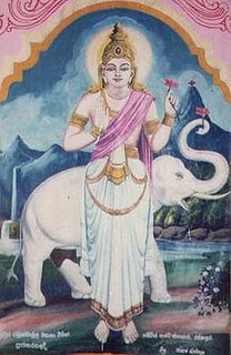
Saman is a deity, subject to local and indigenous belief and worship in Sri Lanka. The name Saman means "the rising morning sun". His character is of historical significance for the Sinhalese people and veneration especially to all the Buddhists. God Maha Sumana Saman is depicted crowned, bejeweled, holding a lotus flower in his right or left hand and accompanied by a white elephant.

Beragala Town in Sri Lanka

Beragala is a small town in Sri Lanka. It is located in Badulla District of Uva Province, Sri Lanka. It is located 183 km away from Colombo along the A4 Highway. The area is known for its natural environment, as well as for landslides.

Adams Peak Mountain in the central highlands of Sri Lanka.

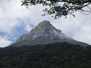
Adam's Peak is a 2,243 m (7,359 ft) tall conical mountain located in central Sri Lanka. It is well known for the Sri Pada, i.e., "sacred footprint", a 1.8 m rock formation near the summit, which in Buddhist tradition is held to be the footprint of the Buddha, in Hindu tradition that of Shiva and in Islamic and Christian tradition that of Adam, or that of St. Thomas.

A4 highway (Sri Lanka) road in Sri Lanka

The A4 Highway is the longest highway in Sri Lanka, at 430 kilometres (270 mi) in length. It connects Colombo with Batticaloa, through a large number of important cities in Western, Sabaragamuwa, Uva and Eastern provinces.

'Mangalagama' is an ancient village in Sri Lanka. It is located within the Rambukkana Division in the Kegalle District in Sabaragamuwa Province, Sri Lanka. Managlagama is situated by the Colombo - Kandy main road, 87 km away from Colombo / 28 km away from Kandy. The nearest towns are: Kegalla (6 km) and Mawanella (4 km). The post office that covers Managlagama is: Molagoda (2 km).

The Pelmadulla Divisional Secretariat is a divisional secretariat in the Ratnapura District of the Sabaragamuwa Province of Sri Lanka.

Ella, Sri Lanka Place in Uva Province, Sri Lanka

Ella is a small town in the Badulla District of Uva Province, Sri Lanka governed by an Urban Council. It is approximately 200 kilometres (120 mi) east of Colombo and is situated at an elevation of 1,041 metres (3,415 ft) above sea level. The area has a rich bio-diversity, dense with numerous varieties of flora and fauna. Ella is surrounded by hills covered with cloud forests and tea plantations. The town has a cooler climate than surrounding lowlands, due to its elevation. The Ella Gap allows views across the southern plains of Sri Lanka.

Maha Saman Devalaya

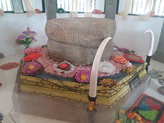
Maha Saman Devalaya or the Great Saman Temple is a shrine dedicated to deity Saman, situated at Ratnapura, Sri Lanka who is the presiding deity of the Sri Pada Mountain which is also called Samanthakuta meaning the mountain of Saman which is believed to have the left foot impression of Lord Buddha which he kept in his visit to Sri Lanka.

Eheliyagoda Town in Sabaragamuwa, Sri Lanka

Eheliyagoda is a town in Ratnapura District, Sabaragamuwa Province, Sri Lanka. It is located approximately 47 km (29 mi) east of Colombo.

References

    Coordinates: 06°46′N80°22′E / 6.767°N 80.367°E / 6.767; 80.367

    Geographic coordinate system Coordinate system

    A geographic coordinate system is a coordinate system that enables every location on Earth to be specified by a set of numbers, letters or symbols. The coordinates are often chosen such that one of the numbers represents a vertical position and two or three of the numbers represent a horizontal position; alternatively, a geographic position may be expressed in a combined three-dimensional Cartesian vector. A common choice of coordinates is latitude, longitude and elevation. To specify a location on a plane requires a map projection.