Korytów is a village in the administrative district of Gmina Gaworzyce, within Polkowice County, Lower Silesian Voivodeship, in south-western Poland. Prior to 1945 it was in Germany.

Jutrzyna is a village in the administrative district of Gmina Wiązów, within Strzelin County, Lower Silesian Voivodeship, in south-western Poland. Prior to 1945 it was in Germany.
Żabiniec is a village in the administrative district of Gmina Topólka, within Radziejów County, Kuyavian-Pomeranian Voivodeship, in north-central Poland. It lies approximately 8 kilometres (5 mi) south-west of Topólka, 20 km (12 mi) south-east of Radziejów, and 62 km (39 mi) south of Toruń.
Skoraczewiec is a village in the administrative district of Gmina Sośno, within Sępólno County, Kuyavian-Pomeranian Voivodeship, in north-central Poland. It lies approximately 9 kilometres (6 mi) south-west of Sośno, 16 km (10 mi) south-east of Sępólno Krajeńskie, and 34 km (21 mi) north-west of Bydgoszcz.
Bukowa Góra is a village in the administrative district of Gmina Wałcz, within Wałcz County, West Pomeranian Voivodeship, in north-western Poland. It lies approximately 12 kilometres (7 mi) east of Wałcz and 138 km (86 mi) east of the regional capital Szczecin.
Czerniczyn is a village in the administrative district of Gmina Hrubieszów, within Hrubieszów County, Lublin Voivodeship, in eastern Poland, close to the border with Ukraine. It lies approximately 7 kilometres (4 mi) south of Hrubieszów and 109 km (68 mi) south-east of the regional capital Lublin.
Brzeg is a village in the administrative district of Gmina Pęczniew, within Poddębice County, Łódź Voivodeship, in central Poland. It lies approximately 7 kilometres (4 mi) south-west of Pęczniew, 26 km (16 mi) south-west of Poddębice, and 55 km (34 mi) west of the regional capital Łódź.
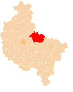
Rokitnica is a village in the administrative district of Gmina Stryków, within Zgierz County, Łódź Voivodeship, in central Poland. It lies approximately 2 kilometres (1 mi) north-east of Stryków, 17 km (11 mi) north-east of Zgierz, and 19 km (12 mi) north-east of the regional capital Łódź.
Chełm is a village in the administrative district of Gmina Wolbrom, within Olkusz County, Lesser Poland Voivodeship, in southern Poland. It lies approximately 5 kilometres (3 mi) south of Wolbrom, 16 km (10 mi) north-east of Olkusz, and 36 km (22 mi) north of the regional capital Kraków.
Borek Klimontowski is a village in the administrative district of Gmina Klimontów, within Sandomierz County, Świętokrzyskie Voivodeship, in south-central Poland. It lies approximately 3 kilometres (2 mi) south of Klimontów, 22 km (14 mi) west of Sandomierz, and 66 km (41 mi) south-east of the regional capital Kielce.
Wola Błędowska is a village in the administrative district of Gmina Pomiechówek, within Nowy Dwór Mazowiecki County, Masovian Voivodeship, in east-central Poland. It lies approximately 10 kilometres (6 mi) north-west of Brody-Parcele, 12 km (7 mi) north of Nowy Dwór Mazowiecki, and 43 km (27 mi) north-west of Warsaw.
Złotki-Przeczki is a village in the administrative district of Gmina Boguty-Pianki, within Ostrów Mazowiecka County, Masovian Voivodeship, in east-central Poland. It lies approximately 3 kilometres (2 mi) north-east of Boguty-Pianki, 37 km (23 mi) east of Ostrów Mazowiecka, and 115 km (71 mi) north-east of Warsaw.
Staw II is a village in the administrative district of Gmina Strzałkowo, within Słupca County, Greater Poland Voivodeship, in west-central Poland. It lies approximately 5 kilometres (3 mi) north-west of Strzałkowo, 9 km (6 mi) north-west of Słupca, and 58 km (36 mi) east of the regional capital Poznań.
Grabówka is a settlement in the administrative district of Gmina Namysłów, within Namysłów County, Opole Voivodeship, in south-western Poland. It lies approximately 4 kilometres (2 mi) north-east of Namysłów and 49 km (30 mi) north of the regional capital Opole.
Grodziec is a village in the administrative district of Gmina Niemodlin, within Opole County, Opole Voivodeship, in south-western Poland.
Strzeszewo is a village in the administrative district of Gmina Wicko, within Lębork County, Pomeranian Voivodeship, in northern Poland. It lies approximately 10 kilometres (6 mi) north-east of Wicko, 18 km (11 mi) north of Lębork, and 69 km (43 mi) north-west of the regional capital Gdańsk.
Łęguty is a village in the administrative district of Gmina Gietrzwałd, within Olsztyn County, Warmian-Masurian Voivodeship, in northern Poland. It lies approximately 5 kilometres (3 mi) west of Gietrzwałd and 23 km (14 mi) west of the regional capital Olsztyn.
Łazy is a settlement in the administrative district of Gmina Dębno, within Myślibórz County, West Pomeranian Voivodeship, in north-western Poland. It lies approximately 5 kilometres (3 mi) north-east of Dębno, 22 km (14 mi) south of Myślibórz, and 75 km (47 mi) south of the regional capital Szczecin.
Warszkówko is a village in the administrative district of Gmina Sławno, within Sławno County, West Pomeranian Voivodeship, in north-western Poland. It lies approximately 5 kilometres (3 mi) east of Sławno and 178 km (111 mi) north-east of the regional capital Szczecin.
Pustowo is a village in the administrative district of Gmina Sławoborze, within Świdwin County, West Pomeranian Voivodeship, in north-western Poland.