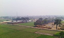
Ghazipur, is a city in the state of Uttar Pradesh, India. Ghazipur city is the administrative headquarters of the Ghazipur district, one of the four districts that form the Varanasi division of Uttar Pradesh. It is located on the Ganges (Ganga) River near the border with Bihar state, about 40 miles (65 km) northeast of Varanasi (Benares).The city of Ghazipur also constitutes one of the seven distinct tehsils, or subdivisions, of the Ghazipur district.

Ghazipur district is a district of Uttar Pradesh state in northern India. The city of Ghazipur is the district headquarters. The district is part of Varanasi Division. The region of Ghazipur is famous mainly for the production of its unique rose-scented Spray called Gulab Jal, and for the tomb of the Governor General of British India, Lord Cornwallis, who died here. His tomb is situated in Western part of City, and is conserved by Archaeological Survey of India.

Dildarnagar Fatehpur Bazar is a neighbourhood of Dildarnagar, located in the Ghazipur district of the Indian state of Uttar Pradesh. It is situated on the banks of the River Ganges and is approximately 35 kilometers from the city of Ghazipur. The town is known for its historical and cultural significance, and it has several temples, mosques, and other landmarks that attract visitors from different parts of India. Dildarnagar is also an important commercial center and has a bustling market where locals and visitors can purchase a variety of goods and products. As of 2011 estimate the Population of Dildarnagar is 12855 and have an area of 1000 hectares.
Hisua is a city and a municipality in Nawada district in the India state of Bihar. It is situated on the right bank of the Tilaiya river along Gaya and Nawada road, 9 miles (14 km) west of Nawada and 27 miles (43 km) east of Gaya. The city lies adjacent to the Tilaiya Junction railway station on the Southern Bihar Railway. The primary occupation of Hisua's residents is agriculture, and the town is known for its pottery and local poetry. Hisua is also known for gold jewellery shops. Tilkut, lai, anarsa and khaja are among the traditional sweets from Hisua that are popular in Bihar.
Zamania is a town in the Indian state of Uttar Pradesh. Its municipal council is subordinate to the Ghazipur District. It is also the administrative head of Zamania tehsil,. It is also a very historical town, it derives its name from Ali Quli Khan Zaman, who was also known as Khan Zaman or Zaman Khan, he was a governor of Jaunpur, and Ghazipur during the time of Akbar.
Bahadurganj is a Municipality located in Zahurabad pargama of the Kasimabad Tehsil in Ghazipur district of Uttar Pradesh, India. Bahadurganj is located one the banks of Tamsa and Bhainsahi rivers.The town also served as the capital of Qasimabad estate.
Dildarnagar Kamsar is a pargana (region) and a mashra comprising 34 settlements located around the Karamnasa River in the Ghazipur district of Uttar Pradesh and the Kaimur district of Bihar, India. Of these, 18 mouzas are the primary settlements. It is a prominent settlement of Khanzadas, also known as Kamsari Pathans, as well as Afghan Pathans, primarily of the Niazi and Yusufzai clans. The original name of the region was Kamsar, but due to close and historical ties with the family of Bara Pathans, the region is often referred to as Kamsar-O-Bar. It was established in 1542 by Raja Narhar Khan.
Amir Chak is a village in Kamsaar in the Indian state of Uttar Pradesh.

Gorasara is a village located in Dildarnagar Kamsar, Uttar Pradesh, India. Goarasara village was established by Bhikham Khan, son of Fateh Bahadur Khan, and great great grand son of Narhar Khan.

Saraila is a village in Kamsaar in the Indian state of Uttar Pradesh.Saraila is a village in Seorai Tehsil in Ghazipur District of Uttar Pradesh, India. It belongs to Varanasi Division. It is located 30 km to the south of District headquarters Ghazipur. 11 km from Seorai. 372 km from State capital Lucknow. The village was also a part of Daudpur Estate which had its capital at Dewaitha during Mughal and early British era.

Bara is a village of Dildarnagar Kamsar in Ghazipur district in the Indian state of Uttar Pradesh. It is situated on the banks of the holy river Ganges.
Chitarkoni is a village in Kamsaar in the Indian state of Uttar Pradesh.

Jaburna is a village in Kamsaar in the Indian state of Uttar Pradesh.
Fufuao or Rampur Phuphuaon is a village in Dildarnagar Kamsar in the Indian state of Uttar Pradesh.
Khardiha is a village in the Karail area of the Mohammadabad tehsil in Ghazipur district, Uttar Pradesh, India. It has population of 1896 as per 2011 Census. It has its own local administration under Panchayati Raj system, with Gram Pradhan as head of local administration. Since the very beginning this village has been an important center of education and cultural activities.
Umar Ganj is a village in Zamania tehsil of Ghazipur District, Uttar Pradesh, India. As of the 2011 Census Umar Ganj has a total population of 7816 and a geographical area of 536.56 hectares. Umar ganj history was a market area established by the local zamindars and banias. It was a seat of zamindari of Umarganj urf Khizirpur. Or also known as Khizri shaheed.
Zahurabad is a village and a block in Kasimabad, Ghazipur tehsil of Ghazipur District, Uttar Pradesh, India. Jahurabad also gives its name to the Jahurabad Assembly Constituency. Jahurabad was a Jagir and was ruled by the family of Nawab Sheikh Abdullah, the family of Jahurabad, Bahadurganj and Qasimabad. As per 1901 Census of India Jahurabad pargana had a total population of 69589 and was spread over 79868 acres.
Mednipur is the largest village by area in Zamania tehsil of Ghazipur District, Uttar Pradesh, India. There are two more villages along, one Kalupr and second Tari or Tarighat. All three are separate panchayats.
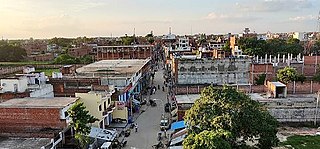
Dildarnagar is a municipality in Kamsaar of Ghazipur District, Uttar Pradesh, India. Dildarnagar is a fast-developing town. It is located 34 km from Ghazipur. It is also known as the heart of the Kamsaar-o-Bar region. The total area of Dildarnagar includes Fatehpur Bazar, Dildarnagar Gao, Tajpur, and Nirahukapura. These four neighbourhoods form the town of Dildarnagar. As of the 2011 census, the population of Dildarnagar was 28,913 and the town had an area of 1,995.95 hectares. Dildarnagar is on the road from Varanasi to Buxar. It was also the capital of Dildarnagar Estate.
Dewaitha is a village of Dildarnagar Kamsar,in Zamania tehsil of Ghazipur, India, located on the banks of the Karmanasa River and it's tributary Eknaiya, The village had a population of 7,104 as of the 2011 Census of India. The place is inhabited by Kamsar Pathans..