
The Amu Darya is a major river in Central Asia and Afghanistan. Rising in the Pamir Mountains, north of the Hindu Kush, the Amu Darya is formed by the confluence of the Vakhsh and Panj rivers, in the Tigrovaya Balka Nature Reserve on the border between Afghanistan and Tajikistan, and flows from there north-westwards into the southern remnants of the Aral Sea. In its upper course, the river forms part of Afghanistan's northern border with Tajikistan, Uzbekistan, and Turkmenistan. In ancient history, the river was regarded as the boundary of Greater Iran with "Turan", which roughly corresponded to present-day Central Asia.

The Hindu Kush is an 800-kilometre-long (500 mi) mountain range in Central and South Asia to the west of the Himalayas. It stretches from central and western Afghanistan into northwestern Pakistan and far southeastern Tajikistan. The range forms the western section of the Hindu Kush Himalayan Region (HKH); to the north, near its northeastern end, the Hindu Kush buttresses the Pamir Mountains near the point where the borders of China, Pakistan and Afghanistan meet, after which it runs southwest through Pakistan and into Afghanistan near their border. The eastern end of the Hindu Kush in the north merges with the Karakoram Range. Towards its southern end, it connects with the Spin Ghar Range near the Kabul River. It divides the valley of the Amu Darya to the north from the Indus River valley to the south. The range has numerous high snow-capped peaks, with the highest point being Tirich Mir or Terichmir at 7,708 metres (25,289 ft) in the Chitral District of Khyber Pakhtunkhwa, Pakistan.

The Syr Darya, historically known as the Jaxartes, is a river in Central Asia. The name, a borrowing from the Persian language, literally means Syr Sea or Syr River, and sometimes it is referred to in this way. It originates in the Tian Shan Mountains in Kyrgyzstan and eastern Uzbekistan and flows for 2,256.25 kilometres (1,401.97 mi) west and north-west through Uzbekistan and southern Kazakhstan to the northern remnants of the Aral Sea. It is the northern and eastern of the two main rivers in the endorheic basin of the Aral Sea, the other being the Amu Darya (Jayhun).

Sogdia or Sogdiana was an ancient Iranian civilization in present-day Uzbekistan, Tajikistan, Kazakhstan, and Kyrgyzstan. Sogdiana was also a province of the Achaemenid Empire, and listed on the Behistun Inscription of Darius the Great. Sogdiana was first conquered by Cyrus the Great, the founder of the Achaemenid Empire, and then was annexed by the Macedonian ruler Alexander the Great in 328 BC. It would continue to change hands under the Seleucid Empire, Greco-Bactrian Kingdom, Kushan Empire, Hephthalite Empire, and Sasanian Empire.
The Saka, Śaka, Shaka, Śāka or Sacae were a group of nomadic Iranian peoples who historically inhabited the northern and eastern Eurasian Steppe and the Tarim Basin.
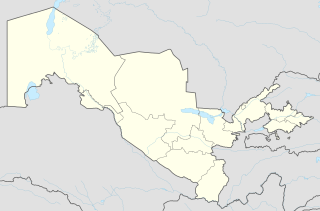
Karakalpakstan, officially the Republic of Karakalpakstan, is an autonomous republic within Uzbekistan. It occupies the whole northwestern end of Uzbekistan. The capital is Nukus. The Republic of Karakalpakstan has an area of 160,000 square kilometres (62,000 sq mi). Its territory covers the classical land of Khwarezm, which in classical Persian literature was known as کات.

The Bactria–Margiana Archaeological Complex or Oxus Civilization, recently dated to c. 2250–1700 BC, is the modern archaeological designation for a Bronze Age civilization of Central Asia, previously dated to c. 2400–1900 BC, by Sandro Salvatori, in its urban phase or Integration Era.

The Tarim Basin is an endorheic basin in Northwest China occupying an area of about 1,020,000 km2 (390,000 sq mi) and one of the largest basins in Northwest China. Located in China's Xinjiang region, it is sometimes used synonymously to refer to the southern half of the province, or Nanjiang, as opposed to the northern half of the province known as Dzungaria or Beijiang. Its northern boundary is the Tian Shan mountain range and its southern boundary is the Kunlun Mountains on the edge of the Tibetan Plateau. The Taklamakan Desert dominates much of the basin. The historical Uyghur name for the Tarim Basin is Altishahr, which means 'six cities' in Uyghur.

Russian Turkestan was the western part of Turkestan within the Russian Empire’s Central Asian territories, and was administered as a Krai or Governor-Generalship. It comprised the oasis region to the south of the Kazakh Steppe, but not the protectorates of the Emirate of Bukhara and the Khanate of Khiva.

The Caspian tiger was a tiger population of the Panthera tigris tigris subspecies that was native to eastern Turkey, northern Iran, Mesopotamia, the Caucasus around the Caspian Sea, Central Asia to northern Afghanistan, the Xinjiang region in western China. Until the Middle Ages, it was also present in Ukraine and southern Russia. It inhabited sparse forests and riverine corridors in this region until the 1970s. This population was regarded as a distinct subspecies and assessed as extinct in 2003.

Termez is the capital of Surxondaryo Region in southern Uzbekistan. It is notable as the site of Alexander the Great's city Alexandria on the Oxus, as a center of Early Buddhism, as a site of Muslim pilgrimage, and as a base of Soviet Union military operations in Afghanistan, accessible via the nearby Hairatan border crossing.
The Karakalpaks or Qaraqalpaqs, are a Turkic ethnic group native to Karakalpakstan in Northwestern Uzbekistan. During the 18th century, they settled in the lower reaches of the Amu Darya and in the (former) delta of Amu Darya on the southern shore of the Aral Sea. The name "Karakalpak" comes from two words: qara meaning "black" and qalpaq meaning "hat". The Karakalpaks number nearly 620,000 worldwide, out of which about 500,000 live in the Uzbek Republic of Karakalpakstan.

The Yarkand River is a river in the Xinjiang Uyghur Autonomous Region of western China. It originates in the Rimo Glacier in a part of the Karakoram range and flows into the Tarim River or Neinejoung River, with which it is sometimes identified. However, in modern times, the Yarkand river drains into the Shangyou Reservoir and exhausts its supply without reaching the Tarim river. The Yarkand River is approximately 1,332.25 km (827.82 mi) in length, with an average discharge of 210 m3/s (7,400 cu ft/s).

Toʻrtkoʻl (Uzbek: Toʻrtkoʻl/Тўрткўл; Karakalpak: Tórtkúl/Төрткүл, also spelled as Turtkul, is a city in Karakalpakstan, Uzbekistan and the administrative center of the Toʻrtkoʻl District.
This article lists historical urban community sizes based on the estimated populations of selected human settlements from 7000 BC – AD 1875, organized by archaeological periods.

Kangju was the Chinese name of a kingdom in Central Asia during the first half of the first millennium CE. The name Kangju is now generally regarded as a variant or mutated form of the name Sogdiana. According to contemporaneous Chinese sources, Kangju was the second most powerful state in Transoxiana, after the Yuezhi. Its people, known in Chinese as the Kāng (康), were evidently of Indo-European origins, spoke an Eastern Iranian language, and had a semi-nomadic way of life. They were probably identical to the Sogdians, or other Iranian groups closely related to them, such as the Asii.
Communities of various religious and ethnic background have lived in the land of what is now Afghanistan. Before the Islamic conquest, south of the Hindu Kush was ruled by the Zunbil and Kabul Shahi rulers. When the Chinese travellers visited Afghanistan between 399 and 751 AD, they mentioned that Buddhism was practiced in different areas between the Amu Darya in the north and the Indus River in the south. The land was ruled by the Kushans followed by the Hephthalites during these visits. It is reported that the Hephthalites were fervent followers of the god Surya.
Gurlen or Gurlan is a town and seat of Gurlen District in Xorazm Region in Uzbekistan. It is located near the border with Turkmenistan in western Uzbekistan, 42 kilometres (26 mi) north-west of Urgench, north of Shovot, and south of the Amu Darya river. Gurlen is a major centre for cotton production, and rice and yams are also significant other crops.
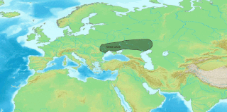
The Muslim conquest of Transoxiana or Arab conquest of Transoxiana were the 7th and 8th century conquests, by Umayyad and Abbasid Arabs, of Transoxiana, the land between the Oxus and Jaxartes rivers, a part of Central Asia that today includes all or parts of Uzbekistan, Tajikistan, Kazakhstan, and Kyrgyzstan.

This is a list of the extreme points of Tajikistan.