Lønsdal

Last updated
Lønsdal
Village
Polarsirkelen Hoyfjellshotell in Lonsdal.jpg
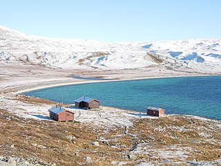
Polarsirkelen Høyfjellshotell in Lønsdal
Norway Nordland location map.svg
Red pog.svg
Lønsdal
Location in Nordland
Norway location map.svg
Red pog.svg
Lønsdal
Lønsdal (Norway)
Coordinates: 66°44′35″N15°27′48″E / 66.7431°N 15.4634°E / 66.7431; 15.4634 Coordinates: 66°44′35″N15°27′48″E / 66.7431°N 15.4634°E / 66.7431; 15.4634
Country Norway
Region Northern Norway
County Nordland
District Salten
Municipality Saltdal
Elevation
[1]
511 m (1,677 ft)
Time zone UTC+01:00 (CET)
  Summer (DST) UTC+02:00 (CEST)
Post Code
8255 Røkland

Lønsdal is a village in the municipality of Saltdal in Nordland county, Norway. The village is located in the Lønsdal valley, along the Lønselva river. European route E06 highway and the Nordland Line both pass through the village. The village also has a train station on the Nordland Line, about halfway between Dunderland Station and Røkland Station.

Saltdal Municipality in Nordland, Norway

Saltdal is a municipality in Nordland county, Norway. It is part of the traditional district of Salten. The administrative centre of the municipality is the village of Rognan. Other villages in Saltdal include Røkland and Lønsdal.

Nordland County (fylke) of Norway

Nordland is a county in Norway in the Northern Norway region, bordering Troms in the north, Trøndelag in the south, Norrbotten County in Sweden to the east, Västerbotten County to the southeast, and the Atlantic Ocean to the west. The county was formerly known as Nordlandene amt. The county administration is in Bodø. The remote Arctic island of Jan Mayen has been administered from Nordland since 1995.

Norway constitutional monarchy in Northern Europe

Norway, officially the Kingdom of Norway, is a Nordic country in Northern Europe whose territory comprises the western and northernmost portion of the Scandinavian Peninsula; the remote island of Jan Mayen and the archipelago of Svalbard are also part of the Kingdom of Norway. The Antarctic Peter I Island and the sub-Antarctic Bouvet Island are dependent territories and thus not considered part of the kingdom. Norway also lays claim to a section of Antarctica known as Queen Maud Land.

View of Lonsdal Station Lonsdal stasjon.jpg
View of Lønsdal Station

The village lies just east of the lake Kjemåvatnet and the mountain Ørfjellet. Due to its proximity to Junkerdal National Park and Saltfjellet–Svartisen National Park, it is mostly a tourist village. There is a hotel and it is a starting point for many hiking tours. [2]

Kjemåvatnet lake in Saltdal, Norway

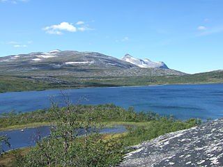
Kjemåvatnet (Norwegian) or Giebbnejávrre (Lule Sami) is a lake that lies in the municipality of Saltdal in Nordland county, Norway. The 2.64-square-kilometre (1.02 sq mi) lake lies about 2 kilometres (1.2 mi) west of the village of Lønsdal.

Junkerdal National Park national park in Norway

Junkerdal National Park is a national park that lies in the municipalities of Saltdal and Fauske in Nordland county, Norway, along the border with Sweden. The 682-square-kilometre (263 sq mi) park was opened in 2004. The park borders the Junkerdalsura nature reserve.

Saltfjellet–Svartisen National Park national park in Nordland, Norway

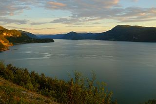
Saltfjellet–Svartisen National Park is a national park in Nordland county in Norway. It is located within the municipalities of Beiarn, Meløy, Rana, Rødøy, Saltdal, and Bodø. European route E06 and the Nordland Line both follow the southern and eastern borders around the park. The park's eastern border is the Norway-Sweden border and a portion of this border is shared with the Vindelfjällen Nature Reserve which lies in Sweden.

Related Research Articles

Rognan Village in Northern Norway, Norway

Rognan is a village and the administrative centre of the municipality of Saltdal in Nordland county, Norway. The village is located at the innermost part of Skjerstad Fjord, called Saltdal Fjord. It is located about 15 kilometres (9.3 mi) north of the village of Røkland.

Balvatnet lake in Saltdal, Nordland, Norway

Balvatnet (Norwegian) or Bállávrre (Lule Sami) is a lake that lies in the municipality of Saltdal in Nordland county, Norway. The 41.46-square-kilometre (16.01 sq mi) lake is located on the border of Junkerdal National Park, about 2 kilometres (1.2 mi) west of the border with Sweden. The lake is regulated for hydroelectric power at the Daja Hydroelectric Power Station 16 kilometres (9.9 mi) to the north in Sulitjelma.

Fiskeløysvatnet (Saltdal) lake in Saltdal, Norway

Fiskeløysvatnet or Fisklausvatnet (Norwegian) or Guoledisjávrre (Lule Sami) is a lake that lies in the municipality of Saltdal in Nordland county, Norway. The 2.28-square-kilometre (0.88 sq mi) lake is located inside Junkerdal National Park, about 2 kilometres (1.2 mi) south of the border with Fauske Municipality.

Kjelvatnet (Fauske) lake in Fauske, Norway

Kjelvatnet (Norwegian) or Giebbnejávrre or Giebnejávri (Lule Sami) is a lake in Fauske Municipality in Nordland county, Norway. The 3.85-square-kilometre (1.49 sq mi) lake lies about 7 kilometres (4.3 mi) south of the village of Sulitjelma near the border with Junkerdal National Park. Water flows into the lake from the large lake Balvatnet and it flows out of the lake to the north along the Balmi River to the lake Langvatnet.

Nordre Bjøllåvatnet lake in Saltdal, Norway

Nordre Bjøllåvatnet (Norwegian) or Bajep Ruovdajávrre (Lule Sami) is a lake that lies in the municipality of Saltdal in Nordland county, Norway. The 9.93-square-kilometre (3.83 sq mi) lake is located inside Saltfjellet–Svartisen National Park, about 1 kilometre (0.62 mi) east of the border with the municipality of Beiarn and north of the border with the municipality of Rana. The lake flows out through the river Bjøllåga and ultimately into the river Ranelva.

Røkland Village in Northern Norway, Norway

Røkland is a village in the municipality of Saltdal in Nordland county, Norway. The village is located along the Saltdalselva river about 15 kilometres (9.3 mi) south of the municipal centre of Rognan. European route E06 and the Nordland Line both pass through the village. Røkland Station is a train station along the Nordland Line.

Botn may refer to the following locations:

Bolna, Rana mountain in Rana, Norway

Bolna (Norwegian) or Bållná (Lule Sami) is a mountain in the Saltfjellet mountain range in the municipality of Rana in Nordland county, Norway. The mountain peak reaches 1,460 metres (4,790 ft) above sea level, and is located just north of the Arctic Circle inside Saltfjellet–Svartisen National Park. The mountain peak is located less than 2 kilometres (1.2 mi) west of the municipal border with Saltdal and about 15 kilometres (9.3 mi) west of the border with Sweden.

Ølfjellet mountain in Saltdal, Norway

Ølfjellet or Ørfjellet (Norwegian) or Uvbágájsse  (Lule Sami) is the highest mountain in the Saltfjellet mountain range in Nordland county, Norway. It is located in the municipality of Saltdal roughly halfway between the lakes Nordre Bjøllåvatnet and Kjemåvatnet. The village of Lønsdal lies about 1.6 kilometres (0.99 mi) southeast of the mountain.

Skjerstad Fjord fjord in Nordland county, Norway

Skjerstad Fjord is a fjord in the municipalities of Bodø, Fauske, and Saltdal in Nordland county, Norway. It is a 40-kilometre (25 mi) long arm off of the main Saltfjorden. It is connected to the Saltfjorden by the narrow Saltstraumen strait, which has very strong tidal currents. The villages of Valnesfjord and Rognan and the town of Fauske lie along the shores of the fjord. European route E06 runs along the eastern shore of the fjord, and the Nordland Line follows the eastern and northern shores of the fjord. The Misværfjorden branches off this fjord to the south at the village of Skjerstad.

Saltdal Church Church in Nordland, Norway

Saltdal Church is a parish church of the Church of Norway in Saltdal Municipality in Nordland county, Norway. It is located in the village of Rognan. It is the main church for the Saltdal parish which is part of the Salten prosti (deanery) in the Diocese of Sør-Hålogaland. The white, wooden church was built in a long church style in 1864 by the architect Peter Høier Holtermann. The church seats about 380 people.

Øvre Saltdal Church Church in Nordland, Norway

Øvre Saltdal Church is a parish church of the Church of Norway in Saltdal Municipality in Nordland county, Norway. It is located in the village of Røkland. It is one of two churches for the Saltdal parish which is part of the Salten prosti (deanery) in the Diocese of Sør-Hålogaland. The red, wooden church was built in a long church style in 1938 by the architect Andreas W. Nygaard. The church seats about 200 people.

Rognan Airport airport in Saltdal, Norway

Rognan Airport is a private airport situated in the village of Rognan in the municipality of Saltdal in Nordland county, Norway. The municipal airport features a 735-meter (2,411 ft) grass runway aligned 01/19. It is used for recreational flying and is operated by Saltdal Flyklubb.

Langset (Saltdal) Village in Northern Norway, Norway

Langset is a basic statistical unit in the sub-area of Nedre Saltdal in the municipality of Saltdal in Nordland county, Norway. The area is located north of Rognan and Saksenvik and south of Setså on the east side of Saltdal Fjord (Saltdalsfjorden). European route E6 and the Nordland Line pass through the area.

Saltdal Fjord fjord in Saltdal, Norway

Saltdal Fjord is a fjord arm of Skjerstad Fjord in the municipality of Saltdal in Nordland county, Norway. The fjord extends 11 kilometers (6.8 mi) south to the village of Rognan at the bottom of the fjord.

References

  1. "Lønsdal, Saltdal (Nordland)". yr.no . Retrieved 2019-01-27.
  2. Store norske leksikon. "Lønsdal" (in Norwegian). Retrieved 2012-03-27.