Wojszki is a village in the administrative district of Gmina Juchnowiec Kościelny, within Białystok County, Podlaskie Voivodeship, in north-eastern Poland. It lies approximately 11 kilometres (7 mi) south-east of Juchnowiec Kościelny and 21 km (13 mi) south of the regional capital Białystok.
Elżbietów is a village in the administrative district of Gmina Mycielin, within Kalisz County, Greater Poland Voivodeship, in west-central Poland. It lies approximately 3 kilometres (2 mi) west of Słuszków, 22 km (14 mi) north-east of Kalisz, and 103 km (64 mi) south-east of the regional capital Poznań.

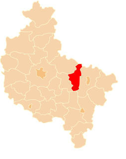
Ciążeń is a village in the administrative district of Gmina Lądek, within Słupca County, Greater Poland Voivodeship, in west-central Poland. It lies approximately 10 kilometres (6 mi) south of Słupca and 65 km (40 mi) east of the regional capital Poznań.
Dąbrowa is a village in the administrative district of Gmina Lądek, within Słupca County, Greater Poland Voivodeship, in west-central Poland. It lies approximately 11 kilometres (7 mi) west of Lądek, 10 km (6 mi) south-west of Słupca, and 62 km (39 mi) east of the regional capital Poznań.
Dolany is a village in the administrative district of Gmina Lądek, within Słupca County, Greater Poland Voivodeship, in west-central Poland. It lies approximately 3 kilometres (2 mi) south-east of Lądek, 13 km (8 mi) south-east of Słupca, and 74 km (46 mi) east of the regional capital Poznań.
Dziedzice is a village in the administrative district of Gmina Lądek, within Słupca County, Greater Poland Voivodeship, in west-central Poland. It lies approximately 6 kilometres (4 mi) west of Lądek, 8 km (5 mi) south of Słupca, and 67 km (42 mi) east of the regional capital Poznań.
Jaroszyn is a village in the administrative district of Gmina Lądek, within Słupca County, Greater Poland Voivodeship, in west-central Poland. It lies approximately 10 kilometres (6 mi) south of Słupca and 69 km (43 mi) east of the regional capital Poznań.
Piotrowo is a village in the administrative district of Gmina Lądek, within Słupca County, Greater Poland Voivodeship, in west-central Poland. It lies approximately 12 kilometres (7 mi) south-east of Słupca and 75 km (47 mi) east of the regional capital Poznań.
Policko is a village in the administrative district of Gmina Lądek, within Słupca County, Greater Poland Voivodeship, in west-central Poland. It lies approximately 5 kilometres (3 mi) west of Lądek, 12 km (7 mi) south of Słupca, and 69 km (43 mi) east of the regional capital Poznań.
Ratyń is a village in the administrative district of Gmina Lądek, within Słupca County, Greater Poland Voivodeship, in west-central Poland. It lies approximately 15 kilometres (9 mi) south-east of Słupca and 78 km (48 mi) east of the regional capital Poznań.
Samarzewo is a village in the administrative district of Gmina Lądek, within Słupca County, Greater Poland Voivodeship, in west-central Poland. It lies approximately 12 kilometres (7 mi) south-west of Słupca and 62 km (39 mi) east of the regional capital Poznań.
Sługocin is a village in the administrative district of Gmina Lądek, within Słupca County, Greater Poland Voivodeship, in west-central Poland. It lies approximately 6 kilometres (4 mi) east of Lądek, 16 km (10 mi) south-east of Słupca, and 79 km (49 mi) east of the regional capital Poznań.
Wacławów is a village in the administrative district of Gmina Lądek, within Słupca County, Greater Poland Voivodeship, in west-central Poland. It lies approximately 5 kilometres (3 mi) east of Lądek, 12 km (7 mi) south-east of Słupca, and 77 km (48 mi) east of the regional capital Poznań.
Wola Koszucka is a village in the administrative district of Gmina Lądek, within Słupca County, Greater Poland Voivodeship, in west-central Poland. It lies approximately 10 kilometres (6 mi) south-east of Słupca and 73 km (45 mi) east of the regional capital Poznań.
Rękawczyn is a village in the administrative district of Gmina Orchowo, within Słupca County, Greater Poland Voivodeship, in west-central Poland. It lies approximately 6 kilometres (4 mi) west of Orchowo, 25 km (16 mi) north of Słupca, and 71 km (44 mi) east of the regional capital Poznań.
Kochowo is a village in the administrative district of Gmina Słupca, within Słupca County, Greater Poland Voivodeship, in west-central Poland. It lies approximately 9 kilometres (6 mi) north-east of Słupca and 70 km (43 mi) east of the regional capital Poznań.
Marcewo is a village in the administrative district of Gmina Słupca, within Słupca County, Greater Poland Voivodeship, in west-central Poland. It lies approximately 8 kilometres (5 mi) north-east of Słupca and 70 km (43 mi) east of the regional capital Poznań.
Młodojewo is a village in the administrative district of Gmina Słupca, within Słupca County, Greater Poland Voivodeship, in west-central Poland. It lies approximately 5 kilometres (3 mi) east of Słupca and 70 km (43 mi) east of the regional capital Poznań.
Oleśnica is a village in the administrative district of Gmina Zagórów, within Słupca County, Greater Poland Voivodeship, in west-central Poland. It lies approximately 3 kilometres (2 mi) east of Zagórów, 16 km (10 mi) south of Słupca, and 74 km (46 mi) east of the regional capital Poznań.
Osiny is a village in the administrative district of Gmina Zagórów, within Słupca County, Greater Poland Voivodeship, in west-central Poland. It lies approximately 5 kilometres (3 mi) south-east of Zagórów, 20 km (12 mi) south of Słupca, and 76 km (47 mi) south-east of the regional capital Poznań.