Related Research Articles
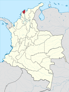
Atlántico is a department of Colombia, located in northern Colombia with the Caribbean Sea to its north, the Bolívar Department to its west and south separated by the Canal del Dique, and the Magdalena Department to its east separated by the Magdalena River. It is the third-smallest of the country's departments but its population of 2,272,170 makes it one of the most densely populated.

The Magdalena River is the principal river of Colombia, flowing northward about 1,528 kilometres (949 mi) through the western half of the country. It takes its name from the biblical figure Mary Magdalene. It is navigable through much of its lower reaches, in spite of the shifting sand bars at the mouth of its delta, as far as Honda, at the downstream base of its rapids. It flows through the Magdalena River Valley.

Puerto Boyacá is a Colombian river-port town and municipality by the Magdalena River in the Boyacá Department, where is also considered a Special Handling Zone due to its port status. Its main industries are oil exploration and processing. In the 1980s and early 1990s, Puerto Boyacá was affected intensively by the Colombian Armed Conflict.

Honda is a town and municipality in the Tolima department of Colombia. The population of the municipality was 26,873 as of the 2005 census. Along with Líbano, Honda is the seat of the Roman Catholic Diocese of Líbano-Honda. The main industries of Honda are tourism, fishing, and cattle-ranching.

The Bogotá River is a major river of the Cundinamarca department of Colombia, crossing the region from the northeast to the southwest and passing along the western limits of Bogotá. The large population and major industrial base in its watershed have resulted in extremely severe pollution problems for the river.

Conewago Creek is an 80.2-mile-long (129.1 km) tributary of the Susquehanna River in Adams and York counties in Pennsylvania in the United States, with its watershed also draining a small portion of Carroll County, Maryland. The source is at an elevation of 1,440 feet (440 m), east of Caledonia State Park, in Franklin Township in Adams County. The mouth is the confluence with the Susquehanna River at York Haven in York County at an elevation of 259 feet (79 m).

The department of Norte de Santander in northwestern Colombia, and its capital, Cúcuta, contains several rivers. The rivers are mostly part of the Maracaibo Lake basin, with the southeastern section located in the Magdalena River basin. Important fluvial elements are the Zulia, Catatumbo and Pamplonita Rivers. The entity in charge of taking care of these hydrology of Norte de Santander is Corponor.

Zapayán is a town and municipality of the Magdalena Department in northern Colombia.

The Sebasticook River is a 76-mile-long (122 km) river in the central part of Maine, in the United States. From its source in Dexter, the upper "Main Stream" section flows generally west and south 30 miles (48 km) to Great Moose Lake. From the outlet of the lake in Hartland, the Sebasticook flows 41 miles (66 km) south to the Kennebec River in Winslow.

Jackson Creek is an 11.0-mile-long (17.7 km) tributary of Sprout Creek in Dutchess County, New York. Via Sprout Creek and Fishkill Creek, water from Jackson Creek flows to the Hudson River. Jackson Creek's subwatershed covers 5,524 acres (22.35 km2) of land.
The Midway River is an 18.8-mile-long (30.3 km) river located in southern Saint Louis County and northeast Carlton County, Minnesota, United States. It is a tributary of the Saint Louis River and flows northeast to southwest. The Midway River rises in the central part of Hermantown, then flows through Midway Township and Thomson Township, before flowing into the Saint Louis River southeast of Cloquet.
The East Branch Mattawamkeag River is a tributary of the Mattawamkeag River in Aroostook County, Maine. From its source in Dudley, the river runs 36 miles (58 km) south and southeast to its confluence with the West Branch Mattawamkeag River in Haynesville, about 10 miles (16 km) west of the Canada–United States border.

The East Branch Penobscot River is a 75.3-mile-long (121.2 km) tributary of Maine's Penobscot River. It flows in Piscataquis County and Penobscot County.

The Fish River is a 69.9-mile-long (112.5 km) river in northern Maine in the United States. It is a tributary of the Saint John River, which flows to the Bay of Fundy in New Brunswick, Canada.
The Little Androscoggin River is a 51.4-mile-long (82.7 km) river in Maine. It flows from Bryant Pond in Woodstock to its confluence with the Androscoggin River in Auburn. The Androscoggin flows into Merrymeeting Bay in the Kennebec River estuary.
The Samaná Norte is a river in Antioquia Department, Colombia and a tributary of the Magdalena River.
Chickamauga Creek is a stream in Georgia, and is a tributary of the Chattahoochee River. The creek is approximately 8.19 miles (13.18 km) long.
The Honda Group is a geological group of the Upper and Middle Magdalena Basins and the adjacent Central and Eastern Ranges of the Colombian Andes. The group, in older literature also defined as formation, is in its present-day type section in the Tatacoa Desert in the department of Huila subdivided into two main formations; La Victoria and Villavieja.

The Magdalena Valley montane forests (NT0136) is an ecoregion in the Andes mountains of central Colombia.

The Mulato-Getudo or Mulato-Jetudo Fault is a sinistral oblique thrust fault in the departments of Tolima, Caldas and Antioquia in central Colombia. The fault has a total length of 187.3 kilometres (116.4 mi) and runs along an average north-northeast to south-southwest strike of 016.7 ± 9 in the Middle Magdalena Valley and along the western foothills of the Central Ranges of the Colombian Andes.
References
- 1 2 "Factors controlling sediment yield in a major South American drainage basin: the Magdalena River, Colombia" (PDF). Archived from the original (PDF) on 2016-03-03. Retrieved 2011-07-13.
- ↑ "La Miel River Watershed". Condesan. Archived from the original on 27 September 2011. Retrieved 5 July 2011.
Coordinates: 05°46′13″N74°40′19″W / 5.77028°N 74.67194°W
| This article related to a river in Colombia is a stub. You can help Wikipedia by expanding it. |