
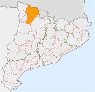
Alta Ribagorça is one of the comarques of Catalonia, Spain. Its capital is Pont de Suert. The highest peak is the Comaloformo in the massif of Bessiberri. Northeast of the region is the western part of the National Aiguas Tortas and Lake of San Mauricio. It is connected with the Aran valley thorough the Vielha tunnel.
Pallars Sobirà is a comarca in the mountainous northwest of Catalonia, Spain. The name means "Upper Pallars", distinguishing it from the more populous Pallars Jussà to its southwest. Its capital and largest municipality is Sort.

Pallars Jussà is a comarca (county) in Catalonia, Spain. It was established as a comarca in 1936, out of the old county of Pallars. The name means "Lower Pallars"; to the northeast and into the mountains is Pallars Sobirà. Its capital and largest municipality is Tremp.

Alt Urgell is a comarca (county) in Catalonia, Spain, a modern representation of part of the historic County of Urgell, seat of the Counts of Urgell and the historic region of Urgellet.

Cerdanya is a comarca in northern Catalonia, in the Pyrenees, on the border of Catalonia with France and Andorra. Within Catalonia. Cerdanya is divided between Catalan provinces of Lleida and Girona. Cerdanya's neighbouring comarques are Alt Urgell, Berguedà, and Ripollès.

Berguedà is an inland comarca (county) in Catalonia, Spain, lying partly in the Pyrenees and Pre-Pyrenees, and partly in the Catalan Central Depression.
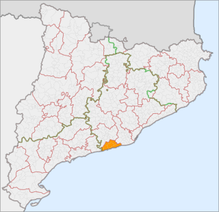
Garraf, better known as El Garraf, is a comarca (county) in the province of Barcelona, Catalonia, northern Spain. It is named after the Garraf Massif.
Sot is a village located in Syrmia, Vojvodina, Serbia. It is situated in the Šid municipality, in the Syrmia District. The village is ethnically mixed and its population numbering 791 people.

Guardiola de Berguedà is a municipality in the comarca of the Berguedà in Catalonia. It is situated at the confluence of the Bastareny and Llobregat rivers in the north of the comarca. It is an important local commercial centre, and for this reason has been less affected by depopulation than other municipalities in the Berguedà. The extraction of lignite is also important to the local economy. The town is served by the C-1411 road from Berga to the Cadí tunnel, and is linked to La Pobla de Lillet and Castellar de n'Hug by the B-402 road. The municipality includes a large exclave to the north-west.
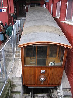
The Gelida Funicular is a funicular railway in the municipality of Gelida in Catalonia, Spain. The line connects Gelida station, on the RENFE, with the centre of the village of Gelida, which is at a higher level. The line was opened in 1924 and modernised in 1984, whilst retaining a heritage ambience.
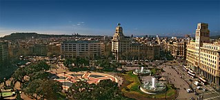
Plaça de Catalunya is a large square in central Barcelona that is generally considered to be both its city centre and the place where the old city and the 19th century-built Eixample meet.
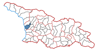
Khobi is a district of Georgia, in the region of Samegrelo-Zemo Svaneti. Its main town is Khobi. The population was 41,240, as of the 2002 census. The total area is 659 square kilometres (254 sq mi).

The following outline is provided as an overview of and topical guide to Catalonia:
Oliveira dos Brejinhos is a municipality in the state of Bahia in the North-East region of Brazil.

Sant Salvador de la Vedella is a Benedictine monastery Catalonia, Spain. The Romanesque building is situated near the municipality of Cercs, in Berguedà comarca, province of Barcelona. It was founded by the monks of the Monastery of Sant Serni de Tavèrnoles in the year 830. Carlot Tavèrnoles became the abbot in the 835. After the 12th century its importance declined. Until the year 1580, it was associated with the seminary at La Seu d'Urgell.
Santa Cecília de Elins is a former Romanesque Benedictine monastery in the municipality of Montferrer i Castellbò, Catalonia, Spain, to the southeast of the village of Cassovall. It is a Bien de Interés Cultural site. The monastery was documented in 865 but fell into decline in the tenth century. On 29 December 1080 the Bishop of Urgell Bernat Guillem consecrated a new church with three altars dedicated to St. Cecilia, Virgin Mary and Santa Fe. During the fourteenth century it fell into decline and in 1383 it was reduced in status to a priory. By 1680 the monastery fell into ruins. It was converted into a farmhouse in the 1940s.

Sant Pere del Burgal is a Romanesque Benedictine monastery in Escaló, in the municipality of La Guingueta d'Àneu, Pallars Sobirà, Catalonia, Spain. The monastery was first mentioned in a precept of Count Raymond of Toulouse in 859. It later became a priory of the abbey of Roussillon. It fell into decline and was secularized in 1570 and confiscated in 1835. It contains frescoes dated to the 11th century.

Sant Pere de Graudescales is a Romanesque Benedictine monastery in La Valldora, in the municipality of Navès, Solsonès, in the Province of Lleida, Catalonia, Spain. It lies to the north of Navès and west of Berga. It was consecrated in 913 by the Bishop of Urgell. From the fifteenth century it was used as a parish church until 1837 when it was abandoned and gradually fell into ruin. Sant Pere de Graudescales was excavated and restored during the second half of the 20th century.

Sant Pere de les Maleses is a Benedictine cave monastery in the municipality of La Pobla de Segur, Pallars Jussà, in the Province of Lleida, Catalonia, Spain. the monastery was first mentioned in 868 when it was dedicated to St. Andrew and was donated to St. Vincent of Oveix, the abbot of Attila. During the tenth or eleventh century it ceased to be owned by Oveix and was rededicated to St. Peter. It later fell under ownership of Santa Maria de Gerri, and lost its status as a monastery. It was secularized in 1592 and from then on became a simple church.

