Lac Vieux Desert is a lake in the United States divided between Gogebic County, Michigan, and Vilas County, Wisconsin. Fed primarily by springs in the surrounding swamps, it is the source of the Wisconsin River, which flows out of its southwest corner. The lake contains a number of small islands, especially in its northeastern lobe, including Draper Island, in Michigan, and Duck Island, in Wisconsin.

Gregoire Lake Provincial Park is a provincial park in Alberta, Canada. It is located close to Highway 63, between Fort McMurray and Lac La Biche, on the northern shore of Gregoire Lake.

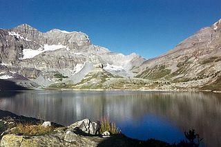
The Lac d'Émosson is a reservoir in the canton of Valais, Switzerland. It is located in the municipalities of Salvan and Finhaut. The closest small city in Switzerland is Martigny. The lake has a surface area of 3.27 km2 and an elevation of 1,930 m. The maximum depth is 180 meters. The purpose of the Émosson Dam is hydroelectric power generation. Water from the reservoir first powers the 189 MW Vallorcine Power Station downstream and just over the border in Vallorcine, France. Water is then sent through a headrace tunnel to the 190 MW La Bâtiaz Power Station, 12 km (7 mi) to the east in Martigny, Switzerland. The drop between the dam and La Bâtiaz Power Station is 1,400 m (4,593 ft).

Lac de Moiry is a reservoir in the municipality of Grimentz, Switzerland.
Lac de Salanfe is a lake in the municipality of Evionnaz, Valais, Switzerland. The reservoir is located at an elevation of 1925 m. Its surface area is 1.62 km2 (0.63 sq mi).

Fond du Lac County Airport is a county-owned public-use airport located 1 mile (2 km) west of the central business district of Fond du Lac, Wisconsin, a city in Fond du Lac County, Wisconsin, United States. It is included in the Federal Aviation Administration (FAA) National Plan of Integrated Airport Systems for 2021–2025, in which it is categorized as a regional general aviation facility. The airport is home to EAA chapter 572.
Lac de Lovenex is a lake in the municipality of St-Gingolph, Valais, Switzerland. It is located an elevation of 1632 m below Mont Gardy. The lake's surface area is 4.7 hectares.
Etang Grenon or Lac Grenon is a lake at Montana in the canton of Valais, Switzerland. Located at an elevation of 1497 m, its surface area is 3.5 ha.
Lac de Gérardmer is a glacial lake at the city of Gérardmer, Vosges, France. It is located in the Vosges mountain range at an elevation of 660 m. With a surface area of 1.16 km² it is the largest natural lake in the Vosges mountain range.

Lac de Capitellu is a lake in Haute-Corse, France. At an elevation of 1930 m, its surface area is 0.055 km2.

Lac de Nino is a lake in Haute-Corse, France. At an elevation of 1743 m, its surface area is 0.065 km².

Lac de Melu is a lake in Corsica, France. At an elevation of 1,710 metres (5,610 ft), its surface area is 0.065 square kilometres (0.025 sq mi). The lake is the source of the Restonica River.
The Hourtin-Carcans Lake is a lake in the natural region of Médoc, located in the French department of Gironde, Aquitaine. It is one of the largest lakes in France, and the largest freshwater lake, by surface area, situated entirely in France. It lies at an elevation of 14 m (46 ft), and has a surface area of 56.67 km2. In winter, its size is exceeded by Lac de Grand-Lieu in the Loire-Atlantique which expands to cover 62.92 km2 but shrinks to 35 km2 in summer.

Lac de Bettaniella is a lake in Corsica, France. At an elevation of 2321 m, its surface area is 0.075 km². In French, it is sometimes alternatively known as Lac de Bellebone or Lac du Rotondo. It is the largest lake in Corsica.
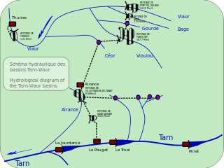
Lac de Saint-Amans is an artificial lake in Le Truel, Aveyron, France close to Villefranche-de-Panat, and 500m above the Tarn. At an elevation of 727 m, it has surface area of 0.11 km2. It is captured by the Barrage de Saint-Amans. It is a holding reservoir, taking water between the Lac de Villefranche-de-Panat and the hydro-electric power station at Le Pouget power station.
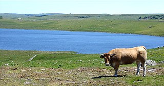
Lac de Saint-Andéol is a lake in Lozère, France, located on the Aubrac plateau. It has an elevation of 1225 m and its surface area is 0.11 km². It is the most important lake of the plateau and known for its legends, and is of glacial origin like the other lakes in this area.
Lac du Tolerme is a lake in Lot, France. At an elevation of 532 m, its surface area is 0.38 km².
Lac de Goria is a lake in Corsica, France. At an elevation of 1852 m, its surface area is 0.04 km².


