Lac de Payolle

Last updated
Lac de Payolle

Payolle Lac.jpg

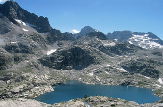
The Lac de Payolle in 2009
Pyrenees topographic map-en.svg
Red pog.svg
Lac de Payolle
Map of the Pyrenees showing the location of Lac de Payolle
Location Hautes-Pyrénées, France
Coordinates 42°56′04″N00°17′50″E / 42.93444°N 0.29722°E / 42.93444; 0.29722 Coordinates: 42°56′04″N00°17′50″E / 42.93444°N 0.29722°E / 42.93444; 0.29722
Surface area 10.1 ha (25 acres)
Surface elevation 1,139 m (3,737 ft)

The Lac de Payolle is an artificial lake in the French Pyrenees. It is located in the communes of Campan and Arreau of the Hautes-Pyrénées department in the Midi-Pyrénées region. Its western shore is the boundary between the communes of Ancizan and Arreau. It is usually completely frozen in winter.

France Republic with mainland in Europe and numerous oversea territories

France, officially the French Republic, is a country whose territory consists of metropolitan France in Western Europe and several overseas regions and territories. The metropolitan area of France extends from the Mediterranean Sea to the English Channel and the North Sea, and from the Rhine to the Atlantic Ocean. It is bordered by Belgium, Luxembourg and Germany to the northeast, Switzerland and Italy to the east, and Andorra and Spain to the south. The overseas territories include French Guiana in South America and several islands in the Atlantic, Pacific and Indian oceans. The country's 18 integral regions span a combined area of 643,801 square kilometres (248,573 sq mi) and a total population of 67.3 million. France, a sovereign state, is a unitary semi-presidential republic with its capital in Paris, the country's largest city and main cultural and commercial centre. Other major urban areas include Lyon, Marseille, Toulouse, Bordeaux, Lille and Nice.

Pyrenees Range of mountains in southwest Europe

The Pyrenees is a range of mountains in southwest Europe that forms a natural border between Spain and France. Reaching a height of 3,404 metres (11,168 ft) altitude at the peak of Aneto, the range separates the Iberian Peninsula from the rest of continental Europe, and extends for about 491 km (305 mi) from the Bay of Biscay to the Mediterranean Sea.

Campan Commune in Occitanie, France

Campan is a commune in the Hautes-Pyrénées department in the Occitanie region of south-western France.

Contents

Geography

It is located at the foot of the Col d'Aspin at 1,139 m (3,737 ft) altitude. With an area of 10 ha (25 acres), it is filled by three mountain streams.

Col dAspin mountain pass

Col d'Aspin is a mountain pass in the French Pyrenees in the department of the Hautes-Pyrénées. It connects Sainte-Marie-de-Campan, in the upper Adour valley, with Arreau, on the River Neste.

Tourism

The lake is an important tourist resort centre: Payolle ski resort, where various activities are practiced such as mountain biking, orienteering, cross-country skiing, snowshoeing, dog sleds, horse or pony rides, paragliding, hiking, etc.

On the lake, fishing is practiced. A tourist fishing route was also laid out around the lake with gateways for fisherman, but also various watersports such as canoeing and sailing. [1]

Sport

Stage 7 of the 2016 Tour de France will finish at the lake on 8 July 2016. [2]

2016 Tour de France 2016 edition of a multiple-stage bicycle race primarily held in France

The 2016 Tour de France was the 103rd edition of the Tour de France, one of cycling's Grand Tours. The 3,529 km (2,193 mi)-long race consisted of 21 stages, starting on 2 July in Mont Saint-Michel, Normandy, and concluding on 24 July with the Champs-Élysées stage in Paris. A total of 198 riders from 22 teams entered the race. The overall general classification was won by Chris Froome of Team Sky, with the second and third places were taken by Romain Bardet and Nairo Quintana, respectively.

See also

Related Research Articles

Hautes-Alpes Department of France

Hautes-Alpes is a department of Provence-Alpes-Côte d'Azur in southeastern France named after the Alps mountain range.

Hautes-Pyrénées Department of France

Hautes-Pyrénées is a department in southwestern France. It is part of the Occitanie region.

Haute-Garonne Department of France

Haute-Garonne is a department in the southwest of France named after the Garonne river. Its main city and capital is Toulouse.

Col du Tourmalet mountain pass

Col du Tourmalet is the highest paved mountain pass in the French Pyrenees, located in the department of Hautes-Pyrénées. Sainte-Marie-de-Campan is at the foot on the eastern side and the ski station La Mongie two-thirds of the way up. The village of Barèges lies on the western side, above the town of Luz-Saint-Sauveur.

Barèges Commune in Occitanie, France

Barèges is a French commune in the Hautes-Pyrénées department in the Occitanie region of south-western France. It is situated in the valley of the Bastan on the former Route nationale 618 on the western side of the Col du Tourmalet.

Cauterets Commune in Occitanie, France

Cauterets is a spa town, a ski resort and a commune in the Hautes-Pyrénées department and the region of Occitanie in south-western France.

Saint-Lary-Soulan Commune in Occitanie, France

Saint-Lary-Soulan is a commune in the Hautes-Pyrénées department in south-western France.

Loudenvielle Commune in Occitanie, France

Loudenvielle is a commune in the Hautes-Pyrénées department in south-western France. On 1 January 2016, the former commune Armenteule was merged into Loudenvielle.

La Clusaz Commune in Auvergne-Rhône-Alpes, France

La Clusaz is a commune in the Haute-Savoie department in the Auvergne-Rhône-Alpes region in south-eastern France.

Montgenèvre Commune in Provence-Alpes-Côte dAzur, France

Montgenèvre is a commune of the Hautes-Alpes department in southeastern France.

Gourette ski resort

Gourette is a winter sports resort in the French Pyrenees. It is located in the commune of Eaux-Bonnes in the département of Pyrénées-Atlantiques, on the D 918 road which passes through the Col d'Aubisque mountain pass. The closest air access is Pau Pyrénées Airport.

Col de Peyresourde mountain pass

The Col de Peyresourde is a mountain pass in the central Pyrenees on the border of the department of Haute-Garonne and Hautes-Pyrénées in France. It is situated on the D618 road between Bagnères-de-Luchon and Arreau.

Laruns Commune in Nouvelle-Aquitaine, France

Laruns is a commune in the Pyrénées-Atlantiques department in south-western France.

Route nationale 618 or RN 618 was a French national road linking Saint-Jean-de-Luz to Argelès-sur-Mer. En route it crossed many of the famous passes in the Pyrenees, immortalized by the Tour de France; hence its name was the "Route of the Pyrénées". In 1970, the road was down-graded and is now the RD 918 from Saint-Jean-de-Luz to Arreau and the RD 618 from Arreau to Argelès Plage.

Val-Louron

Val-Louron is a ski resort in the French Pyrenees, in the department of Hautes-Pyrénées, and the region Midi-Pyrénées.

Peyragudes

Peyragudes is a large ski resort in the French Pyrenees, situated in the departments of Hautes-Pyrénées and Haute-Garonne, in the Region of Occitanie.

Vallée dAure valley

The vallée d'Aure is located in the French Pyrenees, in the Hautes-Pyrénées department, in the region of Midi-Pyrénées.

The canton of Neste, Aure et Louron is an administrative division of the Hautes-Pyrénées department, southwestern France. It was created at the French canton reorganisation which came into effect in March 2015. Its seat is in Capvern.

References

  1. "Lac de Payolle". lacsdespyrenees.com (in French). Retrieved 24 October 2015.
  2. "Tour de France 2016: Chris Froome delight at 'great course'". BBC News. BBC News. 20 October 2015. Retrieved 24 October 2015.