
York County is a county in the eastern part of the Commonwealth of Virginia, located in the Tidewater. As of the 2020 census, the population was 70,045. The county seat is the unincorporated town of Yorktown.

James City County is a county located in the Commonwealth of Virginia. As of the 2020 census, the population was 78,254. Although politically separate from the county, the county seat is the adjacent independent city of Williamsburg.

Yorktown is a census-designated place (CDP) in York County, Virginia. It is the county seat of York County, one of the eight original shires formed in colonial Virginia in 1682. Yorktown's population was 195 as of the 2010 census, while York County's population was 66,134 in the 2011 census estimate.

Hampton Roads is the name of both a body of water in the United States that serves as a wide channel for the James, Nansemond, and Elizabeth rivers between Old Point Comfort and Sewell's Point near where the Chesapeake Bay flows into the Atlantic Ocean, and the surrounding metropolitan region located in the southeastern Virginia and northeastern North Carolina portions of the Tidewater Region.

The Virginia Peninsula is located in southeast Virginia, bounded by the York River, James River, Hampton Roads and Chesapeake Bay. It is sometimes known as the Lower Peninsula to distinguish it from two other peninsulas to the north, the Middle Peninsula and the Northern Neck.

The York River is a navigable estuary, approximately 34 miles (55 km) long, in eastern Virginia in the United States. It ranges in width from 1 mile (1.6 km) at its head to 2.5 miles (4.0 km) near its mouth on the west side of Chesapeake Bay. Its watershed drains an area of the coastal plain of Virginia north and east of Richmond.

Colonial Parkway is a 23-mile (37 km) scenic parkway linking the three points of Virginia's Historic Triangle, Jamestown, Williamsburg, and Yorktown. It is part of the National Park Service's Colonial National Historical Park. Virginia's official state classification for the parkway is State Route 90003. With portions built between 1930 and 1957, it links the three communities via a roadway shielded from views of commercial development. The roadway is toll-free, is free of semi trucks, and has speed limits of around 35 to 45 mph. As a National Scenic Byway and All-American Road, it is also popular with tourists due to the James River and York River ends of the parkway.
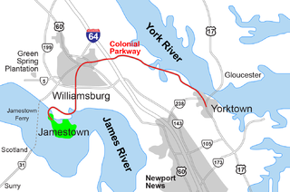
The Historic Triangle includes three historic colonial communities located on the Virginia Peninsula, bounded by the York River on the north and James River on the south. The three points that form the triangle are Jamestown, Colonial Williamsburg, and Yorktown. They feature many restored attractions and are linked by the Colonial Parkway in James City and York counties, and the City of Williamsburg.
Naval Weapons Station Yorktown is a United States Navy base in York County, James City County, and Newport News in the Hampton Roads region of Virginia. It provided a weapons and ammunition storage and loading facility for ships of the United States Atlantic Fleet, and more recently, for those from the Fleet Forces Command.
Magruder was a small unincorporated town in Virginia near Williamsburg in York County. Settled mostly by African-American freedmen after the American Civil War, it once had its own church, post office, cemetery, lodge, and homes. After this land was acquired for the development of the US military reservation known as Camp Peary, all the residents and businesses were displaced. Magruder is considered extinct and one of the lost towns of Virginia.
Camp Peary is an approximately 9,000 acre U.S. military reservation in York County near Williamsburg, Virginia. Officially referred to as an Armed Forces Experimental Training Activity (AFETA) under the authority of the Department of Defense, Camp Peary hosts a covert CIA training facility known as "The Farm", which is used to train officers of the CIA's Directorate of Operations, as well as those of the DIA's Defense Clandestine Service, among other intelligence entities. Its facilities are also available to the members of the intelligence community for "off-site" activities such as conferences and working groups. Camp Peary has a sister facility, "The Point", located in Hertford, North Carolina.
Penniman was an unincorporated town in northwestern York County, Virginia, on the south bank of the York River six miles (9.7 km) northeast of Williamsburg. This was on the Virginia Peninsula and near the Hampton Roads region of southeastern Virginia in the United States.
Grove is an unincorporated community in the southeastern portion of James City County in the Virginia Peninsula subregion of Virginia in the United States. It is located in the center of the Historic Triangle of Colonial Virginia, communities linked by the Colonial Parkway. This area is one of the busiest tourist destinations in the world.

Lee Hall is a community located in the extreme northern portion of the independent city of Newport News in the Commonwealth of Virginia in the United States.

State Route 238 is a primary state highway in the U.S. state of Virginia. The state highway runs 7.75 miles (12.47 km) from U.S. Route 60 in Newport News east to United States Coast Guard Training Center – Yorktown near Yorktown. SR 238 connects Interstate 64 (I-64) with Naval Weapons Station Yorktown, the Yorktown portion of Colonial National Historical Park, and the Coast Guard training center. The majority of SR 238 is part of the Washington–Rochambeau Revolutionary Route.
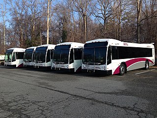
Williamsburg Area Transit Authority (WATA) is a multi-jurisdiction transportation agency providing transit bus and ADA Paratransit services in the City of Williamsburg, James City County, York County in the Historic Triangle area and Surry County, VA of the Virginia Peninsula subregion of Hampton Roads in southeastern Virginia.
Halstead's Point was an unincorporated community in York County, Virginia. In 1918, during World War I, a large tract of land in the area including Halstead's Point was taken by the U.S. Navy to create a military base initially known as a mine depot, where ordnance for military shifts was handled. Today, the lost town of Halstead's Point is unrecognizable, but was located near the Gate 3 of the US Naval Weapons Station Yorktown just off State Route 143 and east of Interstate 64.
Queen's Creek is located in York County in the Virginia Peninsula area of the Hampton Roads region of southeastern Virginia in the United States. From a point of origin near the Waller Mill Reservoir in western York County, it flows northeasterly across the northern half of the Peninsula as a tributary of the York River.

The history of Hampton Roads dates to 1607, when Jamestown was founded. Two wars have taken place in addition to many other historical events.

