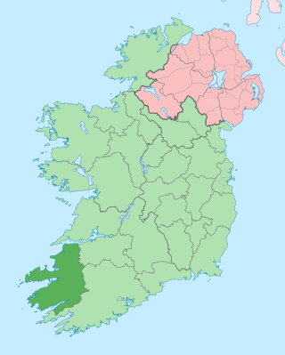
County Kerry is a county in Ireland. It is in the Southern Region and the province of Munster. It is named after the Ciarraige who lived in part of the present county. The population of the county was 156,458 at the 2022 census.

Victoria Falls is a waterfall on the Zambezi River in southern Africa, which provides habitat for several unique species of plants and animals. It is located on the border between Zambia and Zimbabwe and is one of the world's largest waterfalls, with a width of 1,708 m (5,604 ft).
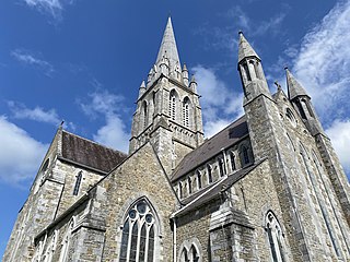
Killarney is a town in County Kerry, southwestern Ireland. The town is on the northeastern shore of Lough Leane, part of Killarney National Park, and is home to St Mary's Cathedral, Ross Castle, Muckross House and Abbey, the Lakes of Killarney, MacGillycuddy's Reeks, Purple Mountain, Mangerton Mountain, Paps Mountain, the Gap of Dunloe and Torc Waterfall. Its natural heritage, history and location on the Ring of Kerry make Killarney a popular tourist destination.

Ross Castle is a 15th-century tower house and keep on the edge of Lough Leane, in Killarney National Park, County Kerry, Ireland. It is the ancestral home of the Chiefs of the Clan O'Donoghue, later associated with the Brownes of Killarney.

Kenmare is a small town in the south of County Kerry, Ireland. The name Kenmare is the anglicised form of Ceann Mara, meaning "head of the sea", referring to the head of Kenmare Bay.

The Ring of Kerry is a 179-kilometre-long (111-mile) circular tourist route in County Kerry, south-western Ireland. Clockwise from Killarney it follows the N71 to Kenmare, then the N70 around the Iveragh Peninsula to Killorglin – passing through Sneem, Waterville, Cahersiveen, and Glenbeigh – before returning to Killarney via the N72.

The Lakes of Killarney are a scenic attraction located in Killarney National Park near Killarney, County Kerry, in Ireland. They consist of three lakes - Lough Leane, Muckross Lake and Upper Lake.

Killarney National Park, near the town of Killarney, County Kerry, was the first national park in Ireland, created when the Muckross Estate was donated to the Irish Free State in 1932. The park has since been substantially expanded and encompasses over 102.89 km2 of diverse ecology, including the Lakes of Killarney, oak and yew woodlands of international importance, and mountain peaks. It has the only red deer herd on mainland Ireland and the most extensive covering of native forest remaining in Ireland. The park is of high ecological value because of the quality, diversity, and extensiveness of many of its habitats and the wide variety of species that they accommodate, some of which are rare. The park was designated a UNESCO Biosphere Reserve in 1981. The park forms part of a Special Area of Conservation and a Special Protection Area.

Muckross House is located on the small Muckross Peninsula between Muckross Lake and Lough Leane, two of the lakes of Killarney, 6 kilometres (3.7 mi) from the town of Killarney in County Kerry, Ireland. In 1932 it was presented by William Bowers Bourn and Arthur Rose Vincent to the Irish nation. It thus became the first National Park in the Irish Free State and formed the basis of the present day Killarney National Park. The house now forms part of a visitor attraction marketed as Muckross House, Gardens and Traditional Farms.

The Kerry Way is a long-distance trail in County Kerry, Ireland. It is a 214-kilometre (133-mile) long circular trail that begins and ends in Killarney and is typically broken into nine stages. It is designated as a National Waymarked Trail by the National Trails Office of the Irish Sports Council and is managed by Kerry County Council, South Kerry Development Partnership and the Kerry Way Committee. The Way circles the Iveragh Peninsula and forms a walkers' version of the Ring of Kerry road tour. It is the longest of Ireland's National Waymarked Trails.

Mary Balfour Herbert (1817–1893) was a British artist. She was born Mary Balfour in 1817, the daughter of James Balfour MP and Lady Eleanor Maitland; they were grandparents of Arthur Balfour 1st Earl Balfour. She grew up in Whittingehame House, East Lothian, Scotland, and travelled widely during her childhood. She took drawing lessons but had no other formal art education.

Torc Mountain, at 535 metres (1,755 ft), is the 329th–highest peak in Ireland on the Arderin list. It is a popular mountain for hill walkers as it has a stone or boarded path from its base at Torc Waterfall to its summit, which has views of the Lakes of Killarney. Torc Mountain is part of the Mangerton Mountain Group range in County Kerry, Ireland.

The Black Valley or Cummeenduff is a remote valley at the southern end of the MacGillycuddy's Reeks mountain range in Kerry, situated south of the Gap of Dunloe and north of Moll's Gap; it is used as a southerly access into the Gap of Dunloe.

The Gap of Dunloe, also recorded as Bearna an Choimín, is a narrow mountain pass running north-south in County Kerry, Ireland, that separates the MacGillycuddy's Reeks mountain range in the west, from the Purple Mountain Group range in the east. It is one of Kerry's most popular tourist destinations on account of its scenery.

Mangerton or Mangerton Mountain, at 838 metres (2,749 ft), is the 19th-highest peak in Ireland on the Arderin list, and the 26th–highest mountain according to the Vandeleur-Lynam list. Mangerton is the tallest mountain in the Mangerton Mountain Group, also called the Mangerton Mountains or the Mountains of East Kerry, a range that includes five other major mountains that have a height above 2,000 feet (610 m). Mangerton's western slopes lie within the Killarney National Park. On Mangerton's north-western face lies a deep corrie lake called the Devil's Punchbowl, which is a popular scenic destination for hill walkers; although the mountain is often overlooked by walkers due to the proximity of its more scenic and accessible neighbour, Torc Mountain. The far northern slopes of Mangerton was the site of an important 13th-century battle between the Mac Cárthaigh, and the FitzGeralds, known as the "Tooreencormick battle site".

Torc Waterfall is a 20 metres (66 ft) high, 110 metres (360 ft) long cascade waterfall formed by the Owengarriff River as it drains from the Devil's Punchbowl corrie lake at Mangerton Mountain. The waterfall, which lies at the base of Torc Mountain, in the Killarney National Park, is 4.3 miles from Killarney in County Kerry, Ireland. The waterfall is a popular site on the Ring of Kerry and the Kerry Way tours.

Moll's Gap or Céim an Daimh, is a mountain pass on the N71 road from Kenmare to Killarney in Kerry, Ireland.

Kenmare House is located on the east shore of Lough Leane and was the principal residence of the Brownes of Killarney, Earls of Kenmare.
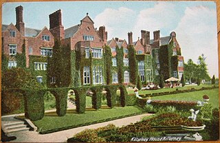
Killarney House is an Irish country home in Killarney, County Kerry, which was built as a replacement for Kenmare House (1726) as the seat of the Earls of Kenmare. The site was chosen by Queen Victoria on her visit to Ireland in 1861.

Glenmacnass Waterfall is an 80-metre high waterfall situated at the head of the Glenmacnass Valley in the Wicklow Mountains in Ireland. The Glenmacnass Waterfall is a popular tourist destination and scenic viewpoint area in the Wicklow Mountains. The Waterfall is bounded to the west by Tonelagee, and to the east by Scarr mountain. The entire Glenmacnass Valley can be accessed by the R115 road, which connects the Sally Gap in the north, to the village of Laragh in the south.


