Gloucester is a cathedral city and the county town of Gloucestershire in the South West of England. Gloucester lies on the River Severn, between the Cotswolds to the east and the Forest of Dean to the west, 19 miles (31 km) east of Monmouth and 17 miles (27 km) east of the border with Wales. Including suburban areas, Gloucester has a population of around 132,000. It is a port, linked via the Gloucester and Sharpness Canal to the Severn Estuary.

Gloucester Cathedral, formally the Cathedral Church of St Peter and the Holy and Indivisible Trinity, in Gloucester, England, stands in the north of the city near the River Severn. It originated with the establishment of a minster, Gloucester Abbey, dedicated to Saint Peter and founded by Osric, King of the Hwicce, in around 679. The subsequent history of the church is complex; Osric's foundation came under the control of the Benedictine Order at the beginning of the 11th century and in around 1058, Ealdred, Bishop of Worcester, established a new abbey "a little further from the place where it had stood". The abbey appears not to have been an initial success, by 1072, the number of attendant monks had reduced to two. The present building was begun by Abbott Serlo in about 1089, following a major fire the previous year.

Baynard's Castle refers to buildings on two neighbouring sites in the City of London, between where Blackfriars station and St Paul's Cathedral now stand. The first was a Norman fortification constructed by Ralph Baynard, 1st feudal baron of Little Dunmow in Essex, and was demolished by King John in 1213. The second was a medieval palace built a short distance to the south-east and later extended, but mostly destroyed in the Great Fire of London in 1666. According to Sir Walter Besant, "There was no house in [London] more interesting than this".

Richmond Green is a recreation area near the centre of Richmond, a town of about 20,000 inhabitants situated in south-west London. Owned by the Crown Estate, it is leased to the London Borough of Richmond upon Thames. The Green, which has been described as "one of the most beautiful urban greens surviving anywhere in England", is roughly square in shape and its open grassland, framed with broadleaf trees, extends to roughly twelve acres. On the north-east side there is also a smaller open space called Little Green. Richmond Green and Little Green are overlooked by a mixture of period townhouses, historic buildings and municipal and commercial establishments including the Richmond Lending Library and Richmond Theatre.

Thetford Priory is a Cluniac monastic house in Thetford, Norfolk, England. Founded in 1103 by Roger Bigod of Norfolk, Thetford was one of the most important monasteries of East Anglia.

Broad Street is a wide street in central Oxford, England, just north of the former city wall. The street is known for its bookshops, including the original Blackwell's bookshop at number 50, located here due to the University of Oxford. Among residents, the street is traditionally known as The Broad.

Blackfriars, Gloucester, England, founded about 1239, is one of the most complete surviving Dominican black friaries in England. Now owned by English Heritage and restored in 1960, it is currently leased to Gloucester City Council and used for weddings, concerts, exhibitions, guided tours, filming, educational events and private hires. The former church, since converted into a house, is a Grade I listed building.
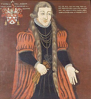
Sir Thomas Bell the Elder (1486–1566) was a cap manufacturer, mayor of Gloucester, and member of Parliament. He was one of the city's largest employers and wealthiest citizens and a great benefactor of the city and its people. He is described in contemporaneous documents as a "capper". He invested much of his wealth in real estate released on the Dissolution of the Monasteries, sometimes in partnership with Richard Duke, of Otterton, Devon, Clerk of the Court of Augmentations.
Whitefriars, also known as the White Friars or The College of Carmelites, Gloucester, England, was a Carmelite friary of which nothing now survives.

St Nicholas Church is a historic church in Westgate Street in the city of Gloucester, England, under the care of The Churches Conservation Trust. It is recorded in the National Heritage List for England as a designated Grade I listed building. Its truncated spire is a landmark in the city centre.

The New Inn, 16 Northgate Street, Gloucester, England, is a timber framed building used as a public house, hotel and restaurant. It is the most complete surviving example of a medieval courtyard inn with galleries in Britain, and is a Grade I listed building. The announcement of Lady Jane Grey's succession to the English throne was made from the Inn gallery in 1553.
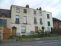
John Wagstaffe (1618–1697), of Ladybellegate House, Longsmith Street, Gloucester, was an English politician.

The Blackfriar is a Grade II* listed public house on Queen Victoria Street in Blackfriars, London.

Bearland House is a grade II* listed building in Longsmith Street, Gloucester, England.
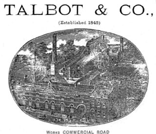
Thomas Talbot was a beverage bottler of Gloucester who founded the Talbot Mineral Water Company in 1845. In 1886, he was elected high sheriff of Gloucester and later became an alderman of the city.
Longsmith Street is a street in Gloucester that runs from Bearland in the north to Southgate Street in the south.

Commercial Road is located in the City of Gloucester, England. It runs from The Quay and Severn Road in the north to Kimbrose Way and Southgate Street in the south. It is joined by Barbican Road and Ladybellegate Street on the north side and by entrances to Gloucester Docks on the south side.
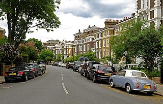
Gloucester Crescent is an 1840s Victorian residential crescent in Camden Town in London which from the early 1960s gained a bohemian reputation as “the trendiest street in London” and "Britain's cleverest street" when it became home for many British writers, artists and intellectuals including Jonathan Miller, George Melly, Alan Bennett and Alice Thomas Ellis.
Eastgate Street is one of the ancient streets in Gloucester, so named because its eastern end was originally the location of the east gate in the city's walls. The part beyond the gate as far as GL1 leisure Centre was part of Barton Street It runs from the crossroads of Northgate, Eastgate, Southgate and Westgate Streets in the West to Barton Street in the East.