
Gloucester is a cathedral city and the county town of Gloucestershire in the South West of England. Gloucester lies on the River Severn, between the Cotswolds to the east and the Forest of Dean to the west; it is sited 19 miles (31 km) east of Monmouth and 17 miles (27 km) east of the border with Wales. Gloucester has a population of around 132,000, including suburban areas. It is a port, linked via the Gloucester and Sharpness Canal to the Severn Estuary.

Gloucester Castle was a Norman-era royal castle situated in the city of Gloucester in Gloucestershire, England. It was demolished in 1787 and replaced by Gloucester Prison.
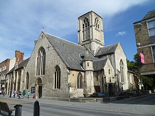
St Mary de Crypt Church, Southgate Street, Gloucester, is an Anglican Church, which was first recorded in 1140 as The Church of the Blessed Mary within Southgate. It is in the Diocese of Gloucester and is located adjacent to the ruins of Greyfriars. It has also been known as Christ Church and St. Mary in the South. St Mary de Crypt is a Grade I listed building.

The New Inn, 16 Northgate Street, Gloucester, England, is a timber framed building used as a public house, hotel and restaurant. It is the most complete surviving example of a medieval courtyard inn with galleries in Britain, and is a Grade I listed building. The announcement of Lady Jane Grey's succession to the English throne was made from the Inn gallery in 1553.

The Folk of Gloucester is a museum which is housed in two of the oldest buildings in the City of Gloucester, a Tudor merchant's house and a 17th-century town house. The museum, at 99–103 Westgate Street, is devoted to the social history of Gloucestershire.
Chester is a city in Cheshire, England. It contains over 650 structures that are designated as listed buildings by English Heritage and included in the National Heritage List for England. Of these, over 500 are listed at Grade II, the lowest of the three gradings given to listed buildings and applied to "buildings of national importance and special interest". This list contains the Grade II listed buildings in the unparished area of the city to the north and west of the Chester city walls.

Gloucester City Council is the local authority for Gloucester, a non-metropolitan district with city status in Gloucestershire, England.

Bearland House is a grade II* listed building in Longsmith Street, Gloucester, England.
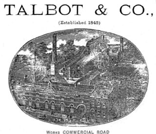
Thomas Talbot was a beverage bottler of Gloucester who founded the Talbot Mineral Water Company in 1845. In 1886, he was elected high sheriff of Gloucester and later became an alderman of the city.
Harrington Gardens is a street which has a communal garden regionally sometimes known as a garden square in the Royal Borough of Kensington and Chelsea in London. The street runs from Collingham Gardens and Collingham Road in the east to Gloucester Road and Stanhope Gardens in the west. It is crossed by Ashburn Place and joined by Colbeck Mews on its north side. It contains several listed buildings including an important group of grade II* buildings on the south side numbered 35 to 45.

Thomas Fulljames FRIBA was an architect active in Gloucestershire, England, in the first half of the nineteenth century. As diocesan surveyor from 1832 until 1870, latterly in partnership with Frederick Sandham Waller, he designed, reconstructed or extended a number of churches in Gloucestershire.

High Orchard was an industrial area of the city of Gloucester in England that was developed in the 19th century on the former orchard of the Priory of Llanthony Secunda (1136). The area was closely associated with Gloucester Docks immediately to the north, and served by the Gloucester and Sharpness Canal and railway transport. It was the site of Fielding & Platt's Atlas Works and a number of other significant local employers.

Norfolk Buildings is a terrace of grade II listed houses at 73-91 Bristol Road, Gloucester, on the east side between Theresa Street and Alma Place.

Worcester Street in the City of Gloucester runs between the junction of Alvin Street and Kingsholm Road in the north and Northgate Street in the south.

Hillfield House is a grade II listed house in Denmark Road, Gloucester, in England. The building, in the Italianate style popularised by Charles Barry, is faced in ashlar Bath stone, with a centrally placed tower and a porte-cochère entrance.

Barton Street is a street in the Barton and Tredworth district of Gloucester that is the location of a number of listed buildings:

Southgate Street is one of the ancient streets in the City of Gloucester, so named because its southern end was originally the location of the south gate in the city's walls. The part beyond the gate as far as Severn Street was sometimes known as Lower Southgate Street. It runs from the crossroads of Northgate, Eastgate, Southgate, and Westgate Streets in the north to Bristol Road in the south.

Northgate Street is a street in the City of Gloucester, so named because its northern end was originally the location of the north gate in the city's walls.
Eastgate Street is one of the ancient streets in Gloucester, so named because its eastern end was originally the location of the east gate in the city's walls. The part beyond the gate as far as GL1 leisure Centre was part of Barton Street It runs from the crossroads of Northgate, Eastgate, Southgate and Westgate Streets in the West to Barton Street in the East.


