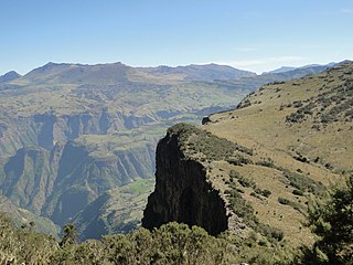
| Lagabora River | |
|---|---|
| Location | |
| Country | Ethiopia |
| Lagabora River | |
|---|---|
| Location | |
| Country | Ethiopia |

The Nile is a major north-flowing river in northeastern Africa. It flows into the Mediterranean Sea. The Nile is the longest river in Africa and has historically been considered the longest river in the world, though this has been contested by research suggesting that the Amazon River is slightly longer. Of the world's major rivers, the Nile is one of the smallest, as measured by annual flow in cubic metres of water. About 6,650 km (4,130 mi) long, its drainage basin covers eleven countries: the Democratic Republic of the Congo, Tanzania, Burundi, Rwanda, Uganda, Kenya, Ethiopia, Eritrea, South Sudan, Republic of the Sudan, and Egypt. In particular, the Nile is the primary water source of Egypt, Sudan and South Sudan. Additionally, the Nile is an important economic river, supporting agriculture and fishing.
Ethiopia is located in the Horn of Africa. It is bordered by Eritrea to the north, Djibouti and Somalia to the east, Sudan and South Sudan to the west, and Kenya to the south. Ethiopia has a high central plateau, the Abyssinian Highlands that varies from 1,290 to 3,000 m above sea level, with some 25 mountains whose peaks rise over 4,000 meters (13,200ft), the highest being Ras Dashen at 4,543 meters (14,538ft).

The Blue Nile is a river originating at Lake Tana in Ethiopia. It travels for approximately 1,450 km (900 mi) through Ethiopia and Sudan. Along with the White Nile, it is one of the two major tributaries of the Nile and supplies about 85.6% of the water to the Nile during the rainy season.

Ethiopia, officially the Federal Democratic Republic of Ethiopia, is a landlocked country in the world and is located in the Horn of Africa. It shares borders with Eritrea to the north, Djibouti to the northeast, Somalia to the east and northeast, Kenya to the south, South Sudan to the west, and Sudan to the northwest. Ethiopia has a total area of 1,100,000 square kilometres. As of 2022, it is home to around 113.5 million inhabitants, making it the 13th-most populous country in the world and the 2nd-most populous in Africa after Nigeria, but Ethiopia is the most populated landlocked country on Earth. The national capital and largest city, Addis Ababa, lies several kilometres west of the East African Rift that splits the country into the African and Somali tectonic plates.

The Second Italo-Ethiopian War, also referred to as the Second Italo-Abyssinian War, was a war of aggression which was fought between Italy and Ethiopia from October 1935 to February 1937. In Ethiopia it is often referred to simply as the Italian Invasion, and in Italy as the Ethiopian War. It is seen as an example of the expansionist policy that characterized the Axis powers and the ineffectiveness of the League of Nations before the outbreak of the Second World War.
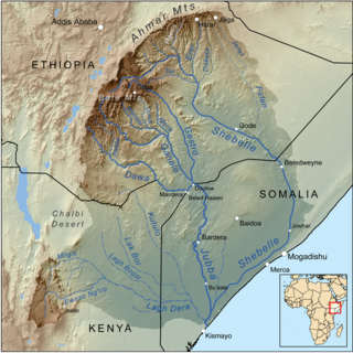
The Shebelle River begins in the highlands of Ethiopia, and then flows southeast into Somalia towards Mogadishu. Near Mogadishu, it turns sharply southwest, where it follows the coast. Below Mogadishu, the river becomes seasonal. During most years, the river dries up near the mouth of the Jubba River, while in seasons of heavy rainfall, the river actually reaches the Jubba and thus the Somali Sea.

Dire Dawa is a city in eastern Ethiopia near the Oromia and Somali Region border and one of two chartered cities in Ethiopia. Dire Dawa alongside present-day Sitti Zone were a part of the Dire Dawa autonomous region stipulated in the 1987 Ethiopian Constitution until 1993 when it was split by the federal government into a separately administered chartered city. This was due to the ongoing clashes between the OLF and IGLF and prevented any further escalation.

The Tekezé or Täkkäze River, also spelled Takkaze, is a major river of Ethiopia. For part of its course it forms a section of the westernmost border of Ethiopia and Eritrea. The river is also known as the Setit in Eritrea, western Ethiopia, and eastern Sudan. According to materials published by the Ethiopian Central Statistical Agency, the Tekezé River is 608 kilometers (378 mi) long. The canyon which it has created is the deepest in Africa and one of the deepest in the world, at some points having a depth of over 2000 meters.

The Awash is a major river of Ethiopia. Its course is entirely contained within the boundaries of Ethiopia and empties into a chain of interconnected lakes that begin with Lake Gargori and end with Lake Abbe on the border with Djibouti, some 100 kilometres from the head of the Gulf of Tadjoura. It is the principal stream of an endorheic drainage basin covering parts of the Amhara, Oromia and Somali Regions, as well as the southern half of the Afar Region.

The Omo River in southern Ethiopia is the largest Ethiopian river outside the Nile Basin. Its course is entirely contained within the boundaries of Ethiopia, and it empties into Lake Turkana on the border with Kenya. The river is the principal stream of an endorheic drainage basin, the Turkana Basin.

The Anyuak, also known as Anyua and Anywaa, are a Luo Nilotic ethnic group inhabiting parts of East Africa. The Anuak belong to the larger Luo family group. Their language is referred to as Dha-Anywaa. They are primarily found in Gambela Region in western Ethiopia, South Sudan as well as Sudan. Group members number between 200,000 and 300,000 people worldwide. Many of the Anyuak people now follow Christianity. It is one of the first of the Nilotic groups to become almost entirely Christian, following the Shilluk people.
The Kingdom of Kaffa was a kingdom located in what is now Ethiopia from 1390 to 1897, with its first capital at Bonga. The Gojeb River formed its northern border, beyond which lay the Gibe kingdoms; to the east the territory of the Konta and Kullo peoples lay between Kaffa and the Omo River; to the south numerous subgroups of the Gimira people, and to the west lay the Majangir people. The native language, also known as Kaffa, is one of the Omotic group of languages.

The Baro River or Baro/Openo Wenz, known to the Anuak as Openo River, is a river in southwestern Ethiopia, which defines part of Ethiopian border with South Sudan. From its source in the Ethiopian Highlands it flows west for 306 kilometres (190 mi) to join the Pibor River. The Baro-Pibor confluence marks the beginning of the Sobat River, a tributary of the White Nile.

The Sultanate of Ifat, known as Wafāt or Awfāt in Arabic texts, was a medieval Sunni Muslim state in the eastern regions of the Horn of Africa between the late 13th century and early 15th century. It was formed in present-day Ethiopia around eastern Shewa. Led by the Walashma dynasty, the polity stretched from Zequalla to the port city of Zeila. The kingdom ruled over parts of what are now Ethiopia, Djibouti and Somaliland.
Articles related to Ethiopia include:
Energy in Ethiopia is energy and electricity production, consumption, transport, exportation, and importation in Ethiopia.
Ethiopia is called the water tower of Africa due to its combination of mountainous areas with a comparatively large share of water resources in Africa. Only a fraction of this potential has been harnessed so far, 1% at the beginning of the 21st century. In order to become the powerhouse of Africa, Ethiopia is actively exploiting its water resources by building dams, reservoirs, irrigation and diversion canals and hydropower stations. The benefits of the dams are not only limited to hydropower. Many dams are multi-purpose dams that are also designed to provide water for irrigation, drinking water and flood control. However, hydropower is expected to be the main benefit of the dams.

The Grand Ethiopian Renaissance Dam, formerly known as the Millennium Dam and sometimes referred to as the Hidase Dam, is a gravity dam on the Blue Nile River in Ethiopia under construction since 2011. The dam is in the Benishangul-Gumuz Region of Ethiopia, about 45 km (28 mi) east of the border with Sudan.

Ethiopia generates most of its electricity from renewable energy, mainly hydropower.