Lago dell'Antenna

Last updated
Lago dell'Antenna
Lago dell'Antenna da SP40.png
The lake from provincial road nr. 40
Italy relief location map.jpg
Red pog.svg
Lago dell'Antenna
Location Province of Genova, Liguria
Coordinates 44°28′52.25″N8°35′49.13″E / 44.4811806°N 8.5969806°E / 44.4811806; 8.5969806
Type artificial lake
Primary inflows Orba
Primary outflows Orba
Basin  countriesItaly
Built1922 (1922) - 1946 (1946)
Surface area0.0225 km2 (0.0087 sq mi) [1]
Max. depth14.3 m (47 ft) [1]
Water volume0.000082 km3 (2.0×10⁻⁵ cu mi) [1]
Surface elevation557 m (1,827 ft) [1]

Lago dell'Antenna is an artificial lake in north-west Italy, located in the Genoa (Liguria). Concerned comunes are Urbe and Sassello. [2]

Contents

Geography

The lake was created by blocking the Orba with a dam about two kilometres upstream of San Pietro d'Urbe, in order to produce electricity. [3] Its name comes from Monte Antenna (821 m), a mountain which overlooks the left banks of the lake. The right banks of the reservoir are flanked by the provincial road nr. 40 Urbe - Vara - Passo del Faiallo [4] and from Bric del Sozzo (650 m). The lake is located on the northern border of Parco naturale regionale del Beigua, which encompasses its left shore.

History

Antenna lake was realised in 1922 in order to provide water to the hydroelectric power plant of the Cotonificio Ligure, located in San Pietro d'Orba. During the 1940s the reservoir capacity was considered insufficient and started dam extension works which ended in 1946, bringing the reservoir capacity up to around 50.000 m³. Present-day dam is a masonry arch-gravity dam; it finally inspection took place in February 1952. [1] Nowadays the reservoir capacity is restricted by the sedimentation on the lake bed and is estimated to be around 30,000 m³.

Fishing

Antenna dam Diga di Antenna.png
Antenna dam

Lake Antenna is classified, following Province of Savona fishing map, as a B category water body (Acque di categoria B), thus mixed population water. The lake is also defined as touristic fishing reserve (riserva di pesca turistica), and is restocked with rainbow trouts when authorised by Parco del Beigua. Restocking with brown trouts is not permitted because they are not considered native fish. The lake is the subject of a yearly fauna survey. [5] Access rules are defined by Provincia di Savona administration. [6]

Related Research Articles

<span class="mw-page-title-main">Sassello</span> Comune in Liguria, Italy

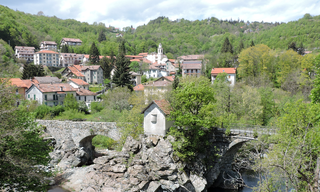
Sassello is a comune (municipality) in the Province of Savona in the Italian region Liguria, located about 58 kilometres (36 mi) west of Genoa and about 26 kilometres (16 mi) north of Savona in the northern side of the Ligurian Apennines. It is the birthplace of Blessed Chiara Badano.

<span class="mw-page-title-main">Urbe</span> Comune in Liguria, Italy

Urbe is a comune (municipality) in the Province of Savona in the Italian region Liguria, located about 30 kilometres (19 mi) northwest of Genoa and about 25 kilometres (16 mi) northeast of Savona. As of 31 December 2004, it had a population of 847 and an area of 31.5 square kilometres (12.2 sq mi).

<span class="mw-page-title-main">Cogoleto</span> Comune in Liguria, Italy

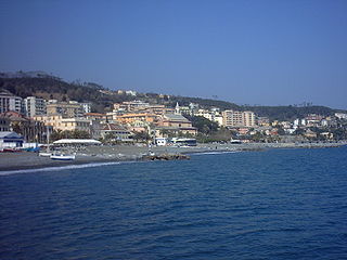
Cogoleto is a comune (municipality) in the Metropolitan City of Genoa in the Italian region Liguria, located about 25 kilometres (16 mi) west of Genova. Its territory extends from the sea to the Ligurian Apennines; it is part of the Natural Regional Park of Monte Beigua.

<span class="mw-page-title-main">Tiglieto</span> Comune in Liguria, Italy

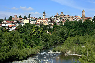
Tiglieto is a comune (municipality) in the Metropolitan City of Genoa in the Italian region Liguria, located about 52 kilometres (32 mi) northwest of Genoa.

<span class="mw-page-title-main">Orba (river)</span> River in Italy

The Orba is a torrent of northern Italy.

<span class="mw-page-title-main">Lago di Ortiglieto</span> Artificial lake in Liguria, Piemonte

Lago di Ortiglieto is a reservoir in northwest Italy which straddles the Metropolitan City of Genoa in Liguria, and the Province of Alessandria in Piedmont.

<span class="mw-page-title-main">Monte Reixa</span> Mountain in Liguria, Italy

Monte Reixa is a mountain in Liguria, northern Italy, part of the Ligurian Apennines.

<i>Alta Via dei Monti Liguri</i>

The Alta Via dei Monti Liguri is a long-distance waymarked hiking trail in the Italian region of Liguria. In about 440 kilometres (270 mi) and 44 day hikes, it runs through the arc formed by Ligurian Alps and Ligurian Apennines from Ventimiglia to Ceparana.

<span class="mw-page-title-main">Bergeggi (island)</span>

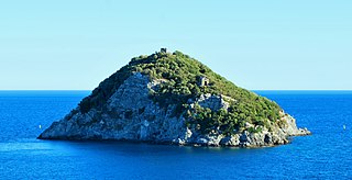
Bergeggi is an island which lies in the Ligurian Sea off the coast near the village of Bergeggi in the Province of Savona, Liguria, Italy.

The Beigua Natural Regional Park is a natural park located in province of Savona and the Metropolitan City of Genoa, both in Liguria (Italy). It's the largest protected area of the region. It gets the name from the highest mountain of the area, Monte Beigua.

<span class="mw-page-title-main">Bric del Dente</span> Mountain in Italy

Bric del Dente is a 1107 metres high mountain of the Apennines located in the Italian region of Liguria.

<span class="mw-page-title-main">Stura di Ovada</span> Italian river

The Stura di Ovada is a 32.9-kilometre (20.4 mi) stream of Liguria and Piedmont (Italy); it is the main tributary of the Orba.

<span class="mw-page-title-main">Passo del Faiallo</span> Mountain pass in Italy

Passo del Faiallo (1044 m) is a mountain pass between the Province of Savona (SV) and the Metropolitan City of Genoa (GE). It connects Urbe (SV) with Passo del Turchino (GE), both in Liguria.

<span class="mw-page-title-main">Rocca Barbena</span> Mountain in Italy

Rocca Barbena is a 1,142-metre (3,747 ft) high mountain in the Ligurian Prealps in Italy.

<span class="mw-page-title-main">Steria (creek)</span> Stream in Liguria, Italy

The Steria or Cervo is a 9.6-kilometre (6.0 mi) stream of Liguria (Italy).

<span class="mw-page-title-main">Merula (creek)</span> Stream in Liguria, Italy

The Merula is a 14.7-kilometre (9.1 mi) stream of Liguria (Italy).

<span class="mw-page-title-main">Giara di Rezzo</span> Stream in Liguria, Italy

The Giara di Rezzo is a 14-kilometre (8.7 mi) stream of Liguria, Italy.

<span class="mw-page-title-main">Monte Monega</span> Mountain in Italy

Monte Monega is a 1,882-metre (6,175 ft) mountain of the Ligurian Alps, in Italy.

<span class="mw-page-title-main">Carmo di Brocchi</span> Mountain in Italy

Carmo di Brocchi is a 1,610-metre (5,282 ft) mountain of the Ligurian Alps, in Italy.

<span class="mw-page-title-main">Brevenna</span> Stream in Liguria, Italy

The Brevenna is a 16.138-kilometre (10.028 mi) creek of Liguria, Italy.

References

  1. 1 2 3 4 5 Settore Difesa del Suolo- Servizio di Protezione Civile. Scheda tecnica sbarramento (PDF). Provincia di Savona. Archived from the original (PDF) on 2016-08-06. Retrieved 2016-09-24.
  2. "Limiti Amministrativi (Comunali, Provinciali, Regionali) sc. 1:25000 - ed. 2011". geoportale.regione.liguria.it. Regione Liguria. Retrieved 2016-09-24.
  3. "Rivista geografica italiana". Vol. 80. Florence: Società di studi geografici. 1973. pp. 284–286.
  4. "Strada Provinciale SP 40 - Urbe - Vara - Passo del Faiallo". www.provincia.savona.it. Provincia di Savona. Archived from the original on 2016-08-06. Retrieved 2016-05-30.
  5. "Determinazione del direttore n.28 del 4 febbraio 2015" (PDF). Ente Parco del Beigua. Archived from the original (PDF) on 2022-03-07. Retrieved 2016-05-30.
  6. m. pi. (2011-04-29). "La Provincia consente apertura della pesca nella diga dell'Antenna di Urbe". www.savonanews.it. Retrieved 2016-05-30.