Parco naturale regionale del Beigua

Last updated

Parco naturale regionale del Beigua
Beigua Geopark
IUCN category V (protected landscape/seascape)
Panorama dal Bric Resunnou.png
Italy relief location map.jpg
Red pog.svg
Location Liguria, Italy
Nearest city Savona and Genoa
Coordinates 44°25′58″N8°32′55″E / 44.4328°N 8.5486°E / 44.4328; 8.5486 Coordinates: 44°25′58″N8°32′55″E / 44.4328°N 8.5486°E / 44.4328; 8.5486 [1]
Area8,715 ha (21,540 acres)
Established1985, 1995
Governing bodyEnte Parco del Beigua (Arenzano)
www.parcobeigua.it

The Beigua Natural Regional Park (in Italian Parco naturale regionale del Beigua) is a natural park located in province of Savona and the Metropolitan City of Genoa, both in Liguria (Italy). It's the largest protected area of the region. [2] It gets the name from the highest mountain of the area, Monte Beigua.

Contents

History

The natural park was established by the l.r. (regional law, in Italian legge regionale ) nr. 16 April the 9th 1985 as modified by the l.r. nr. 12 February the 22nd 1995. [3]

During March 2005 the Beigua Geopark was recognised as a part of the European Geoparks Network. [4]

Geography

Northern slopes of Cima Fontanaccia. Cima Fontanaccia da nord a sin genova.png
Northern slopes of Cima Fontanaccia.

Situated in the inland of the Italian Riviera between Savona and Genoa, the park covers a very interesting area of the Ligurian Apennines. its protected territory, over 87 square kilometres (34 sq mi), includes 26 km of the Apenninic watershed dividing Pianura Padana (tributary of the Adriatic Sea) from the Ligurian Sea drainage basin.

The park encompasses three SCIs and one SPA of the Natura 2000 network: [5]

The geopark is wider than the Natural Regional Park and reaches 39,230 ha (96,900 acres) of protected territory. [4]

Main summits of the park

Among the summits located in the park can be cited Monte Beigua (1287 m), Bric del Dente (1107 m), Cima Fontanaccia (1153 m), Monte Rama (1150 m), Monte Reixa (1183 m) and Monte Sciguello (1103 m).

Concerned municipalities

Visitor's centre located in Villa Bagnara (Masone). Masone-villa Bagnara.jpg
Visitor's centre located in Villa Bagnara (Masone).

The natural park is shared among the following municipalities: Arenzano, Campo Ligure, Cogoleto, Genova, Masone, Rossiglione, Sassello, Stella, Tiglieto, Varazze

Geology

The park offers a wide range of geological features, most of them tied to a portion of Jurassic oceanic crust modified during the Alpine orogeny. Among the predominant rocks of the area can be cited gabbros, peridotites and serpentinites, here and there covered by pillow basalts and latter sedimentary and metamorphic layers. Several serpentinite quarries, active in the past, are now abandoned. [6]

Wildlife

Carlina acaulis on monte Reixa. Carlina acaulis sul Reixa.jpg
Carlina acaulis on monte Reixa.

Some rare plants of the park are Viola bertolonii , Cerastium utriense , Asplenium cuneifolium , Daphne cneorum , Cheilantes marantae . Mountain mires and wetlands host locally endangered species of amphibians as alpine newt, northern crested newt and Malpolon monspessulanus . In the park are very common larger animals as wild boars, roe and fallow deers. [7]

Hiking

Around 500 km of footpaths are available within the park, that is crossed from west to east by the Alta Via dei Monti Liguri , a long-distance trail from Ventimiglia (province of Imperia) to Bolano (province of La Spezia). [8]

Bibliography

Related Research Articles

Ligurian Alps

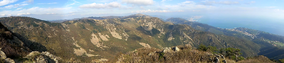
The Ligurian Alps are a mountain range in northwestern Italy. A small part is located in France. They form the south-western extremity of the Alps, separated from the Apennines by the Colle di Cadibona. The Col de Tende and the Vermenagna valley separate them from the Maritime Alps. They form the border between Piedmont in the north and Liguria in the south.

Arenzano Comune in Liguria, Italy

Arenzano is a coastal town and comune in the Metropolitan City of Genoa, Liguria, northern Italy, facing the Ligurian Sea. As of 2017, it has a population of 11,445. This varies during the holiday seasons due to tourist flow.

Cogoleto Comune in Liguria, Italy

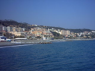
Cogoleto is a comune (municipality) in the Metropolitan City of Genoa in the Italian region Liguria, located about 25 kilometres (16 mi) west of Genova. Its territory extends from the sea to the Ligurian Apennines; it is part of the Natural Regional Park of Monte Beigua.

Sacro Monte di Crea Christian devotional complex in Serralunga di Crea, Piedmont, Italy

The Sacro Monte di Crea is a Roman Catholic sanctuary in the comune of Serralunga di Crea, Piedmont, northern Italy. It is reached via a steeply ascending route which winds through a wooded natural park, whose flora was catalogued by the Casalese photographer and polymath Francesco Negri.

Monte Beigua

Monte Beigua is a mountain in the Ligurian Apennines in Liguria, northern Italy, between the two communes of Varazze and Sassello.

Monte Frontè

Monte Frontè is a mountain in Liguria, northern Italy, part of the Alps. It is located in the province of province of Imperia. It lies at an altitude of 2,152 metres. After Monte Saccarello it is the second highest peak in the Ligurian region.

Monte Reixa Mountain in Liguria, Italy

Monte Reixa is a mountain in Liguria, northern Italy, part of the Ligurian Appennines.

Monte Saccarello

Monte Saccarello (Italian) or Mont Saccarel (French) is a mountain located on the French-Italian border between Liguria, Piedmont and Provence-Alpes-Côte d'Azur.

<i>Alta Via dei Monti Liguri</i>

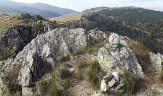
The Alta Via dei Monti Liguri is a long-distance waymarked hiking trail in the Italian region of Liguria. In about 440 kilometres (270 mi) and 44 day hikes, it runs through the arc formed by Ligurian Alps and Ligurian Apennines from Ventimiglia to Ceparana.

Cima Garlenda Mountain in Italy

Cima Garlenda is a 2141 m mountain of the Ligurian Alps, in Italy. After Monte Saccarello and Monte Frontè it is the third Ligurian summit.

Cima Fontanaccia Mountain in the Apennines

Cima Fontanaccia is a 1153 metres high mountain in the Ligurian Apennines, in Italy.

Regional Natural Park of the Ligurian Alps Nature reserve in Italy

The Regional Natural Park of the Ligurian Alps is a natural park in Province of Imperia. It was established in 2007 by the legge regionale nr.34 of 15/11/2007.

Bric del Dente Mountain in Italy

Bric del Dente is a 1107 metres high mountain of the Apennines located in the Italian region of Liguria.

Antola Natural Regional Park

The Antola Natural Regional Park is a natural park in Metropolitan City of Genoa. It gets the name from the highest mountain of the area, Monte Antola.

Parco naturale delle Capanne di Marcarolo

The Capanne di Marcarolo Natural Regional Park is a natural park in the province of Alessandria. It gets the name from a small village in the protected area, Capanne di Marcarolo.

Rocca Barbena Mountain in Italy

Rocca Barbena is a 1,142-metre (3,747 ft) high mountain in the Ligurian Prealps in Italy.

Monte Monega Mountain in Italy

Monte Monega is a 1,882-metre (6,175 ft) mountain of the Ligurian Alps, in Italy.

Carmo di Brocchi Mountain in Italy

Carmo di Brocchi is a 1,610-metre (5,282 ft) mountain of the Ligurian Alps, in Italy.

Natural Park of Marguareis Nature reserve in Italy

The Natural Park of Marguareis(in Italian Parco Naturale del Marguareis) is a regional natural park of the Ligurian Alps located in the Province of Cuneo.

References

  1. Coordinates from wikidata
  2. "Beigua European & Global Geopark". www.parcobeigua.it. Retrieved 20 February 2016.
  3. "Elenco ufficiale delle aree protette (EUAP) – 5º Aggiornamento – Supplemento ordinario n. 144 alla Gazzetta Ufficiale n. 205 del 4 settembre 2003" (PDF). www.parks.it. Ministero dell'ambiente e della tutela del territorio e del mare . Retrieved 16 February 2016.
  4. 1 2 "Un patrimonio geologico riconosciuto a livello mondiale – Beigua Geopark". www.parks.it. Retrieved 20 February 2016.
  5. "La Rete Natura 2000". www.parcobeigua.it. Retrieved 11 February 2016.
  6. "Patrimonio Geologico del Beigua Geopark". ww.parcobeigua.it. Ente Parco del Beigua. Retrieved 19 February 2016.
  7. "Un Parco per la tutela della biodiversità". www.parks.it. Federparchi. Retrieved 20 February 2016.
  8. "Camminare lungo l'Alta via dei monti liguri". trekkinginliguria.it. (link: melogno.wp). Retrieved 21 February 2016.