
Liguria is a region of north-western Italy; its capital is Genoa. Its territory is crossed by the Alps and the Apennines mountain range and is roughly coextensive with the former territory of the Republic of Genoa. Liguria is bordered by France to the west, Piedmont to the north, and Emilia-Romagna and Tuscany to the east. It rests on the Ligurian Sea, and has a population of 1,557,533. The region is part of the Alps–Mediterranean Euroregion.

The Ligurian Alps are a mountain range in northwestern Italy. A small part is located in France. They form the south-western extremity of the Alps, separated from the Apennines by the Colle di Cadibona. The Col de Tende and the Vermenagna valley separate them from the Maritime Alps. They form the border between Piedmont in the north and Liguria in the south.

Arenzano is a coastal town and comune in the Metropolitan City of Genoa, Liguria, northern Italy, facing the Ligurian Sea. As of 2017, it has a population of 11,445. This varies during the holiday seasons due to tourist flow.

Sassello is a comune (municipality) in the Province of Savona in the Italian region Liguria, located about 58 kilometres (36 mi) west of Genoa and about 26 kilometres (16 mi) north of Savona in the northern side of the Ligurian Apennines. It is the birthplace of Blessed Chiara Badano.
Varazze is a comune (municipality) in the Province of Savona in the Italian region of Liguria, located about 30 kilometres (19 mi) west of Genoa and about 11 kilometres (7 mi) northeast of Savona in the Riviera di Ponente. Nearby in the Ligurian Apennines is the Monte Beigua with its Natural Regional Park.
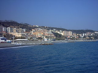
Cogoleto is a comune (municipality) in the Metropolitan City of Genoa in the Italian region Liguria, located about 25 kilometres (16 mi) west of Genova. Its territory extends from the sea to the Ligurian Apennines; it is part of the Natural Regional Park of Monte Beigua.

Rossiglione is a comune (municipality) in the Metropolitan City of Genoa in the Italian region Liguria, located about 41 kilometres (25 mi) northwest of Genoa. It has a population of 2 558 people.

The Orto Botanico di Villa Beuca is a botanical garden situated in Beuca, on a terrace nearly 100 meters above the sea located around the Villa Beuca not far from the slopes of the Regional Natural Park of Beigua, in Cogoleto, Province of Genoa, Liguria, Italy. The garden is currently open to the public by appointment on Saturday: for groups and schools, guided tours may be organized; an admission fee is charged.

Mont Bégo is a mountain in the Mercantour massif of the Maritime Alps, in southern France, with an elevation of 2,872 metres (9,423 ft). It is included in the Vallée des Merveilles.

Monte Frontè is a mountain in Liguria, northern Italy, part of the Alps. It is located in the province of province of Imperia. It lies at an altitude of 2,152 metres. After Monte Saccarello it is the second highest peak in the Ligurian region.
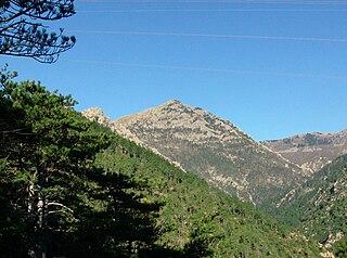
Monte Rama is a mountain in Liguria, northern Italy, part of the Ligurian Apennines.

Monte Reixa is a mountain in Liguria, northern Italy, part of the Ligurian Apennines.

Monte Sciguello is a mountain in Liguria, northern Italy, part of the Ligurian Apennines.

Monte Settepani is 1,386 metres high mountain in Liguria, northern Italy, part of the Ligurian Prealps.

The Alta Via dei Monti Liguri is a long-distance waymarked hiking trail in the Italian region of Liguria. In about 440 kilometres (270 mi) and 44 day hikes, it runs through the arc formed by Ligurian Alps and Ligurian Apennines from Ventimiglia to Ceparana.
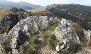
Cima Fontanaccia is a 1153 metres high mountain in the Ligurian Apennines, in Italy.
The Beigua Natural Regional Park is a natural park located in province of Savona and the Metropolitan City of Genoa, both in Liguria (Italy). It's the largest protected area of the region. It gets the name from the highest mountain of the area, Monte Beigua.

Bric del Dente is a 1107 metres high mountain of the Apennines located in the Italian region of Liguria.

Passo del Faiallo (1044 m) is a mountain pass between the Province of Savona (SV) and the Metropolitan City of Genoa (GE). It connects Urbe (SV) with Passo del Turchino (GE), both in Liguria.

Monte Peso Grande o Castell'Ermo (1.092 m) is a mountain of the Ligurian Prealps, the eastern section of the Ligurian Alps.

