Ronco di Maglio

Last updated
Ronco di Maglio
Ronco di Maglio vista da sud.png
The mountain as viewed from South
Highest point
Elevation 1,109.5 m (3,640 ft) [1]
Prominence 315.5 [2] [1]
Coordinates 44°17′41″N8°13′21″E / 44.2947°N 8.22253°E / 44.2947; 8.22253 Coordinates: 44°17′41″N8°13′21″E / 44.2947°N 8.22253°E / 44.2947; 8.22253
Geography
Alps location map.png
Red triangle with thick white border.svg
Ronco di Maglio
Location in the Alps
Location Liguria, Italy
Parent range Ligurian Alps

Ronco di Maglio is a mountain in Liguria, northern Italy, part of the Ligurian Prealps.

Contents

Geography

The mountain is located near the centre of the Provincia di Savona, between the comuni (municipalities) of Osiglia and Bormida, and is one of the highest of the Ligurian Prealps. It stands on the ridge dividing two valleys belonging to the Bormida watershed, Osiglia valley (west) and Pallare valley. Going South a saddle at 858 metes divides it from Bric della Croce (911 m), while northwards the ridge lowers and ends up between Plodio and Millesimo. [1] Near the summit can be seen a few pine trees remaining from a thick coniferous wood which used to grow in there.

History

Around the mountain top some remains of Napoleonic trenches can be seen. [3]

Access to the summit

Summit cairn Cime di Ronco di Maglio libro di vetta.png
Summit cairn

Ronco di Maglio can be ascended by various waymarked foothpats; among them can be reminded the one starting from Colla Baltera (794 m [1] ) which, passing through Bric della Croce, reaches the summit from South. The mountain is also accessible by mountain bike. [4] The mountain top is wooded and almost flat; on its highest point stands a cairn with a summit register.

Nature conservation

The mountain and its surrounding area are part of a SIC (Site of Community Importance) called Ronco di Maglio (code: IT1322216). [5]

Related Research Articles

Bormida, Liguria Comune in Liguria, Italy

Bormida, with a population of 453 spread over an area of 22.4 square kilometres (8.6 sq mi), is a rural municipality of the Province of Savona in the Italian region Liguria. The municipality is a member of the Comunità Montana Alta Val Bormida. On May 11, 2017 it was reported that due to a declining population the town's mayor Daniele Galliano recommended a proposal to the Ligurian regional government, and not a confirmed measure, but that it hopes to enact the bonus in 2018 of offering €2,000 ($2,175) and very low rents starting at $50 per month for anyone willing to move there.

Bric delle Camere Mountain in Italy

Bric delle Camere is a mountain in northern Italy, part of the Ligurian Apennines. It is located in the provinces of Genoa and Alessandria. It lies at an altitude of 1016 metres.

Monte Buio Mountain in Italy

Monte Buio is a mountain in Liguria, northern Italy, part of the Ligurian Apennines. It is located between the provinces of Genoa and Alessandria. It lies at an altitude of 1400 metres.

Monte Carmo di Loano Mountain in Italy

Monte Carmo di Loano is a mountain in Liguria, northern Italy, part of the Ligurian Prealps. It is located in the province of Savona. It lies at an altitude of 1389 metres.

Monte Galero Mountain in Italy

Monte Galero is a mountain in Liguria, northern Italy, part of the Alps. It is located in the provinces of Savona and Cuneo. It lies at an altitude of 1708 metres and, after Monte Armetta, is the second highest summit of the Ligurian Prealps.

Monte Settepani Mountain in Italy

Monte Settepani is 1,386 metres high mountain in Liguria, northern Italy, part of the Ligurian Prealps.

Bric Gettina Mountain in Italy

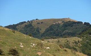
Bric Gettina is a 1025 metres high mountain in the Ligurian Prealps in Italy.

Rocca delle Penne Mountain in Italy

Rocca delle Penne is a 1501 metres high mountain in the Ligurian Prealps in Italy.
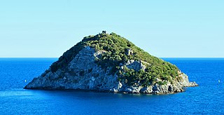
Rocca Barbena Mountain in Italy

Rocca Barbena is a 1,142-metre (3,747 ft) high mountain in the Ligurian Prealps in Italy.

Carmo di Brocchi Mountain in Italy

Carmo di Brocchi is a 1,610-metre (5,282 ft) mountain of the Ligurian Alps, in Italy.

Monte Spinarda Mountain in Italy

Monte Spinarda is a 1,357-metre (4,452 ft) mountain of the Ligurian Prealps in Italy.

Monte Alpesisa Mountain in Italy

Monte Alpesisa is a 989 metres high mountain in the Ligurian Apennines, in Italy.

Monte della Guardia Mountain in Italy

The Monte della Guardia is a mountain in Piedmont, northern Italy, part of the Alps. At an altitude of 1,658 metres is one of the highest summits of the Ligurian Prealps.

Cima della Fascia Mountain in Italy

The Cima della Fascia is a mountain of the Ligurian Alps located in Piedmont.

Monte Antoroto Mountain in Italy

The Monte Antoroto is a mountain of the Ligurian Alps located in Piedmont.

Punta Mirauda Mountain in Italy

The Punta Mirauda is a mountain of the Ligurian Alps located in Piedmont.

Monte Cianea Mountain in Italy

Monte Cianea is a 1,226-metre (4,022 ft) mountain of the Ligurian Prealps, in Italy.

Monte Peso Grande Mountain in Italy

Monte Peso Grande o Castell'Ermo (1.092 m) is a mountain of the Ligurian Prealps, the eastern section of the Ligurian Alps.

Monte Camulera Mountain in Italy

The Monte Camulera is a mountain of the Ligurian Prealps, the eastern section of the Ligurian Alps.

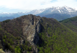
The Ligurian Prealps are a mountain range in northwestern Italy. They belong to the Ligurian Alps and are located between the regions of Piemonte and Liguria. Their highest summit is the monte Armetta, at an elevation of 1,739 metres (5,705 ft).

References

  1. 1 2 3 4 Limiti Amministrativi (Comunali, Provinciali, Regionali) sc. 1:25000 - ed. 2011; Regione Liguria, on-line version: geoportale.regione.liguria.it
  2. Key col: Colla Baltera, 794 m
  3. Liguria, pagine 365; AA.VV., ed. Touring Club Italiano, anno 1982
  4. Traversata del monte Ronco di Maglio, web-page on www.liguriabike.it (access: March 2017)
  5. Bollettino Ufficiale Regione Liguria nr.13 of 15-7-2009; the Ligurian SIC list is on-line at lrv.regione.liguria.it Archived 2016-03-05 at the Wayback Machine (access: July 2015)