
The Alps are the highest and most extensive mountain range system that lies entirely in Europe, stretching approximately 750 mi (1,210 km) across eight Alpine countries : France, Switzerland, Monaco, Italy, Liechtenstein, Austria, Germany, and Slovenia.

A mountain range or hill range is a series of mountains or hills ranged in a line and connected by high ground. A mountain system or mountain belt is a group of mountain ranges with similarity in form, structure, and alignment that have arisen from the same cause, usually an orogeny. Mountain ranges are formed by a variety of geological processes, but most of the significant ones on Earth are the result of plate tectonics. Mountain ranges are also found on many planetary mass objects in the Solar System and are likely a feature of most terrestrial planets.

The Rocky Mountains, also known as the Rockies, are a major mountain range and the largest mountain system in North America. The Rocky Mountains stretch 3,000 mi (4,800 km) in straight-line distance from the northernmost part of western Canada, to New Mexico in the southwestern United States. Depending on differing definitions between Canada and the United States, its northern terminus is located either in northern British Columbia's Terminal Range south of the Liard River and east of the Trench, or in the northeastern foothills of the Brooks Range/British Mountains that face the Beaufort Sea coasts between the Canning River and the Firth River across the Alaska-Yukon border. Its southernmost point is near the Albuquerque area adjacent to the Rio Grande Basin and north of the Sandia–Manzano Mountain Range. Being the easternmost portion of the North American Cordillera, the Rockies are distinct from the tectonically younger Cascade Range and Sierra Nevada, which both lie farther to its west.

A mountain is an elevated portion of the Earth's crust, generally with steep sides that show significant exposed bedrock. A mountain differs from a plateau in having a limited summit area, and is larger than a hill, typically rising at least 300 metres above the surrounding land. A few mountains are isolated summits, but most occur in mountain ranges.
The Himalayas, or Himalaya, are a mountain range in Asia separating the plains of the Indian subcontinent from the Tibetan Plateau. The range has some of the planet's highest peaks, including the highest, Mount Everest. Over 100 peaks exceeding 7,200 m (23,600 ft) in elevation lie in the Himalayas. By contrast, the highest peak outside Asia is 6,961 m (22,838 ft) tall.
Mount Everest is Earth's highest mountain above sea level, located in the Mahalangur Himal sub-range of the Himalayas. The China–Nepal border runs across its summit point. Its elevation of 8,848.86 m (29,031.7 ft) was most recently established in 2020 by the Chinese and Nepali authorities.
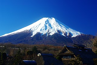
Mount Fuji, or Fugaku, located on the island of Honshū, is the highest mountain in Japan, standing 3,776.24 m (12,389.2 ft). It is the second-highest volcano located on an island in Asia, and seventh-highest peak of an island on Earth. Mount Fuji is an active stratovolcano that last erupted from 1707 to 1708. The mountain is located about 100 km (62 mi) southwest of Tokyo and is visible from there on clear days. Mount Fuji's exceptionally symmetrical cone, which is covered in snow for about five months of the year, is commonly used as a cultural icon of Japan and it is frequently depicted in art and photography, as well as visited by sightseers and climbers.

The Sierra Nevada is a mountain range in the Western United States, between the Central Valley of California and the Great Basin. The vast majority of the range lies in the state of California, although the Carson Range spur lies primarily in Nevada. The Sierra Nevada is part of the American Cordillera, an almost continuous chain of mountain ranges that forms the western "backbone" of the Americas.

The Adirondack Mountains form a massif in northeastern Upstate New York, which is part of the United States. Its boundaries correspond roughly to the boundaries of Adirondack Park. They cover about 5,000 square miles (13,000 km2). The mountains form a roughly circular dome, about 160 miles (260 km) in diameter and about 1 mile (1,600 m) high. The current relief owes much to glaciation. There are more than 200 lakes around the mountains, including Lake George, Lake Placid, and Lake Tear of the Clouds, which is the source of the Hudson River. The Adirondack Region is also home to hundreds of mountain summits, with some reaching heights of 5,000 feet or more.

The Appalachian Mountains, often called the Appalachians, are a system of mountains in eastern to northeastern North America. The Appalachians first formed roughly 480 million years ago during the Ordovician Period. They once reached elevations similar to those of the Alps and the Rocky Mountains before experiencing natural erosion. The Appalachian chain is a barrier to east–west travel, as it forms a series of alternating ridgelines and valleys oriented in opposition to most highways and railroads running east–west.
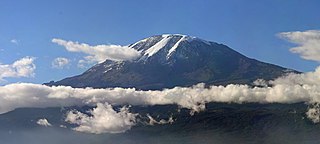
Mount Kilimanjaro is a dormant volcano in Tanzania. It has three volcanic cones: Kibo, Mawenzi, and Shira. It is the highest mountain in Africa and the highest single free-standing mountain above sea level in the world: 5,895 metres (19,341 ft) above sea level and about 4,900 metres (16,100 ft) above its plateau base. It is the highest volcano in Africa and the Eastern Hemisphere.

Denali is the highest mountain peak in North America, with a summit elevation of 20,310 feet (6,190 m) above sea level. With a topographic prominence of 20,194 feet (6,155 m) and a topographic isolation of 4,621.1 miles (7,436.9 km), Denali is the third most prominent and third most isolated peak on Earth, after Mount Everest and Aconcagua. Located in the Alaska Range in the interior of the U.S. state of Alaska, Denali is the centerpiece of Denali National Park and Preserve.

The Caucasus Mountains is a mountain range at the intersection of Asia and Europe. Stretching between the Black Sea and the Caspian Sea, it is surrounded by the Caucasus region and is home to Mount Elbrus, the highest peak in Europe at 5,642 metres (18,510 ft) above sea level.

In geology and physical geography, a plateau, also called a high plain or a tableland, is an area of a highland consisting of flat terrain that is raised sharply above the surrounding area on at least one side. Often one or more sides have deep hills. Plateaus can be formed by a number of processes, including upwelling of volcanic magma, extrusion of lava, and erosion by water and glaciers. Plateaus are classified according to their surrounding environment as intermontane, piedmont, or continental. A few plateaus may have a small flat top while others have wide ones.

The mountains and hills of the British Isles are categorised into various lists based on different combinations of elevation, prominence, and other criteria such as isolation. These lists are used for peak bagging, whereby hillwalkers attempt to reach all the summits on a given list, the oldest being the 282 Munros in Scotland, created in 1891.

The Black Sea Region is a geographical region of Turkey.

An ultra-prominent peak, or Ultra for short, is a mountain summit with a topographic prominence of 1,500 metres (4,900 ft) or more; it is also called a P1500. The prominence of a peak is the minimum height of climb to the summit on any route from a higher peak, or from sea level if there is no higher peak. There are approximately 1,524 such peaks on Earth. Some well-known peaks, such as the Matterhorn and Eiger, are not Ultras because they are connected to higher mountains by high cols and therefore do not achieve enough topographic prominence.
The Muskwa-Kechika Management Area is a provincially run tract of land in the far north of British Columbia. It has an advisory board that advises the government on land-use decisions. Established by provincial government legislation in 1998, the area is meant to be preserved as a wild area, but development is not forbidden. The land is divided into different zones, with varying levels of protection, although the whole area is supposed to be used according to an overall plan. The original plan called for 25% of the land to be turned into provincial parks, 60% to become "special management zones" where mining and oil and gas drilling was to be allowed, and 15% to become "special wildland zones" where logging is prohibited. The original size of the M-KMA was 4,450,000 hectares however in 2000 with the approval of the Mackenzie Land and Resource Management Plan (LRMP) over 1,900,000 hectares were added to the M-KMA creating a total area of 6,400,000 hectares, which is approximately the size of the US state of Maine, or the island of Ireland, or seven times the size of Yellowstone National Park in the United States.
