
Freguesia, usually translated as "parish" or "civil parish", is the third-level administrative subdivision of Portugal, as defined by the 1976 Constitution. It is also a local administrative unit in the former Portuguese overseas territories of Cape Verde and Macau. In the past, was also an administrative division of the other Portuguese overseas territories. The parroquia in the Spanish autonomous communities of Galicia and Asturias is similar to a freguesia.
Santa Maria da Feira is a city and a municipality in Aveiro District in Portugal. The population in 2011 was 139,309, in an area of 215.88 km².

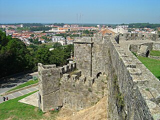
Castelo de Paiva is a town and a municipality of the Aveiro District in Portugal. The population in 2011 was 16,733, in an area of 115.01 km².

Paço de Arcos is a locality of Oeiras. In 2013, the parish of Paço de Arcos merged into the new parish Oeiras e São Julião da Barra, Paço de Arcos e Caxias. The population in 2011 was 15,315, in an area of 3.39 km². It was elevated to town by a decree at December 7, 1926.

Mangualde is a municipality in the subregion of Dão-Lafões, central region of Portugal. The population in 2011 was 19,880, in an area of 219.26 km2.

Celorico da Beira is a municipality in Guarda District in Portugal. The municipality population in 2011 was 7,693, in an area of 247.22 km².

Fornos de Algodres is a municipality and a town in Portugal. The population in 2011 was 4,989, in an area of 131.45 km². The municipality is located in Guarda District, Centro Region, Serra da Estrela Subregion. The present Mayor is José Severino Soares Miranda, elected by the Social Democratic Party. The municipal holiday is September 29.

Fornos is a Portuguese parish, located in the municipality of Santa Maria da Feira. The population in 2011 was 3,397, in an area of 3.14 km².
Guisande is a former civil parish in the municipality of Santa Maria da Feira, Portugal. In 2013, the parish merged into the new parish Lobão, Gião, Louredo e Guisande. It has a population of 1,474 inhabitants and a total area of 3.78 km². Guisande is located approximately 30 km south of Porto and 320 km north from the capital city of Lisbon.
Aldeia de Paio Pires is a former civil parish in the municipality (concelho) of Seixal, Lisbon Metropolitan Area, Portugal. In 2013, the parish merged into the new parish Seixal, Arrentela e Aldeia de Paio Pires. The population in 2011 was 13,258, in an area of 15.96 km².
Querença is a former civil parish in the municipality of Loulé, eastern Algarve, Portugal. In 2013, the parish merged into the new parish Querença, Tôr e Benafim. Located north of Loulé proper, Querença is an area of 37.18 square kilometres (14.36 sq mi) with a population of 759 inhabitants.
Algodres is a Portuguese civil parish (freguesia) in the municipality of Fornos de Algodres, district of Guarda. The population in 2011 was 349, in an area of 10.15 km².
Sobral Pichorro is a former civil parish in the municipality of Fornos de Algodres, district of Guarda, Portugal. In 2013, the parish merged into the new parish Sobral Pichorro e Fuinhas.
Abrunhosa-a-Velha is a civil parish in the municipality of Mangualde in the central sub-region of Dão-Lafões in Portugal. The population in 2011 was 563, in an area of 17.30 km².
Fornos de Maceira Dão is a freguesia in Mangualde, Portugal. The population in 2011 was 1,459, in an area of 16.25 km².

António José Antunes Navarro, 1st Count of Lagoaça was a Portuguese nobleman and politician.
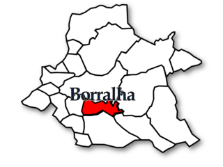
Borralha was a freguesia in Águeda Municipality, Aveiro District, Portugal. It had an area of 9.6 km2 and in 2011 had a population of 2230.
Sobral Pichorro e Fuinhas is a civil parish in the municipality of Fornos de Algodres, Portugal. It was formed in 2013 by the merger of the former parishes Sobral Pichorro and Fuinhas. The population in 2011 was 300, in an area of 15.17 km².

