
The Taupō Volcanic Zone (TVZ) is a volcanic area in the North Island of New Zealand that has been active for at least the past two million years and is still highly active. Mount Ruapehu marks its south-western end and the zone runs north-eastward through the Taupō and Rotorua areas and offshore into the Bay of Plenty. It is part of the larger Central Volcanic Region that extends further westward through the western Bay of Plenty to the eastern side of the Coromandel Peninsula and has been active for four million years. At Taupō the rift volcanic zone is widening east–west at the rate of about 8 mm per year while at Mount Ruapehu it is only 2–4 mm per year but this increases at the north eastern end at the Bay of Plenty coast to 10–15 mm per year. It is named after Lake Taupō, the flooded caldera of the largest volcano in the zone, the Taupō Volcano and contains a large central volcanic plateau as well as other landforms associated with its containing tectonic intra-arc continental Taupō Rift.
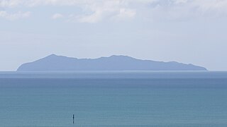
Mayor Island / Tūhua is a dormant shield volcano located off the Bay of Plenty coast of New Zealand's North Island. It lies 35 kilometres (22 mi) north of Tauranga and covers 13 km2 (5 sq mi).

Matakana Island is located in the western Bay of Plenty in New Zealand's North Island. A long, flat barrier island, it is 20 kilometres (12 mi) in length but rarely more than 3 kilometres (1.9 mi) wide. The island has been continuously populated for centuries by Māori tribes that are mostly associated with Ngāi Te Rangi.
Lake Rotokākahi or Green Lake, is one of four small lakes lying between Lake Rotorua and Lake Tarawera in the Bay of Plenty Region of New Zealand's North Island. The others are Lake Tikitapu, Lake Ōkāreka, and Lake Ōkataina. All lie within the Ōkataina Caldera, along its western edge.

Lake Ōkataina is the northernmost and largest of four smaller lakes lying between Lake Rotorua and Lake Tarawera in the Bay of Plenty Region of New Zealand's North Island. The others are Lake Rotokakahi, Lake Tikitapu, and Lake Ōkareka. All lie within the Ōkataina caldera, along its western edge.
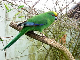
Cyanoramphus malherbi is a small parrot endemic to New Zealand, where it is known as the orange-fronted parakeet or orange-fronted kākāriki. In the rest of the world it is called Malherbe's parakeet, as when it was recognised as a species, the name "orange-fronted parakeet" was already used for Eupsittula canicularis, a Central American species. Restricted to a few valleys in the South Island and four offshore islands, its population declined to around 200 in the 1990s, and it is considered critically endangered by the IUCN.

Ngāi Te Rangi or Ngāiterangi is a Māori iwi, based in Tauranga, New Zealand. Its rohe extends to Mayor Island / Tuhua and Bowentown in the north, to the Kaimai Range in the west, south of Te Puke and to Maketu in the east.

Oropi is a rural settlement located in the Bay of Plenty region of the North Island of New Zealand. It is located 20 kilometres south of Tauranga and 43 kilometres north of Rotorua. It has been suggested that the word Oropi is the Māori language equivalent of Europe. This is derived from the 1860s when government forces were based in the area at the time of the Battle of Gate Pā.
Ngāti Ranginui is a Māori iwi (tribe) in Bay of Plenty, New Zealand. Its rohe extends from Waihi in the north, to the Kaimai Range in the west, to south of Te Puke in the south, and to Tauranga in the east. The rohe does not extend offshore to Matakana Island or Mayor Island / Tuhua.

Rotorua Lakes District or Rotorua District is a territorial authority district in the North Island of New Zealand. It has one urban area of significant size, the city of Rotorua. The district is governed by Rotorua Lakes Council, which is headquartered in Rotorua and is headed by a mayor. The district falls within two regional council areas, with the majority of the area and Rotorua city in the Bay of Plenty Region and the rest in the Waikato region. Tania Tapsell has been the mayor of Rotorua since the 2022 local elections.

Ngāti Pūkenga is a Māori iwi centred in Tauranga in the Bay of Plenty region of New Zealand. Its rohe extends to Mayor Island / Tuhua and Waihi in the north, to the Kaimai Range in the west, south of Te Puke and to Maketu in the east, and it has tribal holdings in Whangarei, Hauraki and Maketu.
The region around the city of Rotorua, in New Zealand's North Island, contains several lakes which have a total area of about 250 square kilometres. The term Rotorua lakes is ambiguous as it has been used historically for a New Zealand administrative area. From biggest to smallest, these are Lake Rotorua, Lake Tarawera, Lake Rotoiti, Lake Rotomā, Lake Okataina, Lake Rotoehu, Lake Rotomahana, Lake Rerewhakaaitu, Lake Rotokākahi, Lake Okareka and Lake Tikitapu. There are also smaller lakes including: Lake Okaro, Lake Rotokawa, Lake Rotokawau and Lake Rotongata. Most of the lakes have formed due to volcanic activity and some have current geothermal activity. The region is part of the Taupō Volcanic Zone, the world's most active area of explosive silicic volcanic activity in geologically recent time.

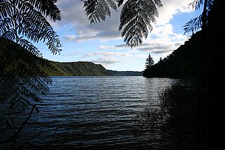
Lake Te Paritu, also known as Black Lake, is one of two small crater lakes on Mayor Island / Tuhua in the Bay of Plenty, New Zealand. It is connected to the larger Lake Aroarotamahine or Green Lake by a wetland, but there is no surface outlet to the sea as both lakes are in a depression.
Pōmare I was a New Zealand Māori rangatira (chief) of the Ngāti Manu hapū (subtribe) of the Ngāpuhi iwi (tribe). Formerly called Whētoi, he adopted the name of Pōmare, after the name of the king of Tahiti who had converted to Christianity. After his death he was called Pōmarenui by Ngāti Manu in order to distinguish him from his nephew Whiria, who also took the name Pōmare.
A mayor is the highest-ranking official in a municipal government such as that of a city or a town.
The Mayor of Western Bay of Plenty officiates over the Western Bay of Plenty District of New Zealand's North Island.

The Bay of Plenty District Health Board was a district health board with the focus on providing healthcare to the Bay of Plenty area of New Zealand. In 2022, the Bay of Plenty DHB was dissolved as part of a national overhaul of the district health board system. Its former functions and responsibilities were assumed by Te Whatu Ora.
Motunau / Plate Island is a small island in the Bay of Plenty, roughly 12 kilometres (7.5 mi) off New Zealand's North Island at Okurei Point and a similar distance east-south-east from the much larger Mōtītī Island. The island is split into northern and southern portions by a small channel as narrow as 2 metres across, with several small sea stacks surrounding the two main parts of the island. Like many of the other islands in the Bay of Plenty, Motunau is volcanic in origin and lacks any permanent fresh water source, and as a result has not seen permanent settlement by humans.

