Related Research Articles

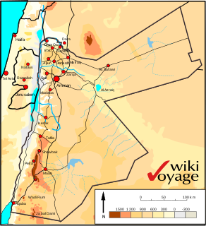
The Dead Sea is a salt lake bordered by Jordan to the east and Israel and the West Bank to the west. It lies in the Jordan Rift Valley, and its main tributary is the Jordan River.
Jordan is situated geographically in Southwest Asia, south of Syria, west of Iraq, northwest of Saudi Arabia and east of Palestine and the West Bank; politically, the area has also been referred to in the West as the Middle or Near East. The territory of Jordan now covers about 91,880 square kilometres (35,480 sq mi).

The Jordan River or River Jordan, also known as Nahr Al Sharieat, is a 251-kilometre-long (156 mi) river in the Middle East that flows roughly north to south through the Sea of Galilee and on to the Dead Sea. Jordan and the Golan Heights border the river to the east, while the West Bank and Israel lie to its west. Both Jordan and the West Bank take their names from the river.
The 10th millennium BC spanned the years 10,000 BC to 9001 BC. It marks the beginning of the transition from the Palaeolithic to the Neolithic via the interim Mesolithic and Epipaleolithic periods, which together form the first part of the Holocene epoch that is generally believed to have begun c. 9700 BC and is the current geological epoch. It is impossible to precisely date events that happened around the time of this millennium and all dates mentioned here are estimates mostly based on geological and anthropological analysis.

The Southern Levant is a geographical region encompassing the southern half of the Levant. It corresponds approximately to modern-day Israel, Palestine, and Jordan; some definitions also include southern Lebanon, southern Syria and/or the Sinai Peninsula. As a strictly geographical description, it is sometimes used by archaeologists and historians to avoid the religious and political connotations of other names for the area.

Arabah is a loosely defined geographic area south of the Dead Sea basin, which forms part of the border between Israel to the west and Jordan to the east.

The Red Sea–Dead Sea Conveyance (RSDSC), sometimes called the Two Seas Canal, is a planned pipeline to run from the coastal city of Aqaba by the Red Sea to the Lisan area in the Dead Sea. It will provide potable water to Jordan, Israel and the Palestinian territories, bring water with a high concentration of salts resulting from the desalination process to stabilise the Dead Sea water level, and generate electricity to support the energy needs of the project. The project is planned to be carried out by Jordan and is entirely in Jordanian territory. It will be financed by the governments of Jordan, Israel, and a number of international donors.

Wadi Mujib, which is also "almost certainly" the biblical Arnon Stream, is a river canyon in Jordan which enters the Dead Sea c 420 metres (1,380 ft) below sea level.
Adamantios Sampson is a Greek archaeologist who served as an Inspector of Antiquities for the Greek Administration of Antiquity. Since 1999, he has been a professor in the University of the Aegean, Department of Mediterranean Studies, Rhodes

In the archaeology of Southwest Asia, the Late Neolithic, also known as the Ceramic Neolithic or Pottery Neolithic, is the final part of the Neolithic period, following on from the Pre-Pottery Neolithic and preceding the Chalcolithic. It began around 6,400 BCE in the Fertile Crescent, succeeding the period of the Pre-Pottery Neolithic. By then distinctive cultures emerged, with pottery like the Halafian and Ubaid. This period has been further divided into PNA and PNB at some sites.

Ghassulian refers to a culture and an archaeological stage dating to the Middle and Late Chalcolithic Period in the Southern Levant. Its type-site, Teleilat Ghassul, is located in the eastern Jordan Valley near the northern edge of the Dead Sea, in modern Jordan. It was excavated in 1929-1938 and in 1959–1960, by the Jesuits. Basil Hennessy dug at the site in 1967 and in 1975–1977, and Stephen Bourke in 1994–1999.

Bronze Age Britain is an era of British history that spanned from c. 2500 until c. 800 BC. Lasting for approximately 1,700 years, it was preceded by the era of Neolithic Britain and was in turn followed by the period of Iron Age Britain. Being categorised as the Bronze Age, it was marked by the use of copper and then bronze by the prehistoric Britons, who used such metals to fashion tools. Great Britain in the Bronze Age also saw the widespread adoption of agriculture.

Hamadia is a kibbutz in the Beit She'an Valley, just north of Beit She'an in northern Israel. It belongs to the Valley of Springs Regional Council. In 2019 it had a population of 381.
This timeline of prehistory covers the time from the first appearance of Homo sapiens in Africa 315,000 years ago to the invention of writing and the beginning of history, 5,000 years ago. It thus covers the time from the Middle Paleolithic to the very beginnings of world history.
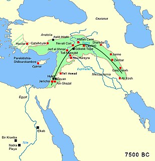
The Pre-Pottery Neolithic (PPN) represents the early Neolithic in the Levantine and upper Mesopotamian region of the Fertile Crescent, dating to c. 12,000 – c. 8,500 years ago,. It succeeds the Natufian culture of the Epipalaeolithic Near East, as the domestication of plants and animals was in its formative stages, having possibly been induced by the Younger Dryas.

The Yarmukian culture was a Pottery Neolithic A (PNA) culture of the ancient Levant. It was the first culture in prehistoric Israel and one of the oldest in the Levant to make use of pottery. The Yarmukian derives its name from the Yarmuk River, which flows near its type site of Sha'ar HaGolan, near Kibbutz Sha'ar HaGolan at the foot of the Golan Heights. This culture existed alongside the Lodian, or Jericho IX culture and the Nizzanim culture to the south.
The Zarqa River is the second largest tributary of the lower Jordan River, after the Yarmouk River. It is the third largest river in the region by annual discharge and its watershed encompasses the most densely populated areas east of the Jordan River. It rises in springs near Amman, and flows through a deep and broad valley into the Jordan, at an elevation 1,090 metres (3,580 ft) lower.
Abu Zurayq is an archaeological site named after the modern village that existed there, located on the western edge of the Jezreel Valley and its transition to the Menashe Heights. It is located next to Highway 66, between the modern kibbutzim of HaZore'a and Mishmar HaEmek.

Lake Lisan was a prehistoric lake that existed between 70,000 and 12,000 BP in the Jordan Rift Valley in the Near East. It is sometimes referred to as a Pleistocene lake.

Munhata is an archaeological site 11 kilometres (6.8 mi) south of Lake Tiberias, Israel on the north bank and near the outlet of Nahal Tavor on a terrace 215 metres (705 ft) below sea level.
References
- 1 2 3 Smith R. H. & Koucky F. L., Lake Beisan and the Prehistoric Settlement of the Northern Jordan Valley, Paléorient, Volume 12, Issue 12-2, pp. 27-36
- ↑ Leo Picard (1929). Zur Geologie der Bēsān-Ebene. J. C. Hinrichs. Retrieved 13 April 2011.
- ↑ David Neev; Kenneth Orris Emery (1967). The Dead Sea: depositional processes and environments of evaporites. Ministry of Development Geological Survey of Israël. Retrieved 13 April 2011.